2021-04-23 EVENT: TX/OK/LA/AR/MS

Joined
Oct 10, 2004
Messages
1,428
Location
Madison, WI
SPC has a Day 4 risk area in place. A cursory glance over the 20/12Z GFS run shows a rather narrow axis of 2000-2500 j/kg SBCAPE nosing up into SW OK at 24/00Z. Forecast soundings within that area show stout winds with height and decent low-level turning, there is some veer-backing shown but it's mostly above 700mb. Some of the soundings hint that capping might be an issue as well, although it could also help keep storms better spaced for chaseable supercells.

NAM at the tail end of its range is similar, with a somewhat wider quality warm sector/CAPE axis.

Those more experienced can chime in with more detailed analysis if they care to. Either way, it looks like the first legit chase day for parts of the Plains following this mid-April lull.

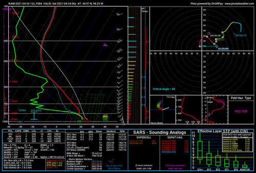
Attached is a NAM forecast sounding; winds look fairly unidirectional above 850mb but there is pretty tight veering from SSE to SW below that, also any veer-backing is very slight. It also pops the pretty purple color in the "psbl hazard type" box.
 

Attachments

  • nam_2021042012_084_34.97--98.25.png
    nam_2021042012_084_34.97--98.25.png
    241.1 KB · Views: 0
Last edited:
Quite an interesting setup shaping up 24 hours out with even SPC expressing some uncertainty in their morning forecast about this day. Triple point initiation which looks be around Childress to Wichita falls is indicated but in a time window where the cold front starts crashing down undercutting any rotating updrafts that way. However, the target box of Wichita Falls-Ardmore-Dallas-Abilene is very intriguing given a sharp negatively tilted dryline shapes up around Abilene southward with nice 2000-3500 J/KG MU-Cape with triple point moving easterly along the Red River and models indicate cap really erodes at 2-3 p.m. Sig tors really spike from 5-8 p.m. in the Dallas area as the LLJ comes in and torques up low level shear. Lift and LCLs look awfully nice as well. Current radar sims don't indicate any dryline initiation in this area and indicate shortwave initiation in eastern Texas. If a storm pops off that dryline, any cell is going to be golden given the atmosphere it is going to travel in the late afternoon/early evening time window. Seems like it would be worth the gamble.
 
Looks like a solid setup tomorrow near the triple point in southwest Oklahoma/northwest Texas. Like that the upper trough is overhead which will create favorable thermodynamics with steep lapse rates. This is assuming central Texas convection doesn't impede low-level moisture advection into the low. A photogenic supercell or two appears reasonable with a tornado threat especially near the surface low where enhanced low-level vorticity should exist.
 
Yeah overall the triple point region is looking pretty decent around the TX/OK border region this afternoon/evening. It seems like there will be a fair bit of separation between that environment and the heavy convection expected throughout eastern TX this morning. Pretty fat cape in the hail growth zone as well so perhaps could be looking at some very large hail potential! I wouldn't be surprised too to see some action extending a smidge west into the panhandle. If I were chasing today I'd target the southwestern corner of Oklahoma and try to be there around 2PM. I think the setup looks better this morning than it has basically every day leading up to today so. It'll be interesting to see what the SPC suggests this AM as I haven't been over to their site yet.
 
First images from visible satellite suggest there should be at least modest insolation over target area near triple point today. There is a thin cirrus plume moving overhead and some low-level clouds, but it doesn't appear to be completely socked in with heavy clouds. Concern still exists with midday/afternoon storms in WAA regime across much of central Texas into southern Oklahoma and their possible impacts on instability and moisture advection into target area. The upper trough produced snow overnight over the southern Rockies which is a good omen for plains chasing prospects. Morning soundings show substantial capping inversion across southern Texas in warm sector and this may limit southward development of storms along dryline with the exception being in the vicinity of the triple point. CAM solutions support this idea.

Expect a couple of supercells to fire near triple point in Childress, TX vicinity by late afternoon with very large hail and damaging winds. Vertical vorticity near surface low may be sufficient for some tornado risk with any dominant supercell. Wouldn't be totally surprised to see this threat by late afternoon, but more likely closer to 00z as low-level jet begins to increase. Upscale growth into an MCS will occur during the evening.

Good luck and safe travels to everyone who ventures out today.
 
I live in Altus, OK (more likely the storms will track ME down today rather than the other way around) and it has been overcast with intermittent mist most of the morning, but I have begun seeing some thinning in the clouds, which tracks with what @Greg McLaughlin noted on satellite. Since I live right in the target area, won't be much of a chase day for me, but I'll use the opportunity to brush the cobwebs off the camera and get that dialed back in if nothing else. Hopefully any damaging hail misses my house!
 
Can a mod edit the thread title to include the eastern risk area (LA/MS/AR)? As the OP I thought I could do it myself, but apparently not or else I just can't locate the option. Although, as @Michael Norris noted, the primary chasing interest will be the western target due to storm quality and terrain.
 
Back
Top