• While Stormtrack has discontinued its hosting of SpotterNetwork support on the forums, keep in mind that support for SpotterNetwork issues is available by emailing [email protected].

2020-06-06 REPORTS: UT/CO/WY/NE/SD/ND

John Farley

Supporter
Joined
Apr 1, 2004
Messages
1,968
Location
Pagosa Springs, CO
I thought about posting this in the thread about this day's derecho event in the Weather in the News section, but since it is a first-hand chase accout it seemed per the rules that it should be posted here. I headed out from Pagosa Springs, CO for a local chase in hopes of seeing something good, and did manage to get a transient supercell before the storms totally lined out, so I am happy. You can see my full report at:


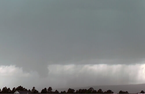
In the meantime, here is a picture of a wall cloud that formed in association with the transient supercell northwest of Pagosa Springs:

chase60620-3.jpg
 

Attachments

  • vidcap3-60620.jpg
    vidcap3-60620.jpg
    411.5 KB · Views: 0
I made the trip from Danville Illinois to chase this event and was not disappointed. This was only my 2nd plains chase, but I was positioned near Faith South Dakota for these pictures. Easily the most impressive shelf cloud I´ve seen in person. Got turned around at the Indian Reservation just east of Faith and then I just had to suck it up and take mother nature´s punishment. The thing that stood out to me other than the structure was the lightning. It looked almost like strobe lights. Got the gorgeous sunset as I got back today.20200606_192036.jpg20200606_192008.jpg20200606_185041.jpg20200606_184156.jpg20200608_203607.jpg
 
Back
Top