• While Stormtrack has discontinued its hosting of SpotterNetwork support on the forums, keep in mind that support for SpotterNetwork issues is available by emailing [email protected].

2019-08-15 REPORTS: KS

Joined
Jan 16, 2009
Messages
774
Location
Kansas City
Obvious target day so we headed to around Junction City. We got on the first cell that stayed organized until it split and took a SE turn.
Here it is as it approached I-70 east of Junction City … it dropped a brief tornado just south of I-70 about ten minutes after this shot.

1.jpg

Once over I-70 it started to really get its act together and had this amazing rotating wall cloud on it.

2.jpg

This is the second tornado the cell produced about 10 minutes after the wall cloud photo.
3.jpg

We tracked this cell and watched it drop at least 4 more tornadoes after dark.
4.jpg

Not long after the above dropped we had a brief spin up a half block from us where trees were hit and a branch as throw done the street towards us. I do not know what other chases were there with us but love to hear the stories as they ducked behind my truck for cover. LOL!
 
This was sort of an absurd day for me: not in a good or bad way, just funny and ridiculous. I woke up in Burlington, CO, about 90% set on heading W to hike in the mountains after chasing the previous day. I stayed in my room almost until check-out casually browsing routes and trails in RMNP and surrounding areas, barely even paying attention to weather data. Around 10am MDT, I started heading W on I-70 and made it almost 30 miles to Vona before pulling off and giving the data one final look. After clearing my head, I begrudgingly chose the eastbound entrance ramp, and the rest is history. It was almost a 5-hour jaunt on I-70 from Vona, CO, to Junction City, KS, but I still had some time to spare before the storm of the day initiated NW of MHK around 5:45pm CDT.

The point of CI was laughably and predictably bad for chasers: just NW of the worst terrain in all of KS *and* a large military facility. Exasperated, I decided to pull right under the updraft base early on near Riley, knowing I'd have to drop way back regardless once it moved over the facility.

2019-08-15_6516.jpg


2019-08-15_6517.jpg


After a short viewing window, I looped back through Junction City and watched the base cross I-70 just E of there. Keeping with the theme of the previous day, this SE-moving storm seemed bound and determined to maximize chaser frustration in choosing road options. I hesitated for awhile to push E on the interstate to K177 southbound due to the hail threat, but -- thank the heavens -- eventually decided to roll the dice (and ended up with nothing more than moderately heavy rain). While heading S toward Alta Vista, the first (highly visible) tornado of the day occurred off to the E as a cone that lasted around 60 seconds. I was only able to shoot handheld video while driving before it dissipated.

vidcap_20190815_001.jpg


Heading E on KS-4 out of Alta Vista, I finally regained good position just ahead of the base and watched some nice structure at sunset, hoping in vain for a new touchdown from this nicer vantage point.

2019-08-16_6522.jpg


Eventually, another tornado occurred somewhere E of Volland and SW of Alma at dusk, around 8:45pm. This was an occluded circulation well NW of the newest, most obvious mesocyclone at that point; thus, I only noticed it to my N after it had been ongoing for probably a minute or two. I scrambled to find a hilltop and managed to shoot some telephoto stills for a few minutes before it roped out.

2019-08-16_6552.jpg


2019-08-16_6554.jpg


2019-08-16_6557.jpg


Afterwards, I attempted to continue ESE as this storm produced multiple additional tornadoes after dark, but quickly realized the futility given the road options. Having lost data for a fairly long period by now, a new, intense trailing supercell had an unpleasant surprise in store as I scurried back W toward Alta Vista: sporadic golfballs and some of the most blinding rain I've ever experienced after dark.

When I flipped my car around to return eastbound on I-70 in the morning, it was a decision made primarily out of FOMO and desperation, so I couldn't be happier that it paid off. These were my first August tubes, and it doesn't seem too much of a stretch to say we might go decades without another easily-targetable opportunity like that in KS.
 
Last edited:
Figure I'll add my ventures in on the day given it's been a hot second since the last time I had a chase of note to post...

Started the day with my usual obligations to cover potential severe weather here in the KAKEland viewing area, and fortunately the cap did its thing. I stationed in Minneapolis, KS for the newscasts, and watched as the Clay County storms got their act together. As I finished my live hits, I had watched the CU-field in my area and points west disintegrate into clear skies, so I knew I was free to roam beyond the borders. I jumped east on K-18 and caught the storm as it approached Junction City.

I trailed down to I-70, figuring my next south route was going to be K-177 coming out of Manhattan, so I tracked the viciously rotating wall cloud as it approached the interstate. I was certain it was going to drop a big tube on the highway, enough so where I pulled off on the shoulder somewhere just south of Ogden before the storm crossed the road as I did not want to get involved with something I was not ready to cash a check for.

19316

The storm went into a cycle, and I got to K-177. And as lucky as 7s are for me, I knew I was probably in for a lovely evening.

This storm had crazy motion on it, and was rotating as fast as a storm could that wasn't producing tubes. When I stopped somewhere between I-70 and Alta Vista, the main area of concern was to the west of K-177. As that occluded, a new area of rotation quickly developed, and a beautiful wall cloud was again parading a carousel over open fields, this time east of K-177.


My stopping point required a little finesse to get back out of, and I got back on the road and drove a bit south. As I looked for a safe place to pull off the road, the initial tornado came down. I missed the point at it's most condensed, but managed to get a camera on it for a couple shots. Sadly, it didn't hang on long, which was made even worse by having decent lighting to work with.

19309

Darkness started to fall, and I got back south around the front end of the storm, positioning somewhere north of K-4 just east of Alta Vista. I think I was a couple miles north of the highway on some dirt road. That is where I saw the second tornado. As dark as it was, the lightning was the best visual aid, and while the video (and my terrible attempt at photos) turned out pretty crappy, I managed a couple of still that tell the tale.

19310

After the tornado lifted, the lightning kinda took the show, so I better setup my still camera and snagged a couple decent lightning shots. The lightning took a bit of a reprieve, so I packed the camera away.

19311

I did take a break to throw together a little video for my news station as we lacked any storms in our area, and whose going to turn down tornado video to put on TeeVee. I was getting my video downloaded and edited in the same place I had just seen the tornado. Well, remember the lightning? Yeah, I certainly did, because one of those bolts hit a tree/pole/fence post within feet of my car. All my windows were up and I was safely tucked away in the car, but felt the burning on the left side of my body from the proximity of the strike. I was not electrocuted or shocked, but felt the heat as intensely as I have felt from a lightning strike. Was VERY happy I had packed the gear away and got back in the car moments earlier, cause who knows how that would've turned out otherwise.

But my night was not over... although it mostly was. I back-tracked into Emporia in hopes that the trail-running supercell was going to dump some hail in town. The core scooted off a couple miles to the east leaving me ina few light rain showers as the storm moved by. I had no intention to pursue that storm further up the highway as I didn't want have to go much further out of my way. I turned down I-35 and began to make my way home.

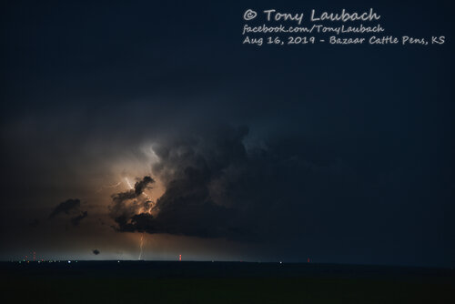
Well, the final round was just beginning, and not long after I went under the toll plaza, those storms that were moving south were dropping CGs at a rate you'd think the world was ending. The show was incredible. Of course, I was stuck on the turnpike with no place to pull over, but I knew, coming up, the Bazaar Cattle Crossing, which has a spectacular view of the Flint Hills in both directions, including south where this insane show was taking place on the backside of these storms. I was getting ready to write my Pulitzer prize acceptance speech thinking I was about to unload the sickest collection of lightning strikes known to man...

Well, Ma-Nature apparently had put out enough, because not one second after I pulled off the highway onto the ramp, those CGs she was so loosely giving away just vanished.. it was like a switch. I didn't even get up the ramp before I would see the last stroke from that blitz. I got parked, set up, and the first frame I took had a strike in it, and I thought okay, she was reloading...

...

...

Nope... she put out three more bolts (I counted) in the 20 minutes I was there. One of those I missed between frames. The other two were meh compared to the show she gave me on my ride down. Thus, I took a consolation prize of the shots I did muster and crumpled up my speech and fed it to a nearby cattle.

19312

19314

19315

So that officially ended my night... I made the hour-plus drive back home, settling into bed victoriously after a very lovely August day. While Colorado has treated me to a few decent August chases in the past, this ranks as my best August chase (outside Colorado). I have only chased twice this August, but have seen tornadoes on both days (I caught a brief glimpse of the rain-wrapped POS near Bethune on Tuesday - no imagery). That said, I am 2 for 2 on tornadoes on those chases.

Can't say there was any real question where the hotspot was going be, and for me, it was just a matter of hanging in viewing area long enough to cut my leash and go. I felt pretty confident early we were going to have capping concerns further west, but even if we got a storm back our way, I'd like to think it would've performed admirably. :D Regardless, this day worked out wonderfully for me, and I will take great pleasure in the steak I will eat in celebration to which may or may not have originated from the earlier mentioned cattle crossing area :D How bazaar would that be? ;)
 

Attachments

  • bazaar02.jpg
    bazaar02.jpg
    793.5 KB · Views: 0
I also chased the cell that fired near Clay Center, matured south of Manhattan, and produced near Alta Vista. I saw some very nice storm structure and the cell's first brief tornado near Alta Vista but missed the longer-track tornado that occurred just after dusk near Volland. As I was driving to my initial target of Junction City I also caught a beautiful shelf cloud associated with a morning MCS that was moving across southeastern Nebraska into northeastern Kansas.

With the academic year rapidly approaching, I viewed this day as perhaps my last good opportunity to get out and chase this season. I left my home in Jacksonville, IL early in the morning and made it to northeastern Kansas by about noon. The southern edge of the MCS (which would put down the boundary that the Clay Center storm would later fire on) came into view just west of Seneca, so I drove a mile or so north of US 36 and caught a great show as the complex's metallic blue-tinged gust front approached from the northwest. I took both of the following shots at about 12:40 p.m. The first looks northeast, the second southeast.

2019-08-15ks#11.jpg

2019-08-15ks#5.jpg

I then had lunch in Marysville and started the short trip south to Junction City, where I spent a couple of hours waiting at a gas station at the intersection on US 77 and I-70. Excellent nowcasting from Colin Davis convinced me to stay put until the Clay Center storm went up to my northwest. Once it looked viable on radar I moved back north on US 77 and positioned a bit east of the storm near the junction with US 24. Here's what the maturing storm looked like near Riley - with a constant rumble and crackling with CGs. This shot looks due west from just north of US 77 and 24:

2019-08-15ks#15.jpg

Brett mentioned in his report above the considerable navigational challenges that this storm presented early on. I realized at this point that II too was going to have move around Fort Riley and then through the city of Manhattan before I could reach KS-177 and get south of the storm. This bit of repositioning didn't take as long as I had feared, and soon I found myself back with a visual of the storm from 177 near I-70. I continued heading south on 177 toward Alta Vista, making several stops to photograph the storm, which was still to my northwest and beginning to wrap up into a nice mothership supercell. Here's what the storm looked like from 177 south of the interstate. The view here is to the northwest:

2019-08-15ks#2.jpg

The storm then became tornado-warned just before I reached the intersection of 177 and KS-4, and soon afterwards I was able to catch a very brief funnel cloud off to the northeast of Alta Vista:

2019-08-15ks#1.jpg

The storm was beginning to get east of me by this point, so I opted to catch back up by driving east on KS-4. The storm continued to show some great structure, but daylight was fading fast. Here's the last good shot of the storm that I was able to get. I took this at 8:25 p.m., which would have been 15 minutes or so before the storm produced a longer-track tornado just east of Volland. This looks north from KS-4:

2019-08-15ks#16.jpg

I then lost light completely as I approached a northern jog in KS-4 well before its intersection with KS-99. Lightning illuminated the storm's base just to my northeast, but unfortunately I failed to see - or capture on my dashcam - the storm's second tornado. I then called it a day, getting back to Junction City just before a powerful trailing cell unleashed on my hotel.

Barring a good Fall setup or two, this was an excellent end to a very satisfying chase season for me. I might also note that while there were a fair number of chasers on this storm, it was not even remotely like the madness I encountered in May in Vigo Park, Mangum, and Lamar.
 
Back
Top