Quincy Vagell
EF4
This was one of my favorite storm chases of the year.
I started the day with a target near the CO/NE/WY border area. By early afternoon, I was not thrilled to see winds shifting/veering. To the east (closer to the CO/NE/KS border), the lower levels looked much more favorable for surface-based, rotating storms, but convective initiation (CI) was much more uncertain. After multiple failed attempts at CI over Weld and Morgan counties, I decided to head southeast.
Southeast of Sterling, I wandered about to check out some sunflower fields. Orphan/sheared out updrafts dotted the sky to the west, while the eastern sky was full of mid-level clouds. Seemingly out of nowhere, some agitated cumulus erupted and seemed to punch through the cloud deck and by 23z (later than model progs, unlike the day prior), it looked like a robust supercell was managing to form along a boundary (moisture gradient/quasi-dryline), just west of Wray.
I zeroed in on the storm relatively quickly. Dropping south of Eckley, I had an up close view of what appeared to be an ill-defined, but rotating wall cloud. I almost got too close for comfort, as the storm was dropping stray golf ball hail on me, while looking toward the east (directly beneath the hail core), I could see large chunks of ice darting to the ground, likely tennis ball size or larger, only about a couple of hundred yards away.
The roads were iffy for a while and despite a relatively favorable grid network, many of the roads were saturated from the day before (this was only a few miles away from the twin tornadoes on the 13th) and/or were awfully sandy to be taking a risk with in a two wheel drive car with very large hail and strong winds in the vicinity. I made it to US-36 unscathed and took a momentary break to plan my next move.
What was an initial, discrete storm, evolved into a cluster of splitting supercell structures. Much like the chase the day before, down the same exact roads, in fact, my goal was to get south to I-70 for a look at the storms from the south side. The storm tracks were similar to the 13th and it also reminded me of my July 29th chase, meaning that on three chases in a row, I was more or less taking the same roads south of I-70. While this gave me an advantage to knowing which dirt roads were navigable, I still had to be very cautious about a few washed out areas. Once I made it by those, it was smooth sailing south.
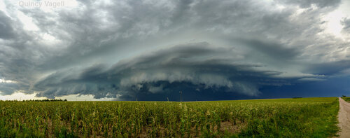
Realizing that the boundary layer T/Td spreads were a bit too large for a more apparent tornado threat, my goal was to focus on capturing storm structure. I knew I had to get back to Norman, OK the next day, so if this storm didn't pan out, I could get a head start on going home. Not only did this storm continue, but it went on to scale the far eastern side of Colorado, making it all the way to the Oklahoma panhandle, before eventually dissipating.
I stopped along the way, multiple times, to capture an intense supercell that was no doubt continuing to produce very large hail. The chase reached a climax around sunset, when I was able to photograph the supercell, as mammatus started to fill the sky between the storm and the setting sun, near Cheyenne Wells.
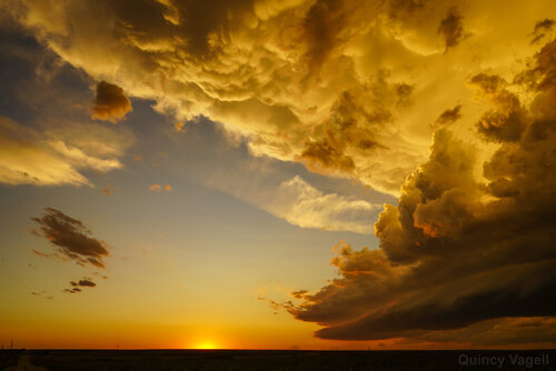
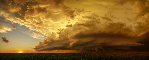
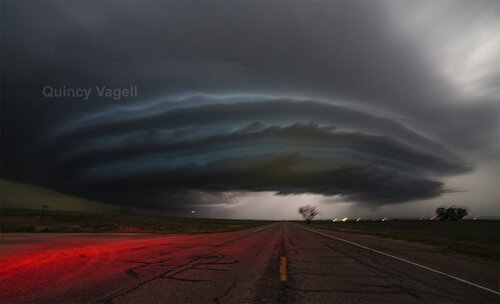
This striated supercell was not letting up, but with daylight fading and a long drive ahead of me, it was time to bail south. I was just a few moments too late to be able to drive into Cheyenne Wells, unless I wanted a smashed windshield, so I looped back around west to take the road south of Kit Carson. As I did so, the supercell split again and I had a visual on a pair of supercells to the east, illuminated by each flash of lightning.
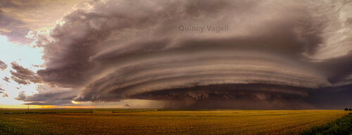
At Lamar, I took a turn east and decided to set up one final intercept before the night was over. I'll admit, nighttime photography is an area that I need more work/practice in, but I was able to capture this following image near Granada, of an intense supercell, that went on to go tornado-warned. Even though the storm was clearly elevated in nature, it was a bit surreal to watch such an intense, rotating storm in darkness.
After all of the excitement, I made the smart decision to not drive straight back to Oklahoma, instead taking a brief stop in Liberal, KS to nap, before ending a very eventful two days of somewhat impromptu storm chasing in August.
Even though this chase failed to produce any tornadoes, in terms of photo opportunities, I played it much better than the day before. Even though the tornado near Joes on the 13th was photogenic in its own right, there was little if any noteworthy storm structure, outside of the tornado itself. On the 14th in the same general area, the supercell of note was (subjectively) among the most photogenic storms of the year that I have had the ability to chase. Late season chasing often goes underrated. It may be August, but with discrete supercells within a strongly sheared environment with few if any other chasers around, it's a type of chasing I thrive off of.
I started the day with a target near the CO/NE/WY border area. By early afternoon, I was not thrilled to see winds shifting/veering. To the east (closer to the CO/NE/KS border), the lower levels looked much more favorable for surface-based, rotating storms, but convective initiation (CI) was much more uncertain. After multiple failed attempts at CI over Weld and Morgan counties, I decided to head southeast.
Southeast of Sterling, I wandered about to check out some sunflower fields. Orphan/sheared out updrafts dotted the sky to the west, while the eastern sky was full of mid-level clouds. Seemingly out of nowhere, some agitated cumulus erupted and seemed to punch through the cloud deck and by 23z (later than model progs, unlike the day prior), it looked like a robust supercell was managing to form along a boundary (moisture gradient/quasi-dryline), just west of Wray.
I zeroed in on the storm relatively quickly. Dropping south of Eckley, I had an up close view of what appeared to be an ill-defined, but rotating wall cloud. I almost got too close for comfort, as the storm was dropping stray golf ball hail on me, while looking toward the east (directly beneath the hail core), I could see large chunks of ice darting to the ground, likely tennis ball size or larger, only about a couple of hundred yards away.
The roads were iffy for a while and despite a relatively favorable grid network, many of the roads were saturated from the day before (this was only a few miles away from the twin tornadoes on the 13th) and/or were awfully sandy to be taking a risk with in a two wheel drive car with very large hail and strong winds in the vicinity. I made it to US-36 unscathed and took a momentary break to plan my next move.
What was an initial, discrete storm, evolved into a cluster of splitting supercell structures. Much like the chase the day before, down the same exact roads, in fact, my goal was to get south to I-70 for a look at the storms from the south side. The storm tracks were similar to the 13th and it also reminded me of my July 29th chase, meaning that on three chases in a row, I was more or less taking the same roads south of I-70. While this gave me an advantage to knowing which dirt roads were navigable, I still had to be very cautious about a few washed out areas. Once I made it by those, it was smooth sailing south.

Realizing that the boundary layer T/Td spreads were a bit too large for a more apparent tornado threat, my goal was to focus on capturing storm structure. I knew I had to get back to Norman, OK the next day, so if this storm didn't pan out, I could get a head start on going home. Not only did this storm continue, but it went on to scale the far eastern side of Colorado, making it all the way to the Oklahoma panhandle, before eventually dissipating.
I stopped along the way, multiple times, to capture an intense supercell that was no doubt continuing to produce very large hail. The chase reached a climax around sunset, when I was able to photograph the supercell, as mammatus started to fill the sky between the storm and the setting sun, near Cheyenne Wells.


This striated supercell was not letting up, but with daylight fading and a long drive ahead of me, it was time to bail south. I was just a few moments too late to be able to drive into Cheyenne Wells, unless I wanted a smashed windshield, so I looped back around west to take the road south of Kit Carson. As I did so, the supercell split again and I had a visual on a pair of supercells to the east, illuminated by each flash of lightning.

At Lamar, I took a turn east and decided to set up one final intercept before the night was over. I'll admit, nighttime photography is an area that I need more work/practice in, but I was able to capture this following image near Granada, of an intense supercell, that went on to go tornado-warned. Even though the storm was clearly elevated in nature, it was a bit surreal to watch such an intense, rotating storm in darkness.

After all of the excitement, I made the smart decision to not drive straight back to Oklahoma, instead taking a brief stop in Liberal, KS to nap, before ending a very eventful two days of somewhat impromptu storm chasing in August.
Even though this chase failed to produce any tornadoes, in terms of photo opportunities, I played it much better than the day before. Even though the tornado near Joes on the 13th was photogenic in its own right, there was little if any noteworthy storm structure, outside of the tornado itself. On the 14th in the same general area, the supercell of note was (subjectively) among the most photogenic storms of the year that I have had the ability to chase. Late season chasing often goes underrated. It may be August, but with discrete supercells within a strongly sheared environment with few if any other chasers around, it's a type of chasing I thrive off of.

