2019-05-06 REPORTS: KS

Joined
Mar 2, 2004
Messages
2,369
Location
Northern Colorado
59543002_10156404596536279_6234343792640524288_n.jpg


Does it count as chasing when the storm you're on stays pretty much in the same 20-mile bubble for five hours? Cause that's basically what happened here.

Targeted the area around of Larned and ended up pitching camp in Pawnee Rock (northeast of Larned) where this storm was given birth to. I basically drove a total of 37 miles from the storm's inception til I finally called it a night, staying within a circle from there over to US-281 (never got that far east), down to US-50, and over toward Lewis/Garfield.

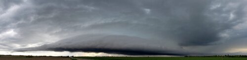
The storm was a prolific hail-producer, but given it's stationary/near-stationary lack of movement, I opted not to go core punching and stayed outside the storm's core to enjoy structure and watch for any potential tornado development. Well as the evening drew on, the lightning and colors got spectacular, so I put away the video and started shooting stills. This was the best of the group by far, but had several others that were pretty good as well.

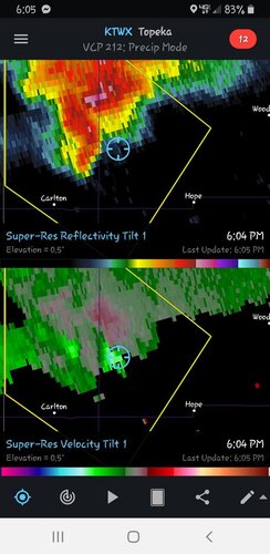
Darkness fell, the lightning got a little-less spectacular, and I was considering calling it a night. About this time, my Chief Met, who had a wider eye on the radar back at the studio, informed me of an area of interest about 15 miles to my west over near Garfield. I re-positioned and initially was unimpressed with the area of interest.

There were a few CGs popping down, so I threw the camera back on the tripod and tried to capture a few bolts. One shot, I noticed what I thought was a funnel/tornado, but too dark to tell. I watched the storm and started thinking, hmm, this could be.

So I cranked up the ISO to 2000 on my Nikon, set the f/stop to 5.0, and at 1/2-second exposures, took handheld zoomed shot on the feature, bracing the camera on the driver-side mirror, and as I was shooting, the funnel fully condensed, and there I was photographing a lightning-illuminated tornado north of Lewis. This was around 9:45pm. The middle picture, the multi-vortex, was toward the end of it's life-cycle (or at least the end of where I could see it). The final picture was likely when it was at its highest intensity. Another hand-held, half-second exposure shot. All three are from a series of 1/2-second exposed photos I shot during the tornado's life-cycle.

59515477_10156404980296279_2298241213452517376_n.jpg


59613013_10156404980371279_8109097236387856384_n.jpg


59937926_10156404980266279_4792546524326264832_n.jpg


I think it lifted (or at least I lost visual) within a couple minutes after I first spotted it. It never made it to US-50, and in fact, the storm, which started to push south, almost retreated back north. It tried to spin-up a couple more times, but I don't think it put down another. Eventually, the bow-echo from the west came in and munched the storm.

I'm not a nighttime chaser usually... obviously I love doing lightning, but rarely do I go out of my way to get on a tornado after dark. This storm was stationary and just right up the road, so it was worth the jog over. It is easily the best nighttime tornado photo I've taken, and I am amazed the camera got it in such great detail. This won't change my view of nighttime chasing, considering in over two decades, this is my best (a 1-in-20+ year deal).

Really it seemed like a pretty under-whelming day as a whole given the previous day's output and expectations going in to this one, but boy was it worth it when all was said and done. Not exactly how I planned to get a wall-hanger, but I'm thrilled with the result.
 

Attachments

  • 20190506_TonyLaubach_Larned.jpg
    20190506_TonyLaubach_Larned.jpg
    92.5 KB · Views: 0
This is a report for Monday, but not in the usual sense. I positioned about 10 miles W of Johnson City KS on US 160 and watched an approaching storm, which I didn't expect to be very interesting until it reached some better parameters around dusk. I found a high spot by driving a little gravel driveway over some RR tracks.

The time came to head E. About 2 miles later, I had a flat tire. I must have driven over something by those RR tracks. I pulled over onto some dirt, the only safe spot I could quickly find. My jack wouldn't work on the dirt, and I called AAA, and they dispatched a tow truck from LAMAR CO!! (About 100 miles away)

Well, I got out of there and checked into a motel in Ulysses at 11:30, clothes muddied. I will be carrying a hydraulic jack with me from now on. I have a new motto.

"Don't call it mud. It's patina."
 
This chase trip was characterized by multiple equipment failures. Early in the day, my GPSGate software stopped working after I had reconfigured the cabling in my vehicle. The issue was a software licensing problem triggered by switching the USB port of the puck. After that was fixed, I resumed the trek west.

I started the chase from Abilene, Kansas right on the stationary boundary. It was more like a weak cold front sagging south. This movement increased as two storms developed to its north, and the boundary raced south across I-70 through Abilene with the push of outflow. I didn't expect the storms to catch up to the boundary, deciding to start heading west to where the front would be more stable. At that point, the lead storm did catch up to the front near Junction City, but I was too far west and out of position.

I dropped southwest to new storms south of the boundary, one of which had some nice structure near Assaria. As I made this move, my main chase power circuit dropped out completely. I lost all dashcams, chargers and laptop power. During the stop to troubleshoot, I received a call from a chaser friend, and in the chaos of attending to both the conversation and the repairs, set my phone down on the trunk of the car. I finally determined the cause of the failure, it was my Startguard UPS unit that protects the circuit from voltage drops during cranking the engine. The fuse was OK, so the unit must have failed. I bypassed the Startguard and was up and running. About 20 minutes later, the power flickered and dropped again! This time, it was my main on/off dashboard switch for the power circuit, the contacts had physically failed. This might have been going on for some time, which could have been what fried the Startguard. I removed the switch, connected the two leads with a wire nut and was back on the road.

The storm at New Gottland intensified rapidly, and I positioned in the notch of the storm. I observed strong RFD (descending motion) but no countering surface inflow. My car took a pounding from tennis ball sized hail here, but all windows survived thanks to the hail guards. I moved ahead of this storm to try and capture some of the lightning in the vault region, grabbing a couple of bolts in high speed.

may619a.jpg

I moved south to intercept additional storms, but none were able to become as organized. After some more failed lightning attempts, I got a hotel in Wichita and arrived at 11:00pm. As I got all of my gear together to take inside, discovered my phone still sitting on the trunk hail guard. It had miraculously not blown off, but was soaking wet from several downpours and probably several major hail impacts. I removed the battery, took it inside and set it in front of a fan overnight. In the morning, I powered it up, and it works. The screen is splotched but still operational.

Video from this day includes the high speed lightning video along with a dashcam timelapse of the Assaria storm:

 
Last edited:
We could only make it out for one day, so Salina (from St. Louis) was about as far as I was willing to venture. Made it there shortly before storms began to form just to the north of I-70 near Salina and Abilene. As Dan mentioned, the boundary was sagging southward, which may have been aided by outflow from a storm a little further to the north. The new storms' outflow didn't help things, and they too ended up being on the wrong side of the boundary. The westernmost one tried to stay on the boundary for a little while and looked decent before losing the battle with its outflow and boundary:

IMG_0716.JPG
IMG_0723.JPG

The easternmost storm had caught up to the boundary, so we tried to move ahead of it. We probably would have made it, but after having to pass through a few small towns, getting stuck behind a semi in a series of no passing zones, and a horrendous construction zone, we had just enough time to race it to I-35. It looked pretty wicked, but we were unable to stop for photos. I knew my dash cam was capturing it...until later when I found that the video files had been overwritten due to an error on my part. We were able to stop briefly and get a couple shots of the shelf cloud along its forward flank before making our way back home:
IMG_0749-Pano.JPG

More photos and details here: www.thunderheadscenicphotography.com/may-6-2019-log.html
 
This was my travel day from west-central Illinois to the Texas panhandle, but I got on the road early enough to be able to catch two nicely structured supercells between Salina and McPherson, Kansas as a cold front slowly dropped to the southeast. It appeared that the Garden City area would be best positioned for severe storms this day, but I knew that was too far to the southwest for me to reach, so I hung out on the west side of Salina near I-135 for a couple of hours and hoped for the best.

After about 4 p.m. the front slowly began to unzip from the Abilene area, with the southern and western-most cell firing near Ellsworth, KS. The storm was moving very slowly to the east, so I had no problem dropping down I-135 to the Assaria exit, where I then drove a few more miles west toward the small town of Falun, KS. It was downright chilly - about 65 deg - as the storm approached from the west, so my expectations were pretty low. But before the storm began to croak after ingesting this cold air, it briefly put on the quite display for me. These two photos look west from about a mile north of Falun:

2019-05-06#1new.jpg2019-05-06#2new.jpg

I then opted to move a bit further into the slightly warmer air south of the front where another initially elongated cell had fired to the northwest of McPherson. I exited the interstate at Mohawk Road, found a good gravel parking lot, and for the next 45 minutes was delighted to watch this storm slowly organize to my northwest while remaining almost stationary. I shot a lot of stills and some video as the storm crawled toward me. Here's a three-shot sequence of the storm's gradual development over the course of about half an hour:

2019-05-06#3new.jpg2019-05-06#4new.jpg2019-05-06#5new.jpg

Eventually the storm overtook my position, so I packed up and headed a bit further south on I-135 and then a couple of miles east on US 56. The storm's radar signature wrapped up nicely at this point and soon became tor-warned, but it was too little, too late. The cell was quickly undercut by the cold front, and the show was soon over.

By this point another cluster of storms to my west in the Larned, KS area was beginning to mature nicely (and later produced), but I opted to call it a day and got a room in Wichita for the night. With the exception of two other chasers who joined me near McPherson for a few minutes, I was completely alone with these two photogenic storms - a far cry from the huge number of chasers I would find myself in the midst of during the Tulia, TX storm the next day.
 
This was the first day chasing this season and what I had hoped would be the first of 3 days in a row chasing. My chase partner and I left Omaha and initially thought we would head towards SW KS and maybe even cross into Colorado. We were initially a little unimpressed with the tornado chances and thought we would target that area for the more sure chance of at least storms.
We were making good time and drove all the way to Dodge City, before deciding to stop and reassess things. At this point there were storms up in northeast Kansas and in SE Colorado with nothing in between. However, there was at least a chance of something forming between 6-7 back to the northeast, so we meandered back to around the Larned, KS area.
Finally a storm got going around 630 I believe, just to our south. It was cool to watch it go up from a small tower into a good sized storm with a nice base. Storm motions were slow and it was drifting off to the east. A wall cloud eventually formed and it looked pretty nice for a while, but meanwhile back to the west/southwest another more impressive cell formed so we ditched the first one and went back to the southwest.
We found a nice spot to the east of the storm as it was now after 8p and getting darker. The lightning with this storm was intense as Tony's pics above show. We figured this was a good place to shoot lightning and let the storm come to us, but it never did as the storm was basically stationary and had even begun drifting south.
We made our way south to Hwy 50 and then headed west to Belpre and went north on Hwy 19 a few miles. The storm was looking good on radar. At this point it was dark, so we just sat on a gravel road and watched it throw out constant lightning. Finally a tornado warning was issued for it so we went back south to Belpre and went west a couple more miles and found a place to look west that was a little closer to the storm. The storm had a nice base and near constant lightning so we could see pretty well. I had my video camera out with my window down as we sat in our vehicle. Not more than 5 minutes later I would say, the storm finally dropped a tornado! This was my first nighttime tornado so it was pretty neat to finally catch one and the video turned out pretty good. I normally don't chase after dark, but we didn't have to get home since we were chasing the next day so it worked out awesome. The tornado looked like it lasted maybe a minute or two and at this point the storm was getting slowly closer. Once it lifted we figured we would start heading south to Oklahoma where we were staying the night in Woodward. Pretty sure the storm dropped another tornado thereafter as the velocities looked crazy again. Despite the late start to the day for initiation, it ended up being a great first chase of 2019.

Here's my video of the tornado:

wall cloud.jpg

storm1.jpg


storm2.jpg
 
I had to meet people in Kansas City for the long drive to Amarillo the next day so I went to Salina area to chase. I got on the cell that tracked into Salina then dropped south to the next one. It started to look very good south of Abilene as seen by the radar image below but never did much after. The below photos are of the cell drying, some mammatus and a cool rainbow over Lawrence. Not a bad short chase but I missed the good stuff further SW.
 

Attachments

  • 1.jpg
    1.jpg
    61.4 KB · Views: 0
  • 2.jpg
    2.jpg
    65.4 KB · Views: 0
  • 3.jpg
    3.jpg
    37.4 KB · Views: 0
  • 4.jpg
    4.jpg
    97.2 KB · Views: 0
Back
Top