• While Stormtrack has discontinued its hosting of SpotterNetwork support on the forums, keep in mind that support for SpotterNetwork issues is available by emailing [email protected].

2019-04-30 REPORTS MO/IL/OK/TX/KS

As Oklahoma was too far of a drive for a very sketchy looking setup, I chose to stick with the local warm front play in Illinois.

I set up in Litchfield like many other local chasers and shot down south to intercept the supercell that would eventually produce a tornado just southeast of Hamel. I didn't really get much in the way of footage or photos from this particular chase, but I was at least able to hastily snap an image of the Donnellson tornado in it's dying stage. Opting to try to gain ground on the storm by heading east to get clear of the lake near Donnellson thinking I had time as the supercell was still struggling quite a bit with being outflow dominant, but this ended up backfiring on me as that's when the storm decided to produce. Figures. Otherwise this storm was a prolific positive CG bolt producer and a sight for sore eyes after having chased very little so far this season.

Regardless this is my first tornado of the 2019 chase season, and my first April tornado period so I'd say mission accomplished.
 

Attachments

  • 5fa77fd390b520818587c1db703a9a9f.jpg
    5fa77fd390b520818587c1db703a9a9f.jpg
    207.6 KB · Views: 0
I chased the the long-lived supercell from near its start in St. Louis (first intercept in Sunset Hills, MO) to near Effingham. I stayed in the inflow notch for most of the way, and had a good visual on updraft/RFD features during that time. The storm suffered from severe undercutting for most of its life, but somehow managed to produce between Donnellson and Coffeen, IL. I went as far as Martinsville, IL for additional storms near the warm frontal zone, but didn't see any other serious attempts at organization. Still out shooting lightning and likely will be all night!

april3019b.jpg

Edit: captured some nice bolts on high speed - here is the video of that and the tornado:

 
Last edited:
I hung out at home in Oklahoma City through lunchtime, as my effective starting target, watching chasers post footage of a rare, midday tornado near Sulphur, OK. A short time later I left, but wasn't quite sure what direction I wanted to go.

I initially thought that I would go east of I-40 and catch storms moving in from the south, but I scrapped that idea fairly quickly, after noting that conditions in southwestern Oklahoma were rapidly becoming quite favorable for tornadoes. I'm also not too fond of chase terrain east of I-35 in Oklahoma. It was a toss-up between taking I-44 and I-35, but I initially went south and ended up cutting over west from Ardmore. I figured that if I took I-44, I might overshoot the setup too far to the west.

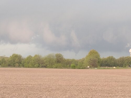
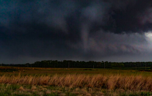
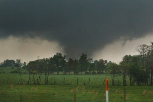
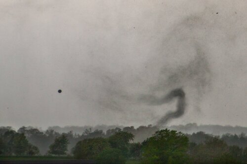
When a storm near Wichita Falls was wrapping up on radar, I dropped down into Texas for a closer look. Just as I got into position, a narrow stovepipe tornado could be seen to the west, just north of Dean, TX, as of 4:35 p.m. I took a dirt road west to get off the main road and when I stopped, I saw what looked like two tornadoes, although I am not 100% sure that the funnel on the right was fully condensed to the ground. It was the tornado on the left of this image which was the first tornado I saw during this chase.
twins_190430.jpg

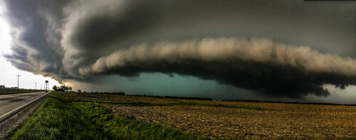
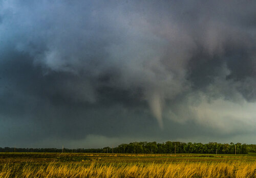
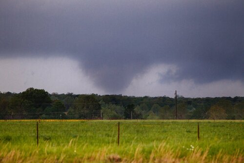
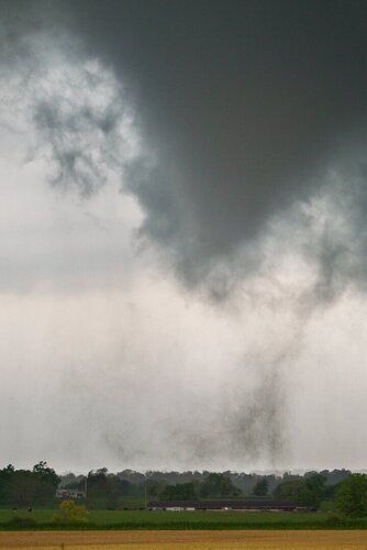
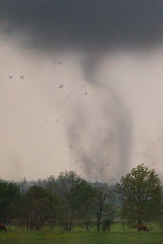
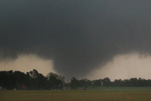
A few minutes later, the lowering on the right was clearly a tornado in progress. This tornado skipped up and down for about the next 15-20 minutes. At my closest pass, four miles northwest of Petrolia, TX, I watched the tornado kick up some debris, become a bit wider and ultimately transition into a rain-wrapped mess, out of sight. I lost view of the tornado around 4:57 p.m. Based on radar data, this tornado probably ended just before reaching the Red River, but I cannot concretely confirm that.

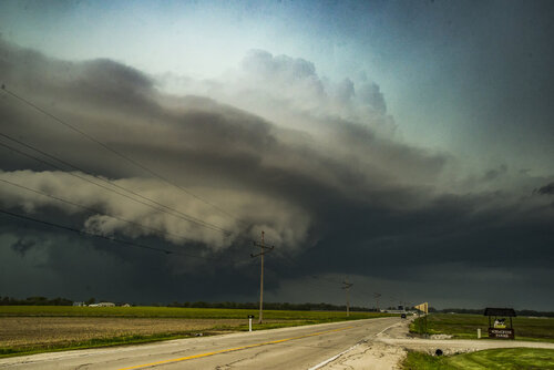
That was pretty much all that she wrote for this chase. I followed the previously tornadic supercell into Oklahoma, but it started to weaken and was eventually absorbed by a broken line of storms. I went east in hopes to maybe catch some warm sector supercells, but convective modes were messy and I didn't witness any discrete supercells after the initial one in Clay County, TX.

Overall, this was my best tornado chase in April, since I started chasing the Plains in 2014. I witnessed two separate tornadoes for about 20 minutes and although I did not manage to get many photos or high quality video, that does not matter too much. I stood in awe watching a tornado over open land for the first time since 2017. The two tornadoes that I saw that year were very brief and either from a distance or very low contrast. With new camera gear this year, I'll consider this a practice run and I'm ready to see what May and beyond has in store.
low_res_grabs.jpg
 
Last edited:
I chased South Central IL today leaving Macomb around 11am and arriving in Litchfield shortly after 1:30pm for a bite of lunch and a lookover weather data. I was pretty disappointed to see the "junky" nature of the storms and the surging outflow, but nonetheless, I'm here so I might as well give it a shot. I got on the long lived St Louis supercell as it traveled northeastward. My first shot was near the town of Alhambra, IL around 2:55pm. It went tornado warned shortly after, where I got into the notch of the storm and noticed an attempt at tornagogenesis, there may or may not have been a brief spin-up here....I'm not going to count it. I followed the storm east and eventually northwest toward the town of Donnellson, IL In between this, we got into some golf ball size hail while again in the notch of the supercell, I feared it possibly getting larger and breaking glass, but thankfully it didn't.

17872

I noted some impressive storm structure south of town, nice HP supercell with an exposed updraft. This probably cost me 10 minutes, pulling over for structure shots, but I drove up the road into the town and watched tree debris go airborne as the wall cloud crossed in front of me.

17873

I pulled eastward down the neareast road on the south side of town and watched as a funnel decended down around 3:50pm. The tornado appeared to last about 2 minutes from my point of view. Dan Robinson was able to confirm ground circulation. Was really quite a nice tornado for a messy storm.

17874

17878

The storm pretty much went into junk mode after that and we headed for home arriving back at my apartment at 9pm after a few stops. Overall it was a solid day of chasing in Southwest IL, I was dissappointed to miss out on the tornadoes in the Plains, but I think what I saw in IL was up there with some of the other tornadoes today. Some of my shots are included.
 

Attachments

  • IMG_6070 copy.JPG
    IMG_6070 copy.JPG
    320.8 KB · Views: 0
  • DSC_9004 copy.jpg
    DSC_9004 copy.jpg
    238.9 KB · Views: 0
  • DSC_9036 copy.jpg
    DSC_9036 copy.jpg
    306.7 KB · Views: 0
  • DSC_9041.jpg
    DSC_9041.jpg
    229.5 KB · Views: 0
While yesterday as a successful chase with seven tornadoes I had a chaser nightmare happen to me. While “filming” the Stella tornado from ½ a mile away with power flashes and multiple drops I realized after leaving that the 4k camcorder was not actually ON. One of my best ever videos never happened so depressing. All I have of any video is this blah cell phone video later in the cells life from way further back and closer to Wheaton. I do not have to dream this nightmare I now have experienced it.

https://www.youtube.com/watch?v=JgwcgTGKHKo&feature=youtu.be
 
I do not understand how conditions can be favorable for a lone open warm sector storm to form, drop a tornado, and conditions also be favorable for that storm to quickly die and no other storms form. So much to learn. I was in the right area but missed the Sulphur tornado buy 15 minutes or so. I hung around there for another hour or two hoping for another storm but finally decided to head West. Noticed the storm out ahead of previous convection so decided to target it. Made it there barely in time after missing my turn for the bridge across the Red River at Waurika OK. Was able to view the torn20190430_165410-1-1.jpg

ado from probably 5 miles away. Fun watching it for probably 10 minutes before it wrapped up in rain as a solid looking stove pipe. Also saw the best scudnado I have ever seen... the picture taken off my video cam screen.
20190501_104348.jpg
 
Here are some outstanding photos by Allison Marshall that was chasing with he yesterday of the Wheaton and MO tornadoes
 

Attachments

  • 1.jpg
    1.jpg
    259.6 KB · Views: 0
  • 2.jpg
    2.jpg
    253.1 KB · Views: 0
  • 3.jpg
    3.jpg
    75.2 KB · Views: 0
  • 4.jpg
    4.jpg
    235.6 KB · Views: 0
  • 5.jpg
    5.jpg
    110.1 KB · Views: 0
  • 6.jpg
    6.jpg
    248.8 KB · Views: 0
  • 7.jpg
    7.jpg
    311.2 KB · Views: 0
  • 8.jpg
    8.jpg
    292 KB · Views: 0
Opting to play the warm front in southwestern Illinois, this was the first real chase of the season for me. I left home in Jacksonville, IL about noon for an easy hour and a half drive south to Litchfield, IL, where I had a good time waiting with four other Central Illinois chasers for a messy line of storms over St. Louis to move east, cross the Mississippi, and interact with the warm front. The eastern-most cell in this complex matured rapidly over the Edwardsville, IL area and once it became severe-warned and hooked up a bit, all of us realized that we needed to get south as quickly as possible.

My initial approach to the approaching storm was thwarted by a malfunctioning railroad crossing just south of Litchfield, so I opted for a somewhat longer route that involved heading east to Hillsboro, IL and then south on IL-127. I was able to duck just south of the cell's precip core near Donnellson, IL, where I had to wait but a couple of minutes for the increasingly elongated storm to reach me. This photo looks to the northwest from about two miles south of Donnellson from IL-127:

2019-04-30#1.jpg

I then cautiously moved a bit back north up IL-127, stopping again in a gravel lot about a mile south of Donnellson. Looking north at 3:58 p.m., I caught a brief glimpse of the tornado documented above by Dan, Ethan, and Devin before rain and clouds obscured my view. I then simply opted to let what was now a line of heavy rain and small hail move over me to the northeast. Here's a screenshot I took at the time:

2019-04-30il#6.png

I then headed south on IL-127 to Greenville, IL where I watched the southern-most cell of the complex for a bit before calling it a day and heading home. This setup was certainly an easy and at times exciting way to shake off the rust and ease into the chase season.
 
We chased along the warm front draped across the St. Louis area and southern Illinois. Was a little discouraged at first seeing as the warm sector storms that developed quickly became messy and seemingly disorganized ahead of a surging outflow boundary from a decaying MCS to the west of St. Louis. Once one of the storms began to interact with the warm front, it organized and intensified into a pretty beastly HP supercell around Alhambra, IL:
IMG_0634.JPG
IMG_0655.JPG
It started to mix with convection to its south and weakened somewhat. Instead of heading north toward Donnellson, we went east a little to give it room. Here's our view of the storm 5 miles away right around the time of the reported tornado:
IMG_0675.JPG

Additional images and details here: April 30, 2019 Log
 
Back
Top