Quincy Vagell
EF4
Far from a high-end day, but this is my last extended vacation (other than one-offs) of the chase year, so I started the trip by targeting eastern Montana earlier today.
The high resolution models in the short term were very inconsistent with convective details, but were in agreement that the parameter space would be most favorable for supercells from southeastern Montana into western South Dakota. Any time you have 40-50+ knots of deep layer shear with at least modest instability and dew-points well into the 50s in the High Plains, it's hard to argue against chasing, if one has the opportunity. Even if 500mb heights were rising a bit today...
Setting up for the chase was a little bit sloppy. I started the day in southern Wyoming and had a relatively long drive north to get into position. After making it to Broadus, I noticed a fairly healthy updraft well to the north, so I bolted in that direction. As a general rule, I take ground verification (my own eyes) over radar, and with limited data, I initially hopped on the first tower. It wasn't long before I realized that was a fairly dumb move given drier air (dew-points in the 40s) up there and an unfavorable environment downstream. Even though your eyes are great, the other big argument here is that when you have two near-term north-south targets, favor the southern target, especially if the parameter space is better there.
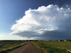
Large hail-producing supercell just north of Belle Fourche, SD.
Long story short, the southern cluster of cells would go on to become a long-tracking supercell (at least 200 miles as of the time of this post). Storm motions were very manageable, so despite the early misplay and a very limited road network in southeastern Montana, I got back on track in northwestern South Dakota to close in on the intensifying supercell. Cloud bases were very high from the start (2-2.5km) and even with somewhat better low level moisture and lower LCLs in South Dakota, marginal low-level shear precluded a more notable tornado threat. With that said, this storm was a proficient hail producer, with a lot of damage reported near Newell.
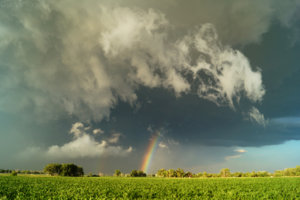
A rainbow near Vale, SD, as the storm is producing large to very large hail.
While my original plan was to head to Newell immediately after the storm passed to inspect damage and hail size, I opted to go south for more of a structural play. I'm not a big fan of documenting storm damage anyway and didn't want to get in the way of any cleanups/recovery/etc.
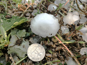
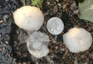
I did sneak over to Vale (one town south of Newell), briefly, but I quickly ran into a patch of road that was littered with leaves, twigs and some larger branches, a good reminder that I'd be better off avoiding storm damage. I got out of my car and saw hail of up to at least 1.75 inches in diameter. I only stopped briefly for a couple of pictures before darting back south to get into position for structure photos.
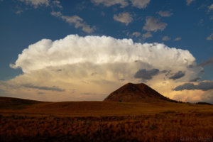
Near Sturgis, I liked the terrain that I was seeing and thought it would line up nicely with the departing supercell, to close out the chase. I toyed with several different angles and lenses, but the below photo is my favorite of the bunch. It's actually one of my favorite photos from my personal chase collection this year.

The high resolution models in the short term were very inconsistent with convective details, but were in agreement that the parameter space would be most favorable for supercells from southeastern Montana into western South Dakota. Any time you have 40-50+ knots of deep layer shear with at least modest instability and dew-points well into the 50s in the High Plains, it's hard to argue against chasing, if one has the opportunity. Even if 500mb heights were rising a bit today...
Setting up for the chase was a little bit sloppy. I started the day in southern Wyoming and had a relatively long drive north to get into position. After making it to Broadus, I noticed a fairly healthy updraft well to the north, so I bolted in that direction. As a general rule, I take ground verification (my own eyes) over radar, and with limited data, I initially hopped on the first tower. It wasn't long before I realized that was a fairly dumb move given drier air (dew-points in the 40s) up there and an unfavorable environment downstream. Even though your eyes are great, the other big argument here is that when you have two near-term north-south targets, favor the southern target, especially if the parameter space is better there.

Large hail-producing supercell just north of Belle Fourche, SD.
Long story short, the southern cluster of cells would go on to become a long-tracking supercell (at least 200 miles as of the time of this post). Storm motions were very manageable, so despite the early misplay and a very limited road network in southeastern Montana, I got back on track in northwestern South Dakota to close in on the intensifying supercell. Cloud bases were very high from the start (2-2.5km) and even with somewhat better low level moisture and lower LCLs in South Dakota, marginal low-level shear precluded a more notable tornado threat. With that said, this storm was a proficient hail producer, with a lot of damage reported near Newell.

A rainbow near Vale, SD, as the storm is producing large to very large hail.
While my original plan was to head to Newell immediately after the storm passed to inspect damage and hail size, I opted to go south for more of a structural play. I'm not a big fan of documenting storm damage anyway and didn't want to get in the way of any cleanups/recovery/etc.
I did sneak over to Vale (one town south of Newell), briefly, but I quickly ran into a patch of road that was littered with leaves, twigs and some larger branches, a good reminder that I'd be better off avoiding storm damage. I got out of my car and saw hail of up to at least 1.75 inches in diameter. I only stopped briefly for a couple of pictures before darting back south to get into position for structure photos.


Near Sturgis, I liked the terrain that I was seeing and thought it would line up nicely with the departing supercell, to close out the chase. I toyed with several different angles and lenses, but the below photo is my favorite of the bunch. It's actually one of my favorite photos from my personal chase collection this year.
