Dean Baron
Supporter
Just going to do a quick summary since I don't have video or pictures off of my actual cameras yet.
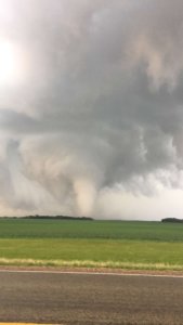
Left work at 3:00 from Minneapolis and headed west. Knew I wouldn't make the triple point in SD but figured the warm front might have a chance to do something. A couple showers must've been riding the warm front as it moved north and one of them finally found a hole in the cap around Montevideo, MN. Got on it before it went tornado warned. Followed it for 2-3 hours up to near Alexandria, MN. The storm had great structure with a big rotating wall cloud but took a long time to finally put down tornadoes. Near Hancock, MN it finally put a few down. I saw 2 myself, the first being a small/brief tornado in a field. Shortly after that, it put down a much bigger/stronger tornado north of Hancock. I've attached a cell phone pic of the tornado. I have HD video as well as multiple pics from the DSLR of it, but I won't have a chance to upload those for a couple days.
Left work at 3:00 from Minneapolis and headed west. Knew I wouldn't make the triple point in SD but figured the warm front might have a chance to do something. A couple showers must've been riding the warm front as it moved north and one of them finally found a hole in the cap around Montevideo, MN. Got on it before it went tornado warned. Followed it for 2-3 hours up to near Alexandria, MN. The storm had great structure with a big rotating wall cloud but took a long time to finally put down tornadoes. Near Hancock, MN it finally put a few down. I saw 2 myself, the first being a small/brief tornado in a field. Shortly after that, it put down a much bigger/stronger tornado north of Hancock. I've attached a cell phone pic of the tornado. I have HD video as well as multiple pics from the DSLR of it, but I won't have a chance to upload those for a couple days.