Quincy Vagell
EF4
We started the day near the CO/KS/NE border and opted to begin the chase on the Colorado side for the early afternoon. Storms started to develop to our north, as we sat near Goodland, but despite a tornado warning being issued, I decided it would be best to hang south, as storm modes were getting messy and a possible tornado report with the convection was likely a landspout.
Storms struggled to organize for a while, but that was pretty much expected for the day. While shear was decent, instability was lower-end and moisture was lacking.
We drifted east I-70 and a cell near the CO/KS border started to show some subtle signs of organization. We stopped, observed broad rotation, but ultimately drifted east to stay ahead of the storm. Watching radar, it was clear that the storm was accelerating and forcing a gust front out ahead, remaining largely outflow dominant.
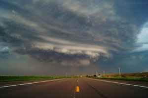
Around the Oakley area, I made the decision to blast south toward convection in southwestern Kansas, given stronger boundary layer heating and, overall, a slightly better parameter space. The initial cell up near I-70 was beginning to look like it was wrapping up, but at the same time, it also appeared to be occluding, or at least wrapping over itself. A tornado warning was issued and we stopped briefly, just to make sure. I didn't think it would be wise to move back north into what was a rain-wrapped circulation, and instead, we stayed south to take some photos. The storm was quickly becoming more photogenic from our vantage point, so there was no point in ruining photo opportunities just to get in the middle of a messy looking tornado warning.

The above photo was taken near Elkader, facing north on US-83. Although I've had some decent chases this year, this chase had some of the better (maybe not quite the best) structure of the year. Perhaps my judgment is somewhat clouded by what was, what I would consider, over-performing structure for the setup, but magical things can happen in western Kansas.
Either way, it wasn't long before we got back on the road south, to check out the Dodge City area. It was a conditional play and I knew that we might not see much of anything at all. A discrete cell was drifting east and radar scans were becoming less helpful as the convection moved right toward the DDC radar site. On satellite, trends were hard to tell, but visually, we could see that the updraft would pulse up from time to time, so we continued on.

After stopping for a few photos just west of Dodge City, our visibility quickly became obscured by some mid-level clouds and the cell steadily weakened. It was at the same time that robust convection to the north was also showing downward trends in organization. Instead of wandering much farther, it made sense to stay in Dodge City, a year and a day after a historic event in the same area, and prepare for the following days chase.
I generally chase solo, but my chase partner for this week is Jackie Lucente, a previous meteorology major at Western Connecticut State University, a long-time friend and co-worker. We started chasing annually in late May in 2014, but she was unable to get out last year. Our trips have consisted of a mixture of leisure travel and chasing (we tend to skip over marginal setups, which sometimes comes back to bite us), and although 2014 and 2015 didn't offer much for our trips, it looks like yesterday's chase will mark the start of a solid 3-4 day stretch.
Storms struggled to organize for a while, but that was pretty much expected for the day. While shear was decent, instability was lower-end and moisture was lacking.
We drifted east I-70 and a cell near the CO/KS border started to show some subtle signs of organization. We stopped, observed broad rotation, but ultimately drifted east to stay ahead of the storm. Watching radar, it was clear that the storm was accelerating and forcing a gust front out ahead, remaining largely outflow dominant.
Around the Oakley area, I made the decision to blast south toward convection in southwestern Kansas, given stronger boundary layer heating and, overall, a slightly better parameter space. The initial cell up near I-70 was beginning to look like it was wrapping up, but at the same time, it also appeared to be occluding, or at least wrapping over itself. A tornado warning was issued and we stopped briefly, just to make sure. I didn't think it would be wise to move back north into what was a rain-wrapped circulation, and instead, we stayed south to take some photos. The storm was quickly becoming more photogenic from our vantage point, so there was no point in ruining photo opportunities just to get in the middle of a messy looking tornado warning.
The above photo was taken near Elkader, facing north on US-83. Although I've had some decent chases this year, this chase had some of the better (maybe not quite the best) structure of the year. Perhaps my judgment is somewhat clouded by what was, what I would consider, over-performing structure for the setup, but magical things can happen in western Kansas.
Either way, it wasn't long before we got back on the road south, to check out the Dodge City area. It was a conditional play and I knew that we might not see much of anything at all. A discrete cell was drifting east and radar scans were becoming less helpful as the convection moved right toward the DDC radar site. On satellite, trends were hard to tell, but visually, we could see that the updraft would pulse up from time to time, so we continued on.
After stopping for a few photos just west of Dodge City, our visibility quickly became obscured by some mid-level clouds and the cell steadily weakened. It was at the same time that robust convection to the north was also showing downward trends in organization. Instead of wandering much farther, it made sense to stay in Dodge City, a year and a day after a historic event in the same area, and prepare for the following days chase.
I generally chase solo, but my chase partner for this week is Jackie Lucente, a previous meteorology major at Western Connecticut State University, a long-time friend and co-worker. We started chasing annually in late May in 2014, but she was unable to get out last year. Our trips have consisted of a mixture of leisure travel and chasing (we tend to skip over marginal setups, which sometimes comes back to bite us), and although 2014 and 2015 didn't offer much for our trips, it looks like yesterday's chase will mark the start of a solid 3-4 day stretch.
Attachments
Last edited:


