
John Farley
Supporter
Days like this are why I love storm chasing/photography in New Mexico! All these pictures were taken within about 30 miles of Santa Rosa. Storm after storm, most of them supercells. And I saw two, maybe three other chaser vehicles all day - in the third week of May! I will get a full chase report for this day written up as time permits. In the meantime, here are a few of my favorite pics.
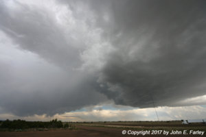
Storm 1, just WNW of Santa Rosa as I approach from the west:
View attachment d5658b6a06bc51c8011d9a7cecbb5627.jpg
This small funnel cloud formed under Storm 1. Never got much bigger than this and didn't last long, so no real threat:

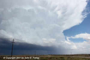
Storm 2 - Left split supercell from a storm that formed southwest of Fort Sumner:

Unlike most left splits, this one became dominant, dropping 2-inch hail as it crossed U.S. 84 moving NE. A little after this, it also absorbed Storm 1, which was moving SE as did most of this day's storms. Here is a picture of the 2-inch hail:
View attachment 8741a421e4b859087795c12fee72e436.jpg
Storm 3 - this began as a line of storms that formed in outflow from the first two, but gradually consolidated into a more cellular structure. It also went severe and dropped 1-inch hail near House, NM:

Storm 4 - LP supercell near Santa Rosa (wide angle shot). Doesn't look like there is much precipitation under the cloud, but a pretty good barrage of 1-inch hail had just fallen from it where I took this picture. Luckily I was under a roof for most of the time the hail was falling:
[Broken External Image]:http://www.johnefarley.com/chase52217-fb5.jpg"
(Note: this one and the next one say "broken external image" but they work when I click on them. Not sure what is going on here, but the links do not really appear to be broken.)
The mammatus in the distance were under the anvil of this LP supercell, well to the southeast.
Storm 5 - the only storm of the day to get a tornado warning (though well after this picture was taken):
[Broken External Image]:http://www.johnefarley.com/chase52217-fb6.jpg"
This is the one that eventually moved east of Roswell. I took this picture from about 40 miles from the storm - that only seems to work in places like NM and CO.
Storm 1, just WNW of Santa Rosa as I approach from the west:
View attachment d5658b6a06bc51c8011d9a7cecbb5627.jpg
This small funnel cloud formed under Storm 1. Never got much bigger than this and didn't last long, so no real threat:
Storm 2 - Left split supercell from a storm that formed southwest of Fort Sumner:
Unlike most left splits, this one became dominant, dropping 2-inch hail as it crossed U.S. 84 moving NE. A little after this, it also absorbed Storm 1, which was moving SE as did most of this day's storms. Here is a picture of the 2-inch hail:
View attachment 8741a421e4b859087795c12fee72e436.jpg
Storm 3 - this began as a line of storms that formed in outflow from the first two, but gradually consolidated into a more cellular structure. It also went severe and dropped 1-inch hail near House, NM:
Storm 4 - LP supercell near Santa Rosa (wide angle shot). Doesn't look like there is much precipitation under the cloud, but a pretty good barrage of 1-inch hail had just fallen from it where I took this picture. Luckily I was under a roof for most of the time the hail was falling:
[Broken External Image]:http://www.johnefarley.com/chase52217-fb5.jpg"
(Note: this one and the next one say "broken external image" but they work when I click on them. Not sure what is going on here, but the links do not really appear to be broken.)
The mammatus in the distance were under the anvil of this LP supercell, well to the southeast.
Storm 5 - the only storm of the day to get a tornado warning (though well after this picture was taken):
[Broken External Image]:http://www.johnefarley.com/chase52217-fb6.jpg"
This is the one that eventually moved east of Roswell. I took this picture from about 40 miles from the storm - that only seems to work in places like NM and CO.
Attachments
Last edited:


