kevin-palmer
EF2
I finally have my first storm chase of the year under my belt. After busting on Saturday, I was hesitant to pull the trigger again on Monday. But it became apparent that the wind shear (especially in the low levels) and instability was much more favorable than it had been 2 days earlier. Plus with the GFS showing nothing of interest in the Northern Plains for the rest of the month, I knew I had to go.
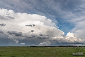
My initial target was south of Newcastle, where the HRRR was showing some long track supercells developing. Minutes after hitting the road at 2:30, I watched a storm develop over my head near Buffalo. The updraft was looking very crisp and I was tempted to go after it. But I knew I wouldn't be able to track it for very long with few road options, so I let it go. When I reached Moorcroft, I stopped and reconsidered my target. Cloud cover was delaying storm development to the south. To the north, a new severe thunderstorm warning was issued for large hail. This was the original cell I saw earlier. There is no radar coverage in this part of Wyoming, so when it disappeared from view there was no way for me to know what it was doing. But I soon realized it was heading for Devil's Tower, and I knew this was a photo opportunity I couldn't miss. The storm was a slow mover, stationary at times and never going faster than 25 mph. This gave me plenty of time to approach it.
The cell passed 10-15 miles north of Devil's Tower and my vision of a mothership over the tower didn't quite pan out.

Devil's Tower Supercell by Kevin Palmer, on Flickr
But I still had plenty of time to get closer north of Hulett. I lucked out in finding a paved road, Highway 112, that took me right up to the edge of the hail core, where I stopped. Earlier it looked like other cells may contaminate this one, but surprisingly it became more isolated again instead. The cell was showing broad rotation, with fast moving scud clouds a few hundred feet above the ground.


Hulett Hailer by Kevin Palmer, on Flickr
It appeared that cirrus clouds were wrapping around the top of the storm, which I thought was interesting.

Departing Hail Storm by Kevin Palmer, on Flickr
As soon as the hail core cleared the highway I drove a few miles further. I had to be careful not to to slide off the highway when I stopped to inspect the hail stones.

Hail Covered Road by Kevin Palmer, on Flickr
2" hail stones were abundant, and I was glad my car didn't get cored.

I let the storm go at the Montana border when the sun set. The farmers at the "Alzada" convenience store were complaining that their rhubarbs were ruined. I decided to head back to the tower, just in case any new storms provided a lightning opportunity. It was a hazardous drive, with a high number of deer and elk on the road.
Back at the tower, a new storm sprang up just like I had hoped. I stood under the back door of my car to escape the rain. It was challenging to get the exposure right when the light level went from pitch black to burning my retina. It took some patience since the lightning was infrequent, but I finally got the shot I was there for.
 Awestruck by Kevin Palmer, on Flickr
It's certainly the best foreground I've ever had for a lightning picture.
My initial target was south of Newcastle, where the HRRR was showing some long track supercells developing. Minutes after hitting the road at 2:30, I watched a storm develop over my head near Buffalo. The updraft was looking very crisp and I was tempted to go after it. But I knew I wouldn't be able to track it for very long with few road options, so I let it go. When I reached Moorcroft, I stopped and reconsidered my target. Cloud cover was delaying storm development to the south. To the north, a new severe thunderstorm warning was issued for large hail. This was the original cell I saw earlier. There is no radar coverage in this part of Wyoming, so when it disappeared from view there was no way for me to know what it was doing. But I soon realized it was heading for Devil's Tower, and I knew this was a photo opportunity I couldn't miss. The storm was a slow mover, stationary at times and never going faster than 25 mph. This gave me plenty of time to approach it.
The cell passed 10-15 miles north of Devil's Tower and my vision of a mothership over the tower didn't quite pan out.
Devil's Tower Supercell by Kevin Palmer, on Flickr
But I still had plenty of time to get closer north of Hulett. I lucked out in finding a paved road, Highway 112, that took me right up to the edge of the hail core, where I stopped. Earlier it looked like other cells may contaminate this one, but surprisingly it became more isolated again instead. The cell was showing broad rotation, with fast moving scud clouds a few hundred feet above the ground.
Hulett Hailer by Kevin Palmer, on Flickr
It appeared that cirrus clouds were wrapping around the top of the storm, which I thought was interesting.
Departing Hail Storm by Kevin Palmer, on Flickr
As soon as the hail core cleared the highway I drove a few miles further. I had to be careful not to to slide off the highway when I stopped to inspect the hail stones.
Hail Covered Road by Kevin Palmer, on Flickr
2" hail stones were abundant, and I was glad my car didn't get cored.
I let the storm go at the Montana border when the sun set. The farmers at the "Alzada" convenience store were complaining that their rhubarbs were ruined. I decided to head back to the tower, just in case any new storms provided a lightning opportunity. It was a hazardous drive, with a high number of deer and elk on the road.
Back at the tower, a new storm sprang up just like I had hoped. I stood under the back door of my car to escape the rain. It was challenging to get the exposure right when the light level went from pitch black to burning my retina. It took some patience since the lightning was infrequent, but I finally got the shot I was there for.
Awestruck by Kevin Palmer, on FlickrIt's certainly the best foreground I've ever had for a lightning picture.
Attachments
Last edited: