2017-04-04 EVENT: OK, KS, AR, MO

Jeff Duda

site owner, PhD
Staff member
Site owner
Supporter
Joined
Oct 7, 2008
Messages
3,787
Location
Denver, CO
Can't really call this a "sleeper" event given the obvious synoptic signal, but last night's and this morning's CAMs are showing a pretty strong signal for severe weather across the eastern central Plains tomorrow, which SPC hasn't exactly highlighted as much of an event, with only a marginal risk painted for it. Personally I see indications of a more significant event.

The NAM shows a mid-level jet streak rounding the base of a progressive shortwave, and rapid cyclogenesis begins overnight over the southern Plains. Moisture will not really return much for this system, but the recent system hasn't exactly scoured the moisture either, as 50s dewpoints are currently in place across the threat area, and soils in Oklahoma are very wet following a rather wet week, so moisture may not be a huge problem. Clouds don't look to be a huge problem, either, so MLCAPE of 1000-2000 J/kg looks pretty likely. Deep shear certainly won't be a problem. Low level wind fields respond nicely to the rapid cyclogenesis, so low-level shear should be sufficient. I pulled up some NAM soundings showing impressive hodographs.

Questionable aspects of this setup include just how much moisture we end up getting and storm coverage. CAMs are widely varying in storm mode and location. Not all modeled storms are forming on the cold front. So targeting could be a cause for chase failure. Also, the setup is a tad further east than I would prefer, mainly east of I-35, but not all the way into the jungles of AR/MO (at least, part of the event isn't).

Worth paying attention to.

ADD: just after posting this, I see SPC upgraded to slight for tomorrow. Seems very reasonable.
 
Wrote up my own discussion and graphical outlook last night, with an enhanced risk (mostly for hail) across a portion of the SPC's current slight risk. Strong effective bulk shear and steep lapse rates should lead to some pretty substantial hail reports tomorrow, I'd imagine.

Jeff talked about most of what I had to say. A somewhat classic looking wave with strong jet streak nosing into the warm sector by 00z would normally lend to pretty substantial severe weather..but it seems moisture will keep things, once again, from being higher-end.

However... Some CAM guidance and mesoscale models suggest pretty volatile atmosphere, albeit on a localized scale along the warm front. Most importantly will be monitoring moisture return overnight and through the day. Cells will likely initiate along the cold front and INVOF sfc low/warm front region where convergence is maximized. 3km and NCAR ensemble members suggest a potential cluster of supercells. A window of mature, dominant supercells across NE OK/SW MO/SE KS should occur with attendant large hail and perhaps even a tornado threat... But CAMs are mixed with how quickly this activity grows upscale. 6/10 NCAR members have an impressive looking modeled storm/discrete supercell in/around SW MO by 00z... And UH probs/swaths also look encouraging, showing a clear sign for storm organization.

Currently, best overlap of chaseable terrain and parameters look to be extreme southeast KS.. Will have to wait for obs and see how the day plays out but I'll be taking I-44 northeast for sure tomorrow afternoon. Tornado potential will hinge on 1) moisture quality and 2) storm evolution. If the boundary layer is too dry, rapid upscale growth/cold pool coalescence will be likely given propensity for strong downdraft development. If moisture quality is good enough.. Supercells will be more likely to last into evening, and a tornado threat may evolve with lowering LCLs and increasing shear towards 00z.
 
I agree with the OP here. While the SPC doesn't mention tornadoes in their discussion, I think there could be at least a brief window for tornadic potential in Southeast Kansas/Northeast Oklahoma tomorrow evening. From a synoptic standpoint, this looks pretty classic. Too bad it wasn't further west with more mositure along the dry line. Anyway, lapse rates look good, instability is decent, moisture is somewhat questionable....but OP mentioned that soils are wet from recent rains in Oklahoma and dew points already in the 50s across the region, so a few 60 dew points may not be out of the question. Storm mode is my biggest question right now as to chasing this event. 3km NAM shows quite a few nasty helicity tracks across NE OK/SE KS, however looking at CAMs the storms appear to take on a linear or perhaps semi-discrete (if we are lucky) mode....which isn't exactly friendly for chasing (as we saw yesterday). It will be something to keep an eye on for sure. Luckily for me, its only a 6 hour drive from my girlfriend's house in Iowa so I can stay there and make my decision in the morning :).....then focus turns back to the home turf of IL/IN for Wednesday....but that will be for another thread.
 
I haven't looked into this day much, but when running the 18z 3km NAM updraft helicity, something popped like i have never seen before. The highest value i could find was 483. That is definitely the highest i have ever seen in a CAM. Pivotal has a more local zoom for your pleasure.

d505a25cb8adee510155934f365595a1.png

Not too often you pull a sounding and find a PDS tornado with Tds in the upper 50s. If more moisture can materialize then who knows. At the very least we should see some pretty looking storms.
 
So I live just a mile east of HWY 75 and 146th St N (HWY 20) which is right smack in the middle of the enhanced hatch. I work in Bartlesville which is 25 miles north of there. Really hoping this holds off until I get my truck home and in the garage since hail looks like the primary threat. We did get some light rain up in Bartlesville this morning, but the skies seem to be clearing now. Latest I saw was around 22z we would see firing just W of HWY 75 in NE OK. Interested in seeing the 1630z outlook from the SPC. I may not be able to help with analysis much on this setup but I could provide some road suggestions based on where you all are wanting to target initially.
 
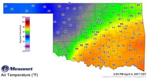
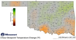
The evolution through the early afternoon appears largely on track with model forecasts leading up to the event with the small exception that the surface low appears to be ever so slightly south of where it was forecast. The warm front also is a bit south of where it had been placed before. The only thing this might do is shift the storm track a nudge to the south, but otherwise I suspect we will start to see CU develop and deepen along or just south of the I-44 corridor across OK. Initiation will probably occur by 3-4 PM. The real question is which location wins the meso-gamma-scale forcing lottery (i.e, where along the front do storms actually form), and will moisture be sufficient by that time for a serious tornado threat? Large scale moisture return has essentially been absent, but Oklahoma Mesonet obs have been confirming localized moisture pooling along the front and near the low throughout the day so far - multiple mesonet sites have stuck their noses up into the upper 50s for dewpoints. Those values are being sustained for the time being, but I'm not sure how much mixing will reduce those later on. RAP soundings are consistent with current SPC mesoanalyses which also confirm OK mesonet obs, but it looks like CAPE is only going to max out in the 1000-1500 range, with the upper end of that range being optimistic.

More due to work issues than anything else, I am about 90% on not heading out. If there was more moisture and it didn't look like one dominant storm in NE OK was going to be flirting with being elevated, I would be more likely to head out.
 
I agree with Jeff's observation about the most intense storms possibly being elevated today. There's been a strong, consistent UH signal near the tri-state (OK/KS/MO) region on the CAMs. However, those same CAMs also consistently place that activity north of a tight baroclinic zone in relatively chilly air, with SBCAPE at or near zero. I certainly wouldn't rule out the possibility of tornadoes along the frontal zone today, but if they do occur, I think chances are good that they'll be grungy and relatively brief.
 
The locally higher dewpoints pooling between Stroud and Tulsa on 44 with a bit less isentropic soup just to its north along the cool side of the front definitely seems to be a decent bet for a target if any storm manages to stay rooted south of the WF. Similar to what Jeff noted, dewpoints have been flirting with the upper-50s for awhile and that region actually appears to be staying relatively steady even with further clearing up that way. The surface temps holding in the mid-70s this late is also encouraging to prevent that good moisture from cratering out.

1e2a3168aee3dae821b27145e59dc2c6.jpg

ab41cf6bce962031eda5591f9155ec73.jpg
 
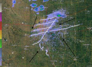
Pretty cool that this setup is materializing very near KTLX such that surface boundaries and other low-level features are pretty clearly visible. I don't think the WSW-ENE oriented bands are HCRs given that area hasn't been seeing much insolation, but there are wavy cloud streets on visible satellite oriented perpendicular to these, but displaced to the northeast. I'd say they're wave clouds associated with stable, but forced isentropic ascent over the warm front. Perhaps a double warm front can be seen, one just north of I-40, the other marked by the eastern terminus of the stable fine lines. Then you can see hints of a poorly organized dryline to the south of Norman, and the cold front taking shape south of I-44 southwest of OKC.

C_OK_anal_20Z.jpg
 
Back
Top