2017-03-23 EVENT (KS/NE/CO/TX)

Joined
Aug 9, 2012
Messages
585
Location
Macomb, IL
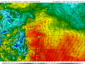
I haven't seen anyone start an event thread on tomorrow yet so I figured I might as well get the ball rolling, better late than never. The latest 18z 3km NAM ran (and the 12z) have me quite intrigued for the tri-state area of KS/CO/NE tomorrow evening if we can realize upper 50s dew points in this region ahead of the dry line/surface low that should be positioned in Northeast Colorado (~992mb).
8bf26763208266c50cc874f3a47eff71.png

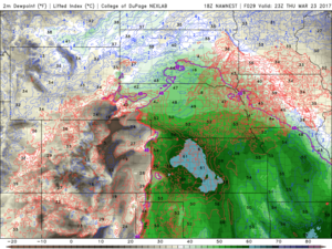
Ahead of this feature, the 3km NAM is showing a rapid and quite generous feed of moisture into the high plains region. It has a general regime of mid to upper 50's dew points however even a few low 60s being located in Northwest Kansas.
dc0e7273af82ce65536fe8dd7cd9cc35.png

Whether this is realistic or not, is the question. I think moisture will be the factor that keeps this event from either being a few hailers or a couple tornadic supercells that fire up.
50fcfc64848a36eaada030f7849e4748.png

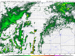
Obviously with it showing these moisture values on the high plains, instability values are quite generous as well with values of in excess of 1500 J/KG showing up as well. This all gets set into motion when an 70-80 knot H5 jet pushes onto the high plains tomorrow evening around 00z, firing storms along the dry-line/surface low region. If I was chasing, which I haven't decided if I'm going to, I would probably target the area around Burlington, CO right off I-70. That way I could drop south for the stuff that may form in Southeast Colorado and track into Western Kansas or move north and grab the stuff that fires along the surface low.

Overall my main concerns for this event will be moisture and I have some reservations about backing-aloft that I've seen on the soundings, which could do some things for storm mode, however moisture is my number 1 concern at the moment.
 
Deciding on whether I want to go down the dryline for possibly more isolated storms near the Lubbock area, or go into West central KS closer to the low with more backed winds. I think if the Td's in KS are in the mid 50's, we have a decent chance of seeing a tornado there. I'm just concerned about more cloud cover and cooler temps further north. I'm more of a dryline chaser anyway, so chances are that I will head W/SW of Lubbock unless something really gets my attention up north.
 
As Ethan has already mentioned moisture is a concern for tomorrow. Both GFS and NAM indicate moisture being mixed throughout the day. Kansas seems to retain a bit more pooling ahead of the dryline. Overall just not real impressed with the set up. The shear is fantastic I must say. Based on current trends I would probably target somewhere around Leoti to Wallace, KS area where the 500 jet favorably enters that area, doable moisture ( if realized ) and great backed flow. Not going to be chasing tomorrow. Doing some upgrades to the van before what could be a great day on Sunday :)
 
Risk vs. reward tomorrow. How far is one willing to drive for a pre-season gamble.

Northern target (NW Kansas and adjacent Nebraska) seems solid kinematically, but there are questions about moisture return with northward extent and storm mode.

Central target is a broad area from far eastern Colorado into western Kansas. Moisture should be good east and terrain/upslope flow could compensate farther west early in storm life cycles, but a glaring issue remains with storm coverage. One scenario would feature a really photogenic, lone supercell, but that's kind of conditional. We may see a relative min here in convection between the southern and northern targets.

Southern target seems like a good bet for convection just ahead of the dryline from West Texas into the panhandle. The main issues are limited moisture and a quick-to-linear storm mode expected. Shear is still more than adequate, but the T/Td depressions and LCL heights are problematic.

I'll be waiting until morning to make a decision, but each target has pros and cons. I'd lean toward a more local chase unless CAMs increase confidence with something solid farther north.
 
I am up way too early looking at models and forecasts for today. Especially since I am not that far from any target I would choose. Depending on which model you are choosing for your poison it could be a late night before you see anything. There are some capping concerns. And of course timing. I've been a fan of the 3KM NAM for the last couple years and with this event it does have storms firing before dark. HRRR model runs are just starting to come in and has things firing a little further east than the 3KM. The biggest kick in the ass with all of this for us Colorado chasers is if we are making this a one day trip, like I am, we get to drive back in a blizzard! A famous quote about this......."AWESOME"- Said no one EVER. In the end I am thinking I am going to head to Goodland and adjust from there.
 
It you take the HRRR at face value then the triple point should have a beast today. Several HRRR runs (8z to 12z) show a lone supercell up in NE. 3km NAM keeps the warm front closer to the NE/KS border.

Not chasing but I hope someone bites on the HRRR. I'd love to see pictures in a report thread.

Also, TX panhandle might see a discrete cell. Nevertheless, looks to be a late show with storms waiting till 00z-01z to really get going.
 
Original NAM runs kept wanting to paint a *possible CC* event further north...obviously models don't agree. But as we all know, this time of year it doesn't take a 65*dew to get things done -especially up west. However, moisture return is tough and I suspect even 0z and 06 runs may be overdoing moisture a little bit. H7 and even H85 temps looks just plain stupid for this time of year (2000m LCL are you kidding me!?!?) I am worried that the wave time and ascent certainly may limit convection along the dryline further south until near and after dark (when the CAP is weakening) Here is it almost 8 am and I still haven't decided what I'm doing yet - if anything. Have to admit though, that 0z through 03z looks interesting in far northwest KS/CO/NE to me. Winds back and LL jet increasing along with the true dump of the ascent.....Guessing game at this point. *if* I were going to chase, I suspect might play the northern end due to the ascent timing and what appears to be a slight dyrline bulge. But Who knows...its a slight risk at best so maybe some of us will get lucky.....Good luck to those that head out!
 
I have to agree with Lanny. I am liking northwest Kansas at the moment for the best shot at a tornado. I haven't had a ton of time to look at the models but from what I have looked at the northern play looks enticing. These early spring systems are always going to struggle with moisture quality so I don't get caught up in too much hype for these. I could see a small window for a quick tornado or two but more than anything am glad to see some much needed moisture chances. My bet for southwest Kansas would be that it gets a few degrees warmer than it is forecasted as well.


http://www.pivotalweather.com/model...&fh=12&r=us_c&lat=39.9169&lon=-99.6680&metar=
 
Just based off recent trends with the convective allowing models (HRRR, NAM3K, WRF) it looks like there may be an isolated shot at a cell somewhere on the I-27 corridor shortly before 00Z. Obviously western Kansas appears to be the better target for tornado chances, but moisture cratering on the Llano appears to have been somewhat staved off by persistent low-level clouds this morning meaning temps are still sitting in the upper-60s. This morning's AMA sounding was also encouraging with a pretty pronounced EML (although, the lower sfc temperatures may mean it becomes harder to break the cap than forecasted). Wherever that dry air is in the Hill Country/Edwards Plateau in 3-4 hours seems to be the key in whether or not the Panhandle target sees a beefy supercell or the more likely anemic, high-based stuff.
 
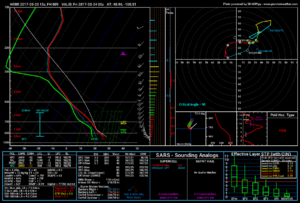
I decided to sit today out because of distance and moisture/capping concerns....it was a 11 hour drive and I had to make the decision last night, so I decided to sit out. Anyway, my forecast from the original post stands, I would be sitting in Southwest/Western Nebraska today, probably somewhere around North Platte. Some of the later HRRR runs have been showing an isolated cell or two going up in this area. Pulling up a forecast sounding ahead of this off the HRRR, it looks pretty favorable on paper. However I think we will be battling darkness here and how soon the boundary layer decouples and we are left with just an elevated hailer. Here is a sounding around 00z in Western Nebraska....not too shabby:

1435502722f8a83c02cca8308a635aeb.png

Later runs though, have been more lackluster on the convective development in this area until after sunset, so we shall see.
 
Moisture trends are encouraging for the northern target as near 60F dew-points are likely to pool in southern Nebraska by 00z based on 17z obs and recent HRRR progs. Given the time of year, it's kind of intriguing to have a severe threat this far north.
 
Has there ever been an isolated dry t-storm outlook within a slight risk before? There was also a fire warning in Ochiltree County with storms 40-50 miles to the west. That little line of storms in the TX Panhandle went right over that fire.
 
Back
Top