Quincy Vagell
EF4
March is about to storm in like a lion?
The global and convection allowing models have been consistent with showing a broad warm sector developing later today with strong winds aloft to create an overlay of moderate/strong instability and favorable wind shear for supercell thunderstorms. The parameter space suggests that some significant severe weather will be possible, of all hazard types, including significant wind gusts, very large hail and strong tornadoes.
The details have been somewhat unclear with respect to when and where storms may initiate, how numerous they will be and if the threat will hold steady or even ramp up overnight Tuesday into early Wednesday.
Overview:
An upper level trough, fairly progressive, will pivot across the Plains Tuesday into Tuesday night. Ahead of the trough, seasonably strong mid and upper level winds will nose into the Mississippi Valley and Midwest late Tuesday. Relatively steep mid-level lapse rates will overspread the Mississippi Valley and Midwest with cooling temperatures aloft. Moisture transport will be aided by an increasing low-level jet, pushing dew-points well into the 60s across Arkansas, with 60+ dew-points as far north as central, if not northern Illinois shortly after peak heating. The result will be a seasonably broad warm sector. At least isolated thunderstorms are expected to form by late afternoon and early evening across portions of AR/MO/IL.
Mesoscale details:
Forcing for ascent will be relatively modest during peak heating, but height falls will become more substantial by Tuesday evening. At the same time, an increasing low-level jet should result in 50kt winds at 850mb by 00z over MO/IL, only increasing in speed and aerial coverage overnight.
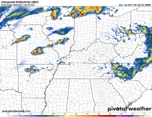
1. An area of low pressure should eject toward the IA/IL border region, highlighting one focus area for potential robust thunderstorm development. In this area, a pseudo dryline bulge-type feature has been modeled by both the 4km NAM and HRRR, creating an effective wedge of instability/moisture pooling across west-central to central/northern Illinois. While models have been somewhat inconsistent with convective initiation here, this region will be on the nose of the low-level jet and when coupled with moderate instability, favoring warm air advection-type convection. Large to very large hail would be the most apparent threat. If the storms fire near or north of the better quality low-level moisture, they may be more elevated in nature. However, if a cell or cells were to fire within the narrow warm sector, on the southern fringe of the initial activity, a tornado threat, possibly significant, could also develop. The latest HRRR shows elevated storms giving way to discrete surface-based storms by early evening in northern IL.
2. Further south, across MO/AR, models were initially hesitant and inconsistent with convective initiation, but now the multi-model consensus shows discrete or at least semi-discrete convection developing by 00z across the southern half of MO into the northern half of AR. This area is progged to heat rather effectively during Tuesday afternoon, as the 4km NAM and HRRR develop upwards of 2,000 J/kg MLCAPE by 00z. The most likely scenario would feature one or two broken bands of convection, perhaps one across southern MO and another over northern/central AR. Given the instability in place and substantial wind shear, these storms that will most likely be surface based and pose the threat to rapidly become intense. Very large hail and tornadoes, potentially strong, would be the initial hazards. Given the directional shear into the overnight hours and an increasing low-level jet (55-60kts over a broad area), it is conceivable that at least semi-discrete storms may continue northeastward into early Wednesday, eventually reaching southern IL, southern IN and perhaps western KY. This is supported by the 06z 4km NAM and the 00z Euro suggests a similar scenario given its modeled precip fields.
3. To the west, an extensive squall line may develop just ahead of a cold front, affecting MO/IL Tuesday night and eventually points east early Wednesday. Damaging winds, perhaps some significant wind damage swaths, should be the predominant threat here. A few tornadoes and some hail may accompany such a squall line as well, but it will be the lead cells to the east that should post the greatest tornado threat.
While the parameter space is impressive for late February and highlights the potential for significant severe weather, the coverage of robust storms is still a big question mark. The threat area is rather broad, and it is plausible that only a couple of intense storms develop. I think this is the main reason why SPC has not issued a moderate risk at this time. If a large number of storms develop, the storm mode could get messy, leading toward storm mergers and a severe threat that peaks during the evening. Given the trends and forecast model solutions, I think it is most likely that storms are sparse/isolated, as opposed to widespread. This is a good thing for those hoping for significant severe storms, but not good for large population areas that may be in the way of such storms.
Chasers can pick one of multiple targets. Central/northern Illinois seems like the best bet for one hoping to play it safe, with a good road network and favorable terrain. The chase area becomes less favorable to the south, especially from southern Missouri into northern Arkansas. There is a play in the Arkansas valley region, but that is a relatively narrow area and the window for chasing here could be fairly small. If storms initiate and/or persist far enough east, the terrain and road networks get much better into the Missouri bootheel and northeastern Arkansas.
Below is the 07z HRRR forecast simulated radar at 01z Wednesday, which highlights the threat areas mentioned above and is one possible solution given the expected setup:

