Quincy Vagell
EF4
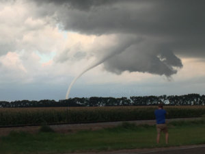
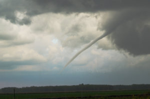
It was a very interesting day that started with a rogue tornado in Iowa. The main show was a late one, with the first tornado I witnessed in Minnesota beginning at 8:00 p.m. over Beltrami. It was a relatively narrow tornado that lasted for about five minutes. Does anyone who made a cameo in the first photo?
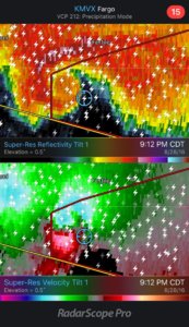
The storm structure on both radar and in person was very messy, as if a clump of storms were all fighting for life. The cluster got its act together with time and an elongated wall cloud formed. Suddenly, shortly after 9 p.m., rotation consolidated/tightened and a large, wedge tornado formed. From my vantage point, it only lasted a minute or two, before transitioning into a multi-vortex tornado that went on to spin off an unknown number of brief tornadoes for the next hour or so. I didn't get any photos due to poor lighting, power lines and safety concerns, but I did make a brief (low quality) Periscope broadcast.
Taking a step back, the structure of the storm was expansive and well-defined with layers/striations. It was one of the longest, most pronounced light shows I can remember. The whole setup reminded me of Coleridge, with the major caveat being that this storm was considerably more tame in comparison. Still the evolution, starting with the storm forming shortly before sunset ("late" start), moving slowly southeast/nearly stalling, and spinning off several tornadoes, was quite similar.


The storm structure on both radar and in person was very messy, as if a clump of storms were all fighting for life. The cluster got its act together with time and an elongated wall cloud formed. Suddenly, shortly after 9 p.m., rotation consolidated/tightened and a large, wedge tornado formed. From my vantage point, it only lasted a minute or two, before transitioning into a multi-vortex tornado that went on to spin off an unknown number of brief tornadoes for the next hour or so. I didn't get any photos due to poor lighting, power lines and safety concerns, but I did make a brief (low quality) Periscope broadcast.

Taking a step back, the structure of the storm was expansive and well-defined with layers/striations. It was one of the longest, most pronounced light shows I can remember. The whole setup reminded me of Coleridge, with the major caveat being that this storm was considerably more tame in comparison. Still the evolution, starting with the storm forming shortly before sunset ("late" start), moving slowly southeast/nearly stalling, and spinning off several tornadoes, was quite similar.
