Quincy Vagell
EF4
I picked northwestern South Dakota as my target today and after the afternoon got off to a slow start (a cell in NW SD flared up and dissipated and cells to the south merged together), one supercell (on the edge of two radars) in southeastern Montana really got its act together.
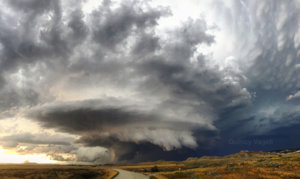
Brandon Copic reported 4-inch diameter hail with this storm, but I stayed on the southeast side, capturing structure and plenty of photos. The initial supercell crossed into South Dakota near Camp Crook and was clearly rotating with scud and a fairly low base. It put on a show with mammatus around too, but I did not see any tornado. I'm not even sure I saw any conclusive funnel, but early on view was obstructed by hills and there were some low-hanging appendages.

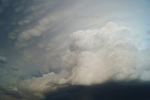
As the first supercell was taming down a bit, a new updraft went up on the southern flank, nearly directly over me. Below is a photo of that updraft developing and pairing nicely with some mammatus.

I followed the cluster of storms back east for quite a while and as light gave way to night, there was a constant lightning show to watch. To get an idea of how my chase looked, I condensed roughly an hour of video into under four minutes:
Brandon Copic reported 4-inch diameter hail with this storm, but I stayed on the southeast side, capturing structure and plenty of photos. The initial supercell crossed into South Dakota near Camp Crook and was clearly rotating with scud and a fairly low base. It put on a show with mammatus around too, but I did not see any tornado. I'm not even sure I saw any conclusive funnel, but early on view was obstructed by hills and there were some low-hanging appendages.

As the first supercell was taming down a bit, a new updraft went up on the southern flank, nearly directly over me. Below is a photo of that updraft developing and pairing nicely with some mammatus.

I followed the cluster of storms back east for quite a while and as light gave way to night, there was a constant lightning show to watch. To get an idea of how my chase looked, I condensed roughly an hour of video into under four minutes:
