Quincy Vagell
EF4
Most of the visible tornado reports came out of Illinois with this event, but the states outlined in the title appeared to see the most significant severe, overall.
I started the day in eastern Iowa and was pretty certain that storms would not mature until Illinois, so I headed east. The first dominant supercell popped up right near the IA/IL state line and I stayed with it for a while, but aside from displaying a quasi-wall cloud at times, it never produced. I eventually saw a new cell pop up to the south and I blasted in that direction.
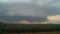
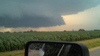
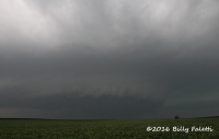
The storm had a hook-like appendage on radar, but didn't look all that impressive from my vantage point. I stuck with the storm and when it became tornado-warned, I was initially surprised, since it looked junky, at least visually. Some time later, the storm quickly organized and showed considerable low-level rotation. The picture from below was taken three miles west of New Bedford, as the cloud base was lowering and the storm looked like it might be trying to produce.

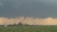
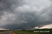
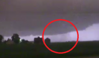
I witnessed a funnel cloud with the storm for a couple of minutes, one mile south of Manlius, IL. From other reports, it is possible that this was a tornado, but that was not clear from where I was watching it.

I followed the storm southeast, but suddenly my chase day was cut short when a huge deer appeared on the road and my front end was smashed. This was all while it was windy and rainy, but luckily I was going only about 45-50 mph and glanced it, so I was not injured and my car is still somewhat driveable.
Not a bad chase for me, considering up until almost 8:00 everything was fairly messy looking on both radar and in person. Even if it wasn't for the deer, it's unlikely that I would have seen anything impressive in the lingering time before darkness crept in.
I started the day in eastern Iowa and was pretty certain that storms would not mature until Illinois, so I headed east. The first dominant supercell popped up right near the IA/IL state line and I stayed with it for a while, but aside from displaying a quasi-wall cloud at times, it never produced. I eventually saw a new cell pop up to the south and I blasted in that direction.
The storm had a hook-like appendage on radar, but didn't look all that impressive from my vantage point. I stuck with the storm and when it became tornado-warned, I was initially surprised, since it looked junky, at least visually. Some time later, the storm quickly organized and showed considerable low-level rotation. The picture from below was taken three miles west of New Bedford, as the cloud base was lowering and the storm looked like it might be trying to produce.
I witnessed a funnel cloud with the storm for a couple of minutes, one mile south of Manlius, IL. From other reports, it is possible that this was a tornado, but that was not clear from where I was watching it.
I followed the storm southeast, but suddenly my chase day was cut short when a huge deer appeared on the road and my front end was smashed. This was all while it was windy and rainy, but luckily I was going only about 45-50 mph and glanced it, so I was not injured and my car is still somewhat driveable.
Not a bad chase for me, considering up until almost 8:00 everything was fairly messy looking on both radar and in person. Even if it wasn't for the deer, it's unlikely that I would have seen anything impressive in the lingering time before darkness crept in.


.jpg")
.jpg")
.jpg")
.jpg")
.jpg")
.jpg")
.jpg")


")