Good day all,
Like many others who targeted SW Kansas this day, I was on the multiple tornadoes this day as well. Although posting on this late, here is my logs for May 24, 2016...
1). May 24, 6:30 PM - Interception and observation of an extremely severe and tornadic thunderstorm from north of Mineola, Kansas to and past Dodge City in Clark and Ford Counties from along Highway 283. This thunderstorm was a violent cyclic classic supercell producing multiple tornado "families". The storm developed to the northwest of Mineola and moved to the northeast, barely missing the western portions of Dodge City. The core of the storm, containing extremely large hail (one report had 5 inch hail, larger than a compact disc) and strong winds, was not penetrated. The storm produced at least 8 tornadoes with multiple cycles, and was observed from initiation to dissipation south of Jetmore, Kansas. The tornadoes were pretty much all varieties: stove pipe, elephant trunk, multiple vortices, cones, even a truncated wedge! Even more spectacularly, there were times when there were two (twins), or even three, tornadoes on the ground simultaneously (usually one from the original mesocyclone still on going, with a new tornado on the next new cycle)! The tornadoes remained mostly over open fields, and thankfully passed west of Dodge City, damaging mostly outbuildings. The supercell storm had an impressive and striking visual appearance (like an "upside down wedding cake" and striations). One of the last tornadoes onserved was even anticyclonic (revealed with time-lapse footage)! Frequent lightning with some close hits was also encountered, with isolated 1" hail stones falling in 50 to 60 MPH inflow. Conditions causing the storms were surface heating, a low pressure trough, dryline / boundary interactions, and upper trough. A 2009 Ford Escape SUV was used to chase the storms. Documentation was digital stills and HD video. A tornado watch was in effect for the area until 12 AM CDT the next day.
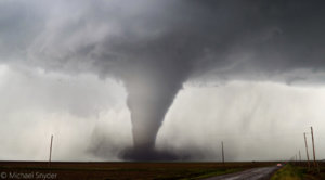
 Above:
 First tornado touches down during the afternoon / evening south of Dodge City, Kansas on May 24. This storm will be referred to as the "Dodge City Supercell", a classic and violent cyclic storm that will produce at least 8 tornadoes, some of which with multiple instances on the ground simultaneously!
 Above:
 First tornado occludes, then begins to rope out slowly. This view is zoomed in to show the intense ground circulation and two chase vehicles in close proximity.
 Above:
 With the near steady-state stove pipe tornado in progress, the new mesocyclone forms sympathetically east of the main one. This new area goes on to produce a multivortex tornado, along with a few smaller tornadoes, all while the stove pipe to its left is on-going!
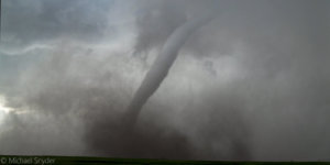
 Above:
 View of the main and most intense cyclic tornado of this storm. A large stove pipe quickly develops over the open country south of Dodge City (May 23).
 Above:
 Both the old (left, with massive stove pipe tornado) and new (right, with tornado on the ground as well) mesocyclones. Twin, or even three, tornadoes (wow)!
 Above:
 View a later showing a large truncated cone / wedge with a stove pipe (internal subvortex) in the middle of it! Note that another mesocyclone is about to form east (right) of this tornado, and will be part of the next storm "cycle".
 Above:
 Twins again! Rope tornado from former mesocyclone still on the ground, and a large elephant trunk / stovepipe tornado on the newest mesocyclone to the right. The view is NW and the storm is north of Dodge City and south of Jetmore.
2). May 24, 10:00 PM - Penetration of a severe thunderstorm near Pratt, Kansas in Pratt County along Highway 54 / 400. This storm was a multicell severe / HP supercell storm. Very heavy rains, frequent lightning with close hits, hail up to half-dollar (1.5"), and winds gusting over 60 MPH. Conditions causing the storms were a low pressure trough, boundary interactions, and upper trough. A 2009 Ford Escape SUV was used to chase the storms. Documentation was audio. A tornado watch was in effect for the area until 12 AM CDT the next day.


")

 Nice pic James. I just dug through my pics again and found this one with three tornados in it. It's not as good as yours, but I'm happy because I could zoom in and see all three.
 Since I've been editing with lightroom, photos are coming out better. Here is some more eye candy.
.jpg")