Tom Dulong
EF2
Thought I would start a thread, since I am not chasing today but plan to get out with the 10,000 other chasers tomorrow.
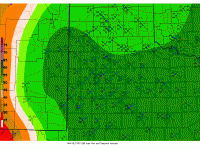
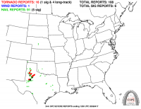
Here is the analog NAM forecast [http://www.eas.slu.edu/CIPS/ANALOG/DFHR.php?reg=SP&fhr=F036&rundt=2016041512] from the past (20090417/0000) that is the second-best match to what the 12Z NAM advertises for tomorrow evening [first image] and the actual severe weather reports for that day [second image]. I chose to not use the best analog, since the only tornado reports were from north central OK (does not make sense based on latest model forecasts). In the 20090417/0000 event, the surface dews ahead of the dry line were only in the mid 50s 12 hours prior but rose to lower 60s by storm initiation. Based on this, I would think there would be at least a 5 percent risk for tornadoes drawn in the SWO Day 1 for tomorrow.
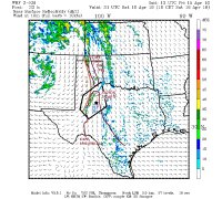
I often use the Texas Tech 3-km WRF model. Here is what it shows for 21Z tomorrow (I have annotated its forecasts of various other parameters. My initial target would be somewhere east of LBB (Guthrie) by around 18Z. Initiation is forecast for 19Z-20Z.

Here is the analog NAM forecast [http://www.eas.slu.edu/CIPS/ANALOG/DFHR.php?reg=SP&fhr=F036&rundt=2016041512] from the past (20090417/0000) that is the second-best match to what the 12Z NAM advertises for tomorrow evening [first image] and the actual severe weather reports for that day [second image]. I chose to not use the best analog, since the only tornado reports were from north central OK (does not make sense based on latest model forecasts). In the 20090417/0000 event, the surface dews ahead of the dry line were only in the mid 50s 12 hours prior but rose to lower 60s by storm initiation. Based on this, I would think there would be at least a 5 percent risk for tornadoes drawn in the SWO Day 1 for tomorrow.

I often use the Texas Tech 3-km WRF model. Here is what it shows for 21Z tomorrow (I have annotated its forecasts of various other parameters. My initial target would be somewhere east of LBB (Guthrie) by around 18Z. Initiation is forecast for 19Z-20Z.
