• A friendly and periodic reminder of the rules we use for fostering high SNR and quality conversation and interaction at Stormtrack: Forum rules

    P.S. - Nothing specific happened to prompt this message! No one is in trouble, there are no flame wars in effect, nor any inappropriate conversation ongoing. This is being posted sitewide as a casual refresher.

2016-04-15 REPORTS: TX/OK/KS

Greg R

EF0
My target area was initially in SE Colorado, but took a chance and headed down to the Texas Panhandle. I was kicking myself for leaving Colorado as I heard reports of the tornado near Lamar. Thankfully, though, I had a few cells to work with in Texas. After 3:00pm there three cells NW of Amarillo... the original thought was to hit the northernmost cell but it started to weaken just as the middle cell started strengthening. I followed that cell from Dalhart (where there was significant rotation and when it first became tornado warned) onto Kerrick and eventually to just south of Elkhart, KS where it produced after 8p.

Every time I was in a good position it didn't happen but thankfully others did get a good view (and snapped better pics than what I've got below)! Hopefully no one was injured. But know I can't say the same for a few power poles near the junction of Rte 412 and Hwy 95 – some of them just didn't make it!

Tornado_April15_2016.jpg
 
I went west and was on the other side when I got the first tornado warning notification. I stayed out west and tracked a storm that came out of New Mexico. I had called it a day when I got notified about tornado near Eva. I then got call to go on stand by but since I was where I was, it wasn't possible. I did get informed that there was a lot of damage north of Four Corners, but nothing specific other than power poles. When I came back this way there was one huge pole on 412 just west of Four Corners that got hit. It was leaning but still hanging on. Crews were en route to fix it. There was also a large fire northwest of Guymon, but at this point I don't know what caused it.


Sent from my iPad using Stormtrack mobile app
 
I had a great day in the TX/OK panhandles. Started out near Dalhart and followed the lone supercell into the Oklahoma panhandle. There was some great structure along the way as we cruised northeast on HWY 54. Almost gave up on the storm while crossing into Oklahoma because I thought the T/TDs were just too cold. Made it up to HWY 412 near Eva, OK and wanted to ease west just to sample some hail. From there noticed the wall cloud - 2 brief tornadoes formed followed by the larger rain wrapped tornado that crossed 412. Called it a day after that.Screen Shot 2016-04-15 at 8.16.32 PM.pngScreen Shot 2016-04-15 at 8.17.36 PM.pngScreen Shot 2016-04-15 at 8.19.32 PM.pngScreen Shot 2016-04-15 at 8.19.42 PM.pngScreen Shot 2016-04-15 at 8.17.36 PM.png Screen Shot 2016-04-15 at 8.19.32 PM.pngScreen Shot 2016-04-15 at 8.19.42 PM.png
 
My target was Lamar, Colorado yesterday. While traveling south on Highway 287 I had been watching a developing cell near Eads, Colorado that was the only player in town. Visually it looked better and better on approach and velocity quickly increased. I was able to catch the full life cycle of this very photogenic tornado which touched down just south of Eads.
Forum1.jpg
Forum2.jpg

To the east of the main circulation a 50-75 yard wide debris cloud formed under rapid rotation and appeared to be a second tornado. The condensation funnel never formed but the debris cloud lasted for 3-5 minutes.
Forum3.jpg

Incredible rope out
Forum4.jpg

The storm was moving NE and crossed over Highway 287 just east of Eads. It put down a second debris cloud, possibly tornado #3, under a small funnel which quickly became hail/rain wrapped.
Forum5.jpg

After a lull in intensity along the dry line, around 18:12 velocity was looking good as was the base. A brief tornado touched down northwest of Wiley, Colorado and signaled the end of tornadic development and the beginning of heavy rain.
Forum6.jpg
 
Started out near Dalhart and followed the lone supercell into the Oklahoma panhandle. There was some great structure along the way as we cruised northeast on HWY 54. Almost gave up on the storm while crossing into Oklahoma because I thought the T/TDs were just too cold. Made it up to HWY 412 near Eva, OK and wanted to ease west just to sample some hail. From there noticed the wall cloud - 2 brief tornadoes formed followed by the larger rain wrapped tornado that crossed 412. Called it a day after that.

I had a very similar experience. Meteorologically this event was not super impressive, but I'm very happy with how I played it logistically.

My initial plan was to get to Amarillo by early afternoon. I figured once there I would fine tune and figure out a more focused target. After waffling around the west side of town for awhile, I decided to head towards new convection developing on the TX/NM border to the northwest. Cut up to Channing on Ranch Road 1061 and then meandered around Channing for awhile waiting for something to become dominant. After seeing a very shallow lowering appear under the otherwise featureless and high base of the storm just crossing Channing's latitude, I pursued it north through Hartley and eventually towards Dalhart. Wound around on County Roads up to FMs 807 and 281. Noticed a rotating wall cloud had formed back to my WSW, so went back west to put myself in its path. It looked like the RFD blew it apart, which was disappointing since the rotation and vertical motion looked promising up to that point.

This storm seemed to struggle mightily with barely adequate moisture content in the low levels. It looked pretty good aloft, but the cloud base was so high most of the day. By the time I got up to US 54 and headed northeast up to and through Stratford, I figured the day was about over other than some structure. So I sped well northeast to try to fit it in my lens. I probably could've used another few miles, but the structure at this point was just tremendous regardless:

160415_046-1.jpg

By the time I was approaching the Oklahoma panhandle, I figured I would just continue on through Texhoma into Guymon and begin the long drive home. I stopped briefly on the north side of Texhoma and watched a strange evolution as the original updraft seemed to die off and get replaced by a flanking updraft to its west, thus discretely propagating the storm more north than anything. I caught what appeared to be a lowering struggling in the dry air 20 miles to the west. I decided I would go as far north as US 412, wait for it to pass north, and then start home (assuming it wasn't going to do anything more because it hadn't given me much reason to think it would).

When I got to 412 I started getting small hail. I saw there were still some 60+ dBZ returns in the core, so combined with a scuddy lowering I figured, "I'm already out here...what's another 10 miles?" and went west to sample hail. After several miles the hail had stopped, but there was a suspicious scuddy lowering below the base still. Before I had time to do much, a skinny condensation finger started dropping, and rotation visibly increased. I witnessed the first tornado from the northeast:

160415_059-1.jpg

The tornado quickly dissipated, but still seeing rotation in the cloud base and recognizing my relative position to it, I decided to zoom further west for a close intercept should it touch down again. Just after I cleared the north side of the wall cloud and got northwest of it, my risk was rewarded:

160415_068-1.jpg
160415_073-1-2.jpg

The best part about this sequence was there was no one else around in eyesight while this second tornado proceeded. I only saw 3 other vehicles over about a 10 minute stretch around this time, and only one was a chaser. I thought that was very unique considering the numbers I had seen earlier in the day. It's also pretty much unheard of in Oklahoma anymore. These two tornadoes were also my first in the panhandle.

I crept slowly back to the east to keep pace just behind the west edge of the bear's cage. I had front row seats to the sudden core dump that occurred right in the middle of the wall cloud. While moderate rotation continued under the wall cloud, no obvious tornadoes appeared to occur. I saw very faint wisps along the ground once or twice, but it appeared the storm was still struggling to birth a full blown monster given the low-level shear at the time. I can only imagine how spectacular a show may have occurred had mid-50s dews made it into the Oklahoma panhandle.

Anyway, I skirted the circulation that evolved as it crossed 412. The circulation became extremely high-contrast rain-wrapped. The transition from zero-visibility precip to clear air was amazingly tight. I could see individual wisps or sheets of precip orbit around the south side of it. Standing water on the road made it very easy to witness the wind direction turn from northwest to westerly to southwesterly to southerly in a span of no more than a mile. I passed a single power pole that had been bent at about a 45 degree angle, which supports the notion that this circulation was only very weakly tornadic if at all (it could've just been an inflow jet or something that did that). I pursued it north on OK-95 a few miles before turning around as I did not feel safe penetrating the liquid circulation in increasing darkness. Considering how long of a drive back home I had, how dark it was getting, and the rush from what I had just witnessed, I was content dropping the storm even if it did go on to produce other tornadoes.

I did capture a fair amount of video from the chase. Unfortunately my camera defaults to autofocus every time I turn it off or take out the battery, and I didn't think to switch it back to infinity before recording, so much of my video is plagued by the classic focus-on-the-raindrops-on-the-windshield issue. I also forgot to record the sequence where I passed around the rainy circulation. Oh well. It's only mid-April.
 
Last edited:
Started in KC at 4am, drove towards Pampa,TX as my original target. Hopped on the cell between Dalhart and Hartly where I caught the first brief funnel. After that it was just following and shooting structure when I had a chance.
The dirty inflow was pretty constant. Every bit of gear I have is coated with a layer of grime. I headed back to KC after dark. I captured a few keepers.
DSC01035.jpg DSC01155.jpg IMG_5850.jpg Untitled1.gif
 
Basic summary of storm:

April 15, 8:00 PM -
Interception and observation of an extremely severe and tornadic thunderstorm that paralleled Highway 54 and to its northwest from near Dalhart, Texas in Dallam and Hartley Counties and points northeastward as far as Hough, Oklahoma in Texas County. The storm was a cyclic classic to HP supercell storm. The core of the storm was not penetrated directly. At least 3 tornadoes were observed with this storm near Eva, Oklahoma in Texas County around 8 PM, CDT from along Highway 412. The first tornado was an elephant trunk, which lasted a few minutes. The second, forming just N of the first was a large stove-pipe tornado lasting about 5 minutes. The third west of the first two (that formed on the forward flank of the mesocyclone), was farther west and became a wedge tornado. This tornado quickly became rain wrapped and view of it was lost as the storm continued to the NE. Very heavy rains, hail to 1" (during indirectly penetrating the storm), lightning, and winds near 70 MPH were encountered as well. The storm inflow SE of the storm was at least 60 MPH, pulling dirt and dust off the ground near Stratford, and ingesting it into the storm main updraft prior to cyclic tornado genesis. The storm core had hail to baseball sized or larger. The storm had a striking visual appearance, with a "stacked plates" effect, inflow / beavers tail features, mammatus, and RFD clear slot. The storm remained over mainly rural areas, with damage being mainly to powerlines. The storm eventually continued NE after dark to the NW of Liberal, Kansas, before weakening and merging with a storm cluster. The storms were caused by a low pressure area, surface heating, strong upper level low, and advancing dryline. A 2016 Toyota Rav4 was used to chase the storms. Documentation was digital stills and HD video. A tornado watch was also valid for the area until 10 PM CDT.

Pictures:

1). View of supercell storm in Texas County (just before it started to produce tornadoes)...

Chase_Apr15_01.jpg

2). First tornado SE of Eva, OK.

Chase_Apr15_02.jpg

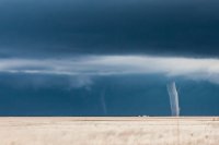
3). Second (with weaker twin to it's left) stove-pipe tornado SE of Eva, OK.

Chase_Apr15_05.jpg

4). Third wedge tornado behind the forward flank / in the main meso!

Chase_Apr15_04.jpg


Below is the detailed chase log:


This was a "spot" chase trip during the late week / weekend of April 14 through 17, 2016 with April 15 and 16 being the days available for chasing. After clearing my work schedule for Friday (April 15), the plan was to fly out to Denver, Colorado (late on April 14) and target the areas from SE Colorado into the Oklahoma and Texas Panhandles, and return to Chicago early on April 17. The anticipation of chasing these days started a week in advance, with a strong upper air low (after crossing the Northern Pacific ocean) forecasted to be over the western USA by Friday, April 15. Models progged this upper low to stall and weaken due to a blocking ridge eastward over the US Midwest and upper MS river valley. With a time constraint and pretty much April 15 being the "main" chase day, I opted to fly out and rent a vehicle instead of driving my own.

The initial plan was to leave Chicago late evening on 4/14. After getting a report my flight was delayed, I quickly changed for an earlier on-time flight and arrived into Denver during the evening of April 14. I picked up the rental vehicle, a 2016 Toyota Rav4 SUV, and spent the night near Aurora, CO east of Denver. With heavy snow forecasted later in the period, I opted for an upgrade to the SUV rental. I also changed my morning return flight on Sunday (April 17) to the afternoon to avoid any issues with the predicted heavy snow that was to affect Denver on April 16 through the morning of the 17th. Upon waking up early on April 15th, I forecasted and decided the right place to chase would be in an area from SE Colorado (around Springfield), southward into the Oklahoma Panhandle and as far as the area north of Amarillo, Texas.

I started out by heading east on I-70 to Limon, then southeast on Highway 287 / 40 through Kit Carson and eventually through Lamar and Springfield (having lunch there). Meanwhile, the Storm Prediction Center (SPC) had an area in a enhanced risk, with a 5% tornado, 15% wind, and 30% hatched hail in the outlook, which extended from SE Colorado and into Texas along an axis centered north of Amarillo and as far south as Lubbock. A developing dryline, and low pressure area in NE New Mexico were becoming apparent, with a dewpoint axis in the 50's. While heading south near Lamar on Highway 287, a cluster of highly sheared, agitated cumulus was noted to the west. This was not the primary target area, but this later formed into a tornadic thunderstorm that would produce the first tornado of the day near Eads, Colorado in upslope wind flow to the south of a slow moving cold front.

By mid to late afternoon, I entered Oklahoma via 287 / 385, through Boise City, and eventually the northern Texas Panhandle near Stratford. SPC issued mesoscale discussion 385, and subsequent tornado watch box 91 valid until 10PM CDT for my area. While mulling over the intense tornadic storm far to the north in SE Colorado, I noted convective initiation to my southwest just east of the TX / NM border. I headed southwest through Dalhart along 54 where I intercepted the cluster of strong and severe storms. One very intense cell intensified and became the main storm of the day. This supercell storm would track northeast back near Dalhart and continue northeast into Oklahoma and eventually produce tornadoes from near Eva, OK in Texas County and northeast of there at dusk. The storm remained NW of, and paralleled Highway 54, which made that route helpful.

Tornadoes were intercepted with this storm on Highway 412 near Eva, OK. I continued with the storm to near Hough, OK along Highway 136 and ended the chase after dark. I headed back down 136 to 54, spending the night back in Dalhart, Texas. Hail (up to 1") was also observed during an overnight severe storm in Dalhart. April 16 was another chase day, although not expected to be as active as the day before. The target area was pretty much near Amarillo and points east and southeast of there. A Pacific cold front and dry line interaction was involved with this days setup, and after forecasting it was apparent I did not have to travel very far. I left Dalhart via Highway 87 to Dumas, then south to Amarillo for lunch at the Big Texan steakhouse (a must for chasers in that area whether you catch tornadoes or not)!

A strong thunderstorm (due to an on-going line of strong and severe storms) passed over the restaurant and dropped marble sized hail. The SPC again had a similar outlook for this area, maybe shifted a bit east or southeast, with a tornado probability of 5%, and hail and wind probabilities both at 15%. Mesoscale discussion 395 and subsequent tornado watch box 93 valid until 9 PM CDT was also issue for this area, with the lower 2/3 of the watch area having the highest tornado threat. After lunch, I headed east on I-40 to highway 207, observing a rotating storm NW of White Deer. This storm weakened as outflow under-cut it, so I headed back to I-40 east, then to Mclean, and south on 273 to Hedley. The "tail-end Charley" supercell was intercepted from SE of Clarendon near Lelia Lake and acquired intense rotation (with a possible broad / brief tornado).

This storm was followed back north and northeast by back-tracking along highway 273 until it weakened NW of Shamrock. I ran into many storm chasers, including Randy Hicks while on 273. The chase was completed near Shamrock and back on I-40. I headed back west to 273, and NW through Pampa and Borger, picking up 152 West to meet highway 87 and eventually 287 / 385 north out of Dalhart and back across the Oklahoma Panhandle and into SE Colorado. I continued as far as Lamar, Colorado, by 11 PM for the night. As I arrived in Lamar, I was pulled over briefly for a mistaken U-Turn, but wound up having a great talk with the officer (no citation issue), who was amazed on my storm chasing endeavors! I got a drink at the local bar in Lamar, and stayed at the hotel on the north side of town. April 17 was pretty much a travel day back to Denver.

I headed back up 287 to 40 and eventually I-70 via Limon. Near Hugo, CO, the snow swath "gradient" was encountered. By Limon and into Denver on I-70, heavy blowing snow and wintry travel was encountered. This was the tail end of a major winter storm that dumped up to 3 (or even 4) FEET of snow in the Denver area. I progressed slowly on I-70 (roads were not that bad) back into Aurora. After having lunch, I headed to the airport, returned the rental vehicle, and flew back to Chicago (luckily my flight wasn't one of many cancelled). This was the end of this chase trip. Total mileage was around 1,120 miles.
 
Here's a few photos from my chase - man what an awesome day!
0415161426aPT.jpg
Looking SW from just south of 287, west of Eads.

0415161434a.jpg

0417161659a.jpg
2" hail collected from north of Eads.

0415161453a.jpg
A new circulation/wall cloud formed on the Eads supercell, which would produce another brief tornado ENE of Eads.

0415161803b.jpg
Updraft base SW of Wiley, which would produce a brief funnel (tornado?) minutes later. I stood around gawking at this scene a bit too long, so I didn't get a very clear look at it.

0415161825b.jpg
Rain-wrapped funnel seen from the east while driving N on 287 from Wiley. I couldn't confirm that it touched down, but Eric Hurst posted a much better photo of it, probably taken a few minutes before I took this one I'm guessing.
 
Everyone owes me a "thank you", as once I left the storm it finally did it's magic. I was pretty slow to commit to the Dalhart storm initially while waiting in Dumas. Just wanted to see which storm would take over. It was a fun chase while it lasted for me from Dalhart to just past Stratford, but as it neared the border a number of things lead me to start driving for the storm near Amarillo.

Just a few things I noticed (which led to me leaving the storm):
1. Shrinking base
2. Left turned (weakened rotation)
3. Dew points were about 5 degrees lower where the storm was headed (Liberal dew was 48)

Wish I had stuck with it, but it is typical of the luck I have while chasing. Also typical that I got enough structure to drive home content. (Content for me at least. I always miss tornadoes). I can say I wont make that mistake again, but that would be a lie.

Some shots near Stratford.

f9c25588b8c8ea7c1e438c351e9da6e1.jpg

e437977ddb3a5a7fab3259d78822f238.jpg

d0a66195bd7336098f678dc67f8881d2.jpg

7699fa54689b5bd1e1219045df96f1bf.jpg
 
Does anyone have information on the storm as it moved north from Eva, Oklahoma toward Elkhart, Kansas? The last report we received was around 8:21 PM about 6 miles north-northeast of Eva. On our storm survey we found damage to a power pole about 12 miles north of Eva on Highway 95. Did anyone witness a tornado around this location after approximately 8:20 PM? Thanks for the help.

Randy Bowers
Forecaster - NWS Amarillo


Timestamp 8:20:57 I'll review my GPS, but Im pretty certain I was well East of EVA aiming NW.
 

Attachments

  • IMG_6228.jpg
    IMG_6228.jpg
    427.1 KB · Views: 149
Back
Top