• While Stormtrack has discontinued its hosting of SpotterNetwork support on the forums, keep in mind that support for SpotterNetwork issues is available by emailing [email protected].

2016-04-15 EVENT: CO/KS/OK/NM/TX

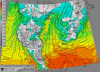
I've been trying to tell myself to not bite on today, but the RAP this morning really makes me want to bite. The NAM had been showing some very cool (65-70F) surface temperatures, and I wasn't really that excited. Now the RAP is bringing the dryline east with a nice bulge and a 996MB low in NM right around 00Z and surface temperatures 75-80.
a14cbed07d89fe3180c5f8576235795c.png

One thing that has been consistent is the nice soundings - No weaknesses in the hodographs, especially south of I-40 where you seem to get a better punch at 200mb. Moisture is always a concern, but I think mid to upper 50's are possible, and that seems to get it done. Surface mixing ratios appear to be in the 10-11 range, so that is not too horrible and sufficient for tornadoes.

MLCAPE values appear to be around 1500 for most of the forecast soundings I saw, and a little extra moisture would boost that up.

Not a slam dunk by any means, but probably worth a chase.
 
I'm not chasing this event, however if I were I'd probably target somewhere in the Northwest Texas PAN region (Dumas/Dalhart). HRRR has been consistent in showing cells firing in an area from here up into SE Colorado later today into tonight. I think for me the big question is moisture quality and whether its going to be enough to get things done. No doubt the environment after 00z *should* become supportive of at least a couple tornadoes in any cells that remain discrete in mode. Overall there are too many questions to get me to drive 12+ hours for such a setup. Good luck to anyone heading out though.
 
Plenty of 53-55˚F dewpoints showing up in observations across the TX Panhandle. That remnant cloud cover is really helping keep mixing in check for now. If we can get a bit more deep layer moisture in place by initiation time, it should be a fairly exciting evening considering 40-50+ kt effective shear magnitudes oriented cleanly normal to the dryline. The CAMs have been quite bullish from the start with this.
 
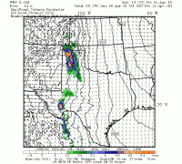
TTU WRF dom_2km_all_stp_f14.gif Like Ethan...I am not chasing today but do agree with his target area. Here is the SigTor forecast for 16/00Z from the 12Z run of the Texas Tech 3-KM WRF. Values are generally 5+...fairly impressive with the somewhat limited moisture. It is likely more from the shear and helicity.

View attachment 12487
 
Last edited:
I think moisture will be the big problem today, but I might be wrong. Td's in the low to mid 50's might be ok later on this evening when the LLJ gets going and the bases lower due to less T-Td spreads.
 
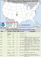
I'd like to make a suggestion to the mods/owners of Stormtrack that I think would be educational. Each Target Area Event thread should have (as its final post) a screen shot of the SPC storm reports for the day.
Obviously user reports would still belong in a REPORTS thread (and a link could be provided from the end of the Target Area Event thread to the Reports thread, when there is one). But just a graphic of the Reports would serve to let others see whose forecasts verified.

d933cdcfdfe0f115c7c859f9ca75b783.png
 
Back
Top