• While Stormtrack has discontinued its hosting of SpotterNetwork support on the forums, keep in mind that support for SpotterNetwork issues is available by emailing [email protected].

2016-04-10 EVENT: KS/OK/TX

Joined
Mar 30, 2008
Messages
1,488
Location
Norman, OK
Just perused over the 12Z NAM, and while it doesn't look super great, some supercells could possibly be had. The major concern to me is shortwave ridging through 00Z, but things should get better towards 03Z Monday. Subsidence with early morning storms seems to leave the atmosphere kind of dry until later in the day.

Cape nearing 1500-2000 according to the NAM as well as 40-50 knots of WSW flow at 500mb and decent flow at 850 should lead to supercell development along a dryline in West Texas and perhaps outflow boundaries from earlier storms.

Right now if I were to go out I would be targeting Aspermont, TX around 00-03Z. Bring your flashlights folks.
 
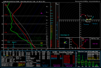
I've been eyeballing a marginal local chase on this day so I'll throw in my 2 cents. NAM is actually showing an area of decent 0-1 km SRH in eastern Kansas late, with a little blip popping around Emporia at 00z. I popped a sounding there and this is what I got:
fc5acb2970501b5a130c0eaf16276ed1.png

Of course, there's the dreaded southwest 850s and veered surface winds, along with various other issues, but if storms are moving southeast SRH should be sufficient for tubes. Also, 20-30 kts of 0-1km shear with CAPE values possibly exceeding 2500 is nothing to ignore. Only reason I'm considering this kind of a setup is because it's about an hour drive for me and on a Sunday, so I'll have probably until 3 or 4 pm to decide whether I want to go after it. Not getting excited at all, but it's April and I'm not seeing anything very impressive for the rest of the month, so I'll be taking anything I can get.
 
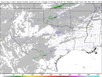
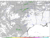
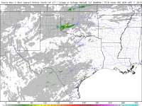
Last two runs of the 4km NAM have been painting an interesting scenario for central OK. They have developed a supercell after 00z that tracks toward OKC metro.

18z run:
e7fced530c8f2e31a1a75cb4667746fd.png

And the 00z run:
3f412a83e323b9e4dae12723b99577cf.png

Needless to say, the 4km NAM is liking something in that area. Winds are backed and moisture looks to be good. I will be interested to see if other high res models pick up on something similar.
 
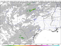
Make that 3 model runs in a row showing supercell over central OK after sunset. 12z should be out soon. It will be interesting to see of models have this right (scary) or not.

693043f3f498e7e34b332c9110924db9.png

12z run is in. Looks similar but 100 miles further west.

3884e4ac5903c9f7939d70e996573dde.png
 
Last edited:
Interesting scenario by looking at morning data - 12Z RAOBS show very steep lapse rates of around 8 as a moisture return looks to be progressing, albeit not as much as I'd like. Surface dewpoints are around 60F, give or take 3 degrees throughout most of North Texas and Oklahoma.

With that said, water vapor shows a increasingly negative tilt trough centered over the baja california rapidly moving east as the ridge seems to be pushing off further east as well. I believe we'll start seeing height falls over the warm sector in the 21-00Z range, but especially after 00Z as that ridge pushes east.

Until then, visible satellite looks pretty clear, and temperatures should warm well into the 80s and maybe even 90s across NW TX and SW OK. This should keep dewpoint spreads a little high for today, with 20-30F spreads. I would expect storms to initiate after 21Z and mature slowly as things come together closer to 00Z. Low level jet ramping up at 00Z really seems to create large curve hodographs, especially in Oklahoma, as critical angles seem to be really close to 90 degrees, and NAM (which is probably over estimating - but perhaps not) is showing 3000+ J/KG MLCAPE.

My initial thought is to head towards Altus, OK later this afternoon in the 2-3pm range and wait. I would not be super eager to be on these storms right away, so it would be more of a wait and see on which one becomes more dominant.

Hail will be quite large today it seems with good heating, lapse rates and associated CAPE. Few people will be getting new windshields tomorrow I think.
 
Back
Top