2016-02-02 EVENT: MS/AL/TN/IL/IN/KY

Joined
Jan 12, 2015
Messages
51
Quite a difficult and complicated forecast for parts of Dixie Alley has been manifesting itself for the past week or so, but I figured there was enough certainty to start a thread for this event.

As it stands right now, it looks like anywhere from 750-1500 J/KG of CAPE will push northward across parts of Mississippi, Alabama, and Tennessee Tuesday afternoon and evening, with a strong LLJ racing out of the southwest. The biggest uncertainties with the forecast appears to be the helicity values and location of the 500mb trough, as previous runs pulled it significantly to the NW before dropping it back to the SE again. Nonetheless, the 4km NAM seemed to support the idea of a broken line of cells forming across MS and western TN during the day Tuesday, before pushing this line east across AL Tuesday evening. Lapse rates generally seem to be adequate for the updrafts to sustain themselves, but there's been some uncertainty between the models in that regard.

All-in-all, this system has potential to produce perhaps a strong tornado or two across Dixie Alley, but the uncertain lapse rates is leading me to believe that bust potential could be higher than usual as well with this system.
 
I'm actually watching the northern target on this one for a local "dust off the gear" type chase. I call it that, but I do think there is a genuine threat for one or two tornadic supercells in southern Illinois and Indiana tomorrow afternoon and evening. MODS may want to add IL/IN/KY to the title on this thread.

At 21z the main surface low is forecast to be situated over northern Missouri - with a second lead wave located over central Illinois and associated warm front draped across Interstate 70 in south-central Illinois. South of this warm front we'll see meager, but perhaps doable instability with surface temperatures reaching the lower to middle 60s, and tds in the 50-55 range. Temperatures aloft also aren't as ideal with the main wave and colder temperatures aloft lagging off to the west still. Worth noting that while A is not necessarily A here - the NAM has actually been under-forecasting surface maximum temperatures with a cool bias the last several days. So with a sprinkle of wish casting, we could be dealing with a situation where we actually end up with greater than forecast surface instability in this northern target - which coupled with the forecast wind fields could be a big difference maker.

All of this being said, it does appear we'll see sufficient insolation over southern Illinois to generate enough low level instability for a few intense updrafts. Best case scenario - we do see sufficient heating to see a few sustained storms that can tap into the more than abundant low level shear and produce a few tornadoes. A just as likely scenario however is that we remain just a tad too cool, and end up with quick moving lines of over-sheared shallow convection perhaps producing spotty damaging winds. This is actually something the GFS seems to be a little bit more into. The GFS forecast a more broad, but shallow warm sector and likely some fast moving spotty wind damage producing lines across the Ohio River Valley.

Certainly not something that I expect to get many out the door - but I am an hours drive away from the warm sector, and with a wedding coming up late this spring I figure I don't need to be turning my nose up at any pre-season setups with a genuine tornado threat an hour away.

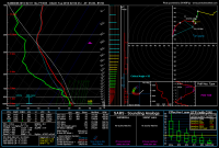
I've attached a NAM forecast sounding for 21Z near Olney, IL which has been general target for something interesting the last couple of days.
 

Attachments

  • 12_NAM_033_38.37,-88.5_severe_ml.png
    12_NAM_033_38.37,-88.5_severe_ml.png
    161 KB · Views: 147
Andrew those capes on the reading look too low for tornadic development although the wind shear is incredible. I've tried to talk to people about minimum levels for tornadic development but have come up short. Usually when they see capes of 600 or less they scoff at it.
 
I definitely wouldn't be surprised to see a few tornado reports come out of the warm sector tomorrow. If I lived closer, or if this were on a Saturday, I would absolutely give this setup a fair chance and a chase. I would likely target somewhere in southwestern Tennessee. If the TDs can make it into the low-mid 60s up in far northern MS and southwest TN, I think you'll have sufficient cape for tornadoes. It is February so not much needs to be said about the shear. One issue definitely could be storm mode though. But, if a few isolated updrafts can breach the cap ahead of the main line of forcing, then it could be game on. Otherwise we may be looking at more QLCS type spin ups as the SPC mentions in their current D1 outlook.
08b9381a03a9aff44052f2d0410433fd.png
6fae6681a8a44c42e9cc1bd08fd9041d.png
 
Last edited:
The major thing I've noticed with the warm front/surface cyclone play in MO/IL/IN is that the storm motion vector is surprisingly favorable given the rapidly advancing warm front solution the GFS has been crapping out these past few runs. That said, the speed shear further south into western Kentucky and western Tennessee looks strong enough that hodos are becoming sickle-shaped with very little turning like you'd expect for a Dixie setup this time of year and the southern play has proximity to the great moisture/higher surface temps further south along the Mississippi.

As of right now, northern Mississippi still looks like the best target speaking strictly from a meteorological perspective. The issue is the jank local road network coupled with a few national forests north and east of Oxford that will likely make it troublesome given the storm speeds.
 
Models have been slowing this system with each run, nudging the extent/richness of the warm sector farther north and west. I'd expect SPC may adjust accordingly tonight. It appears that 1000j/kg of SbCAPE reaching I-64 tomorrow may not be out of the question.
 
Well, having seen enough tornadoes in low cape (and I me an LOW cape) scenarios here in the Midwest, I'm not really in the business of arguing minimum cape values at face value.

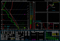
That said, 18z run continues to slow the system down and create a broader unstable warm sector in the southern Illinois target area. Here is a sounding from near Salem, IL valid at 21z Tuesday afternoon.

558ec31bebadc75398f17a78123b8b2b.png

Should something like this slower/broader solution actually unfold - I think a bigger chunk of southeast Illinois may see at least a marginal risk of tornadoes tomorrow afternoon and evening - perhaps along and south of a St. Louis to Danville line between 3 PM and 9 PM tomorrow.
 
The weak lapse rates were a rather common problem last year. As Andrew said, the timing of that 500 mb trough is important as well.

To think, exactly 5 years ago a good chunk of the central part of the country was thinking about a possible blizzard (though part of the central and northern plains are thinking about that now lol), now it's severe weather! What a difference 5 years makes! XD
 
Andrew those capes on the reading look too low for tornadic development although the wind shear is incredible. I've tried to talk to people about minimum levels for tornadic development but have come up short. Usually when they see capes of 600 or less they scoff at it.

My Illinois tornado on 12/23/15 in an environment with CAPE of less than 500 joules would disagree. There's so much more to it than just a face value of CAPE.

Agreed generally with Andrew's and Dan's takes. If 18z runs actually come to fruition, I'd be shocked to *not* see a couple legitimate tornado reports in Southern Illinois tomorrow -- perhaps as far north as I-70 or even a bit further north. Is it ideal? Nah. It's February. But it generally takes a legitimate threat to get me out the door this early in the year, and I'm probably 80/20 to chasing at this point.
 
When you get these high shear, low cape events in Dixie Alley a very small difference in cape values can mean the difference between high end outbreak and a marginal tornado threat. It's making for a very complicated setup. I know NWS JAN is going all out screaming outbreak, even trying to talk SPC to go moderate. The latest graphic they have up uses their "extreme" wording. Problem is, you have models like the GFS showing 500-1000 ML cape which is enough to produce in this type of environment but still marginal and the Nam pushing those cape values up to 1500 with the 4k and Euro showing pockets closer to 2000 it's a massive difference. You get 2000 cape in tomorrow's environment then JAN's worries are quite justified. The wind profiles are quite nice, decent cap in place, partial clearing and a big pacific front pushing through with 70-90 knots at 850mb and it's asking for trouble. One thing that usually allows the low cape setups to work are extremely low LCL levels and the soundings I've been pulling aren't the ground scraping LCL's you normally see with these setups and while they are still low I have to wonder if that will have an impact.

So with all that said, if you assume a middle ground on models then everything appears to be right on the line between some higher end setups and more marginal days. My thinking is the highest probability of tornadoes will be in N. Ms/Tn and even into Ky and edges of Ar/Mo. If you are looking at the higher probability of strong tornadoes then I really think Ms/Tn is the place to be and the best storm of the day could very well be in central to eastern Ms where not much attention is being paid. Like cape values, storm initiation is all over the map depending on the model. The environment peaks out between 18-00z depending on the model. They all pretty much agree that after 18z moisture slowly continues to get better while MLLR continue to fall. So there are a lot of red flags with this system just 20 or so hours out. The good news is you have a pretty good consensus there will be supercells and the wind fields are great over a large area. There is no waiting for a LLJ to nose in or needing a cap to hold things off to get primed up, worrying about morning convection messing things up, messy storm mode, etc.

I think the morning runs and getting in range of the HRRR will start to give a better idea where model consensus should be but right now, 50 tornado reports wouldn't surprise me one bit with several of them violent but neither would very few reports with all of them brief.

As for chasing, I think it's going to be a cape hunt, find the best cape, get on the nose of it and try to keep up. I just really hope it's in the delta during the day as opposed to the trees at night. Unless there are multiple long tracked tornadoes tomorrow, I think there are going to be a lot of chasers who struck out, myself included.
 
One thing I've noticed with today's model trends is the formation of a shortwave trough rounding the base of the main one and maybe contributing to the development of a secondary low somewhere over AR/TN. If this were to occur, it would likely enhance low-level shear across the southern part of the warm sector and lead to a more discrete storm mode as well as a higher chance of tornadic development further south into perhaps central MS and AL. In all likelihood it's going to come down to the meager instability and lapse rates, and if storms are able to maintain their updrafts in this environment. Just a slight underverification of these values and we could be looking at a bust for a fairly large area.
 
I will be sitting this event out as it looks like the best threat is going to be pretty far south, perhaps a marginal threat in far Southeast IL (and I've already got stuff to do at home :/). Nonetheless if I were chasing I think I would target somewhere in Western TN up towards perhaps Western KY. I think Western Tennessee is a good starting point, some decently flat lands there to work with. 4km NAM has been showing some cells firing here in fairly decent parameters, question will be whether they are QLCS or can take advantage of those fine parameters. Good luck to all those heading out and be safe.
 
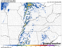
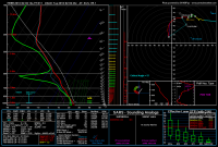
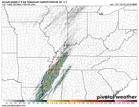
It is looking like today could become quite volatile in areas of Dixie Alley. TDs are already in the upper 50s to low 60s in the northern parts of the warm sector, and mid 60s to even upper 60s in the southern parts. The visible satellite imagery shows that there are cloud breaks this morning and this should allow for some decent insolation to occur in parts of the risk area. So it looks like were going to have more than sufficient moisture and possibly even some higher end cape values for February... If we are to believe the HRRR, the latest run is forecasting upwards of 1500 SBCAPE in northern MS and W Tennessee. The 12z NAM is now showing 1000-2000 SBCAPE in parts of the warm sector. If discrete cells can be the dominant storm mode for a 2 to 3 hour window this afternoon, look out. Here is a nice looking sounding from the HRRR. Also, a plot of the scary looking UDH tracks for later this afternoon. I don't take those too seriously, but I have noticed that lately when the HRRR shows multiple runs of strong UDH tracks, it becomes a very interesting afternoon. Sadly, I am stuck up here in the blizzard portion of this storm system. I just can't bring myself to use vacation time on Dixie Alley in February... @#$% :(
4524a0ffcdc5f63f21252b668efc38e4.png
:eek::eek::eek::eek::eek::eek::eek::eek:
a3dc71a01f3a067857fc69fd41671a59.png
 
Last edited:
Interesting to me is that yet again in a big system like this we seemed to have only 1 storm in the "sweet spot" that produced, while a bunch of other storms were good looking, had warnings but never got it done.
 
Back
Top