R R Smith
EF0
An active weather pattern along the West Coast created conditions which were potentially good for post frontal supercells in the Sacramento Valley on January 13th. A typical post frontal cold pool severe setup was in place as acknowledged by SPC's marginal risk and 2% tornado risk. The primary concern was whether or not adequate instability would be in place as the forecast was for CAPE values at between 250-500 J/kg providing some sun breaks occurred following the frontal passage. Strong surface southeasterlies were forecast to be in place along the east side of the valley. Any storm that got going would be low topped - with EL's at or under 300 mb.
http://www.spc.noaa.gov/products/outlook/archive/2016/day1otlk_20160113_1300.html
As the valley cleared out with the passage of the front, a line of thunderstorms popped up along an north - south line from central Shasta County down into southern Tehama County. There were two tornado warnings issued - based on radar detected rotation. One cell was just east of Cottonwood (warning issued at 2:18 PM PST) and the other was to the south down near Gerber and Los Molinos (2:22 PM). Neither storm produced a tornado.
I was able to view the southwest side of Cottonwood supercell from Highway 36. There was a nice corkscrew updraft with a long inflow shelf feeding into the storm from the south. As that storm moved off into the foothills, I headed south on Highway 99 to try to catch the Los Molinos storm. I pulled off between Dairyville and Los Molinos and observed a few shallow lowerings as the storm weakened and raced east into the Sierra foothills.

http://www.spc.noaa.gov/products/outlook/archive/2016/day1otlk_20160113_1300.html
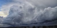
As the valley cleared out with the passage of the front, a line of thunderstorms popped up along an north - south line from central Shasta County down into southern Tehama County. There were two tornado warnings issued - based on radar detected rotation. One cell was just east of Cottonwood (warning issued at 2:18 PM PST) and the other was to the south down near Gerber and Los Molinos (2:22 PM). Neither storm produced a tornado.
I was able to view the southwest side of Cottonwood supercell from Highway 36. There was a nice corkscrew updraft with a long inflow shelf feeding into the storm from the south. As that storm moved off into the foothills, I headed south on Highway 99 to try to catch the Los Molinos storm. I pulled off between Dairyville and Los Molinos and observed a few shallow lowerings as the storm weakened and raced east into the Sierra foothills.