Danny Neal
EF5
Twenty-fifteen was an interesting year for me. A lot of turnover and changes impacted my life, but one thing remained constant….. my love and desire to experience Mother Nature’s best and worst weather. At the beginning of the year I was approached by an individual employed by the National Weather Service Chicago, he offered me a unique opportunity to help out and further enhance my weather skills/knowledge by allowing me to join their social media team. I was also encouraged to apply for NOAA’s Weather Ready Nation Ambassador title with my work on my personal social media page. It was a unique opportunity because most WRN Ambassadors were part of a larger group and not individuals. He pushed me to apply for the position and I had the idea to make our business “Illinois Storm Chasers LLC” designated with that title instead of just “Danny Neal – Northern Illinois Storm Chaser.” This allowed me the flexibility to bring in whomever I wanted to teach and have the resources available to them that I have. My business and storm chase partner Adam Lucio was the first person I approached since it’s our business and I wanted his insight on the designation. He, of course, was all for it! Mid way through March, we received our WRN designation and were endorsed by the NWS as a credible and reliable source of information. To me that was huge. My page and my passion for weather has always been aimed toward public safety. Don’t get me wrong, I go out there and chase for me and my own selfish reasons; but I also make sure I can warn in whatever way that I can. So having that bit of credibility from the “major league” club was a huge pat on the back and step in the right direction. Some people have said and will say that WRN is not an “individual” or “official” position within the weather service. I agree. It is a volunteer position that gives me more experience than a paycheck ever could. To those that want to stir the pot and say I act like an official NOAA employee, I say worry about your own miserable life and try to regain some sort of intergrity to do your job without bringing others down around you. I am all about high morale and encouragement, this is why I have no patience or tolerence for belitting people or haters from another state that need several other people to do the job that I do alone.
If I really wanted to get involved with the HAM/SM team, I would have to give up a lot of local chasing events. If I were a new chaser or someone that really didn’t have a lot of success out in field; I would probably have balked on the opportunity and tried to be out in the field as much as I could. My only priority for 2015 was getting out there and seeing a tornado. I have witnessed a tornado every year since 2007 and didn’t want that streak to end. My goal was to spend every local event at the office while using the plains events as an excuse to get out there away from local responsiblities. My professional page carries a certain responsiblity. It wasn’t by design or intention, but it rapidly evolved into a go to source for weather information. The way my page works is that I use blended information from the NWS, NOAA, and myself to make forecasts, give warnings, and other safety information. All of my forecasts come from me, but I will definitely share the message of the National Weather Service by redistributing their warnings, graphics, and information any chance I can get.
2015 started off slow in terms of severe weather both locally and nationally. It wasn’t until April 9th that our local area was threatened by significant severe weather. It was my first opportunity to volunteer at the NWS and to get my feet wet with how the office works during a severe weather day. It was QUITE an experience to say the least. I won’t get into too many details as I am sure there is some confidentiality issues, but I was very impressed with the men and women that quarterbacked the event. As it turned out, an EF-4 tornado touched down in our western CWA and killed two people. It was the strongest tornado in history to hit that particular area and the first violent tornado to impact the Chicago CWA since the Plainfield F5 of 1990. The tornado itself was highly visible and magnificent looking as evidenced by the hundreds of stunning still and video of the event. I am sure there will be a day that I regret not chasing that day, but I think the experience I received at LOT that day will help me in the future. No regrets.
My first storm chase was plotted to occur during the first week of May. A very strong storm system was progged to eject out into typical tornado alley during the May 7th-10th time frame. After missing a record breaking tornado close to home, my itch to return to the plains was growing. This system looked like a slam dunk to produce multiple tornadoes across the plains and I didn’t want to miss it. We set off for the plains and planned on chasing the 8th, 9th, and possibly the 10th. The 9th was the “big day” but each of the other days had their perks as well.
May 8th: We traveled down to Ben Holcomb’s house in Norman, OK and set up shop. Numerous supercells develped throughout the day and were hammering the Red River Valley. We intercepted a storm near Grandview, Oklahoma just as it produced a brief, but large tornado. We were not able to see the tornado due to the storm’s HP nature. We cat and moused the storm all the way to Waurika. The storm exhibited amazing striated structure with a dark green core. From time to time it would go tornado warned and we would position ourselves to get the best shot of any tornado. We gave up in Waurika and decided to let the storm overtake us and try to get some wind driven hail. The storm was severe warned for 70 MPH winds and baseball sized hail. That would be a nice consolation prize! It just so happened that as we positioned ourselves in a car wash on the outskirts of town that the storm was reintensify and go tornado warned. A strong couplet formed nearly overhead and we watched in awe as a strongly rotating wall cloud passed perilously close to our location. Vorticies danced in the rain as sirens wailed. We couldn’t see the ground due to buildings and trees, but there was a point in time where we did see a long snaky vortex extend down toward the ground. There was a video that showed some power flashes in our area as well. I counted it as a weak tornado. No official survey has been done on it, but based on the evidence I witnessed I believe at least some ground contact occurred. We filmed a beautiful sunset with storm moving off and then headed back into the OKC metro in anticipation for the major outbreak 24 hours from now.
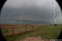

May 9th: To our horror, our set up was contaminated by previous convection across the panhandles. What once looked like a Western Oklahoma/Kansas set up now looked to be Northeast Colorado or Central Texas. We didn’t necessarily want to drive all the way down into Texas because we had our sights set on a set up on the 10th across NE/IA. As it turned out we meandered our way into Western Kansas with hopes of airmass recovery. Instability was building, but there wasn’t enough to over come the insane amount of wind shear. Every single tower that went up was ripped apart and rendered useless. Storms did get under way across Colorado and we hesistated whether we wanted to drive that far west. Unfortunately we pulled the trigger way too late. An amazing localized tornado outbreak was underway across the region and we were just too far away to get any good images. We did see an amazing tornado from over 40 miles away. Hands down one of the best areas to view a tornado from. You can see forever out there and we managed to view a rather large tornado from nearly 50 miles away! We made it to the storm from an hour away just as it crossed the cold side of the boundary and died. Our temperatures dropped from the 70’s into the 30’s and ice pellets started to fall from the sky. It was disgusting! We battled slow traffic and terrible roads for another 45 minutes until we noticed a storm developing another hour to our east. It was nearing sunset and we were snake bitten and needed to salvage the day. We flew east on I 70 and managed to intercept a supercell that went on to drop 7 tornadoes right at dusk. It wasn’t ideal, but we managed to score a consolation prize.
June 15th: Wasn’t actually a storm chase by design. I set off on a trip with my girlfriend to surprise her for her birthday. I teamed up with her mom, sister, and cousin to fly in her best friend from Houston and surprise her with a few days to get away from it all and fish and camp down at Lake Shelbyville. We left the 14th and came home late afternoon the 15th. Storm were predicted each of those days so I brought my camera gear with me and the rest of my chasing supplies. As we were coming home storms were developing all over, but were not expected to become severe. In fact, a heavy rain threat would be lead to flooding over a large portion of the area. We stopped off a local store to grab some supplies for dinner just as a tornado warning was issued for the city of Chicago. I was completely shocked by this and couldn’t believe the hooking supercell that was moving across the southside. This storm actually produced a waterspout just off the Chicago shoreline. We drove back to Peotone and began dinner when a new tornado warning was issued for Will County. Right where I was…. I ran outside and hopped in the car and drove a mile to I 57 where we witnessed a small rope tornado off in the distance. It quickly dissipated and the storm fell apart. A great way to cap off a wonderful weekend!
August 18th: Full account found here: http://chicagostormchaser.com/20150818/
Totals:
Miles: 3,500
Tornadoes: 9
Hail: .75″
Winds: 75 MPH
States: IL, MO, NE, IA, KS, TX, OK, CO
Firsts: Colorado tornado
If I really wanted to get involved with the HAM/SM team, I would have to give up a lot of local chasing events. If I were a new chaser or someone that really didn’t have a lot of success out in field; I would probably have balked on the opportunity and tried to be out in the field as much as I could. My only priority for 2015 was getting out there and seeing a tornado. I have witnessed a tornado every year since 2007 and didn’t want that streak to end. My goal was to spend every local event at the office while using the plains events as an excuse to get out there away from local responsiblities. My professional page carries a certain responsiblity. It wasn’t by design or intention, but it rapidly evolved into a go to source for weather information. The way my page works is that I use blended information from the NWS, NOAA, and myself to make forecasts, give warnings, and other safety information. All of my forecasts come from me, but I will definitely share the message of the National Weather Service by redistributing their warnings, graphics, and information any chance I can get.
2015 started off slow in terms of severe weather both locally and nationally. It wasn’t until April 9th that our local area was threatened by significant severe weather. It was my first opportunity to volunteer at the NWS and to get my feet wet with how the office works during a severe weather day. It was QUITE an experience to say the least. I won’t get into too many details as I am sure there is some confidentiality issues, but I was very impressed with the men and women that quarterbacked the event. As it turned out, an EF-4 tornado touched down in our western CWA and killed two people. It was the strongest tornado in history to hit that particular area and the first violent tornado to impact the Chicago CWA since the Plainfield F5 of 1990. The tornado itself was highly visible and magnificent looking as evidenced by the hundreds of stunning still and video of the event. I am sure there will be a day that I regret not chasing that day, but I think the experience I received at LOT that day will help me in the future. No regrets.
My first storm chase was plotted to occur during the first week of May. A very strong storm system was progged to eject out into typical tornado alley during the May 7th-10th time frame. After missing a record breaking tornado close to home, my itch to return to the plains was growing. This system looked like a slam dunk to produce multiple tornadoes across the plains and I didn’t want to miss it. We set off for the plains and planned on chasing the 8th, 9th, and possibly the 10th. The 9th was the “big day” but each of the other days had their perks as well.
May 8th: We traveled down to Ben Holcomb’s house in Norman, OK and set up shop. Numerous supercells develped throughout the day and were hammering the Red River Valley. We intercepted a storm near Grandview, Oklahoma just as it produced a brief, but large tornado. We were not able to see the tornado due to the storm’s HP nature. We cat and moused the storm all the way to Waurika. The storm exhibited amazing striated structure with a dark green core. From time to time it would go tornado warned and we would position ourselves to get the best shot of any tornado. We gave up in Waurika and decided to let the storm overtake us and try to get some wind driven hail. The storm was severe warned for 70 MPH winds and baseball sized hail. That would be a nice consolation prize! It just so happened that as we positioned ourselves in a car wash on the outskirts of town that the storm was reintensify and go tornado warned. A strong couplet formed nearly overhead and we watched in awe as a strongly rotating wall cloud passed perilously close to our location. Vorticies danced in the rain as sirens wailed. We couldn’t see the ground due to buildings and trees, but there was a point in time where we did see a long snaky vortex extend down toward the ground. There was a video that showed some power flashes in our area as well. I counted it as a weak tornado. No official survey has been done on it, but based on the evidence I witnessed I believe at least some ground contact occurred. We filmed a beautiful sunset with storm moving off and then headed back into the OKC metro in anticipation for the major outbreak 24 hours from now.


May 9th: To our horror, our set up was contaminated by previous convection across the panhandles. What once looked like a Western Oklahoma/Kansas set up now looked to be Northeast Colorado or Central Texas. We didn’t necessarily want to drive all the way down into Texas because we had our sights set on a set up on the 10th across NE/IA. As it turned out we meandered our way into Western Kansas with hopes of airmass recovery. Instability was building, but there wasn’t enough to over come the insane amount of wind shear. Every single tower that went up was ripped apart and rendered useless. Storms did get under way across Colorado and we hesistated whether we wanted to drive that far west. Unfortunately we pulled the trigger way too late. An amazing localized tornado outbreak was underway across the region and we were just too far away to get any good images. We did see an amazing tornado from over 40 miles away. Hands down one of the best areas to view a tornado from. You can see forever out there and we managed to view a rather large tornado from nearly 50 miles away! We made it to the storm from an hour away just as it crossed the cold side of the boundary and died. Our temperatures dropped from the 70’s into the 30’s and ice pellets started to fall from the sky. It was disgusting! We battled slow traffic and terrible roads for another 45 minutes until we noticed a storm developing another hour to our east. It was nearing sunset and we were snake bitten and needed to salvage the day. We flew east on I 70 and managed to intercept a supercell that went on to drop 7 tornadoes right at dusk. It wasn’t ideal, but we managed to score a consolation prize.


June 15th: Wasn’t actually a storm chase by design. I set off on a trip with my girlfriend to surprise her for her birthday. I teamed up with her mom, sister, and cousin to fly in her best friend from Houston and surprise her with a few days to get away from it all and fish and camp down at Lake Shelbyville. We left the 14th and came home late afternoon the 15th. Storm were predicted each of those days so I brought my camera gear with me and the rest of my chasing supplies. As we were coming home storms were developing all over, but were not expected to become severe. In fact, a heavy rain threat would be lead to flooding over a large portion of the area. We stopped off a local store to grab some supplies for dinner just as a tornado warning was issued for the city of Chicago. I was completely shocked by this and couldn’t believe the hooking supercell that was moving across the southside. This storm actually produced a waterspout just off the Chicago shoreline. We drove back to Peotone and began dinner when a new tornado warning was issued for Will County. Right where I was…. I ran outside and hopped in the car and drove a mile to I 57 where we witnessed a small rope tornado off in the distance. It quickly dissipated and the storm fell apart. A great way to cap off a wonderful weekend!
August 18th: Full account found here: http://chicagostormchaser.com/20150818/
Totals:
Miles: 3,500
Tornadoes: 9
Hail: .75″
Winds: 75 MPH
States: IL, MO, NE, IA, KS, TX, OK, CO
Firsts: Colorado tornado

