Dan Robinson
EF5
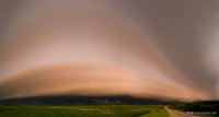
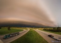
Two report-worthy events for this day. Morning: A line of storms formed near the Mississippi River near Perryville, MO and moved north into Illinois, passing just to the east of St. Louis. The shelf cloud ahead of these storms was already impressive in its own right, as many morning shelves are. But, as the sunrise began peeking through the clouds to the east, the entire shelf cloud formation was bathed in the direct orange glow of the rising sun. This is the first time I've seen a nice shelf cloud front-lit like this, and it was a sight to behold (and photograph)! Below are multi-frame panorama stitches of the shelf cloud before and after sunrise as it moved from crossing I-64 at New Baden to crossing I-70 near Greenville, Illinois:
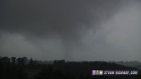
An MCV/surface low hybrid was spinning its way toward St. Louis on the afternoon of the 5th. These are never things to ignore if there is any instability available, so I went over to the Union/Villa Ridge/St. Clair area in Missouri to see if I could find anything interesting. I rarely chase in this area because the terrain is very hilly and forested, and views are hard to come by. I was, however, able to get a nice view of this circulation near Villa Ridge spinning *something* down to the ground, fully condensing at times. I have seen several such events over the years in similar environments. This did not appear to reach the 'violent' or 'damaging' threshold to be called a tornado, in my opinion - but it was certainly a feature that, given more instability, certainly *could* have easily reached tornadic intensity.
In the absence of another term for this, I'll call this a "sub-tornado" Video is here:
More images from this and several other recent events are on my blog:
http://stormhighway.com/blog2015/august615a.php


An MCV/surface low hybrid was spinning its way toward St. Louis on the afternoon of the 5th. These are never things to ignore if there is any instability available, so I went over to the Union/Villa Ridge/St. Clair area in Missouri to see if I could find anything interesting. I rarely chase in this area because the terrain is very hilly and forested, and views are hard to come by. I was, however, able to get a nice view of this circulation near Villa Ridge spinning *something* down to the ground, fully condensing at times. I have seen several such events over the years in similar environments. This did not appear to reach the 'violent' or 'damaging' threshold to be called a tornado, in my opinion - but it was certainly a feature that, given more instability, certainly *could* have easily reached tornadic intensity.
In the absence of another term for this, I'll call this a "sub-tornado" Video is here:

More images from this and several other recent events are on my blog:
http://stormhighway.com/blog2015/august615a.php
