Dan Robinson
EF5
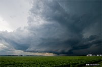
A 2015-reedeming day for me. Started out in Hannibal today. I was on the supercell at its first RFD cycle directly overhead west of town. After a couple more valiant attempts, the storm moved off over the river and out of reach. Due to road flooding concerns along the rivers, I chose to cross into IL and head down to Louisiana via Rockport to re-intercept on the IL side, where I had seen via the IDot site earlier in the morning that that segment was still open. The storm put on a great structure show as it approached and crossed the Mississippi, but the RFD was just overpowering all attempts to organize.

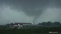
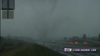
After this point, the storm was clearly too far east of the boundary and not ingesting any of the high-CAPE air to the west, so I crossed back over into Missouri and headed south on 61 to catch up to a new storm that was quickly going nuts. I made it through the northern part of the hook just in time to watch the circulation wrap up and produce just west of the highway at Eolia, then cross.

The tornado appeared to be moving east, but soon became apparent it was turning more south. It crossed the road *again* at some point and was now back on the west side of the highway when I stopped again at the Eolia exit to observe! A snaky subvortex briefly condensed within the broader zone of rotating rain curtains. EDIT: Damage surveys confirm that this was a second, separate tornado, not one erraticly-moving tornado as I'd first believed.

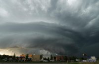
Once again, it appeared as if the tornado turned easterly again, and I had to dart back north on Highway 61 to get out of the way. After losing the entire circulation in heavy rain, I saw that the storm was becoming more linear. So, I dropped south to Wentzville to see if it could re-organize, as its western flank was still very well isolated from other storms to the south. And sure enough, the storm began to 'go nuts' again just north of I-70. This was the structure view at Lake St. Louis:

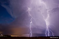
The meso began drawing in surface inflow at a rapid pace just east of here, and I observed what appeared to be a truncated cone tornado deeply embedded in the rain just north of the I-70/370 interchange. I have yet to pull this off off my camera tonight and contrast-enhance it to see if it's apparent. I observed small tree branches and leaves falling from the sky just to the east of here. The storm developed a new circulation to the south, so I dropped down to I-64, then I-55 and finally I-255 to Columbia, IL to keep up with the storm. I did not have visual for a time I was inside the forward flank core, but I did not see any evidence of a tornado during this time (power flashes, etc). Although the storm was now outflow-undercut, it was putting on a top-tier lightning show, so I stopped a couple more times to capture a few frames before heading home.

Video:
After this point, the storm was clearly too far east of the boundary and not ingesting any of the high-CAPE air to the west, so I crossed back over into Missouri and headed south on 61 to catch up to a new storm that was quickly going nuts. I made it through the northern part of the hook just in time to watch the circulation wrap up and produce just west of the highway at Eolia, then cross.
The tornado appeared to be moving east, but soon became apparent it was turning more south. It crossed the road *again* at some point and was now back on the west side of the highway when I stopped again at the Eolia exit to observe! A snaky subvortex briefly condensed within the broader zone of rotating rain curtains. EDIT: Damage surveys confirm that this was a second, separate tornado, not one erraticly-moving tornado as I'd first believed.
Once again, it appeared as if the tornado turned easterly again, and I had to dart back north on Highway 61 to get out of the way. After losing the entire circulation in heavy rain, I saw that the storm was becoming more linear. So, I dropped south to Wentzville to see if it could re-organize, as its western flank was still very well isolated from other storms to the south. And sure enough, the storm began to 'go nuts' again just north of I-70. This was the structure view at Lake St. Louis:
The meso began drawing in surface inflow at a rapid pace just east of here, and I observed what appeared to be a truncated cone tornado deeply embedded in the rain just north of the I-70/370 interchange. I have yet to pull this off off my camera tonight and contrast-enhance it to see if it's apparent. I observed small tree branches and leaves falling from the sky just to the east of here. The storm developed a new circulation to the south, so I dropped down to I-64, then I-55 and finally I-255 to Columbia, IL to keep up with the storm. I did not have visual for a time I was inside the forward flank core, but I did not see any evidence of a tornado during this time (power flashes, etc). Although the storm was now outflow-undercut, it was putting on a top-tier lightning show, so I stopped a couple more times to capture a few frames before heading home.
Video:
Attachments
-
 3ab458dbefc7e7d4e78d476d64940ea6.jpg118.5 KB · Views: 200
 -
 1aa080f0dc1be23d5316003aa0f8ec05.jpg100.5 KB · Views: 165
 -
 185e27ea1f1dc1ad88e5da0cb6bda05f.jpg51.7 KB · Views: 173
 -
 a9151796aaabab1a70cd5e3bbce9c6f4.jpg41.6 KB · Views: 242
 -
 c810b8241617c0debba961d825187fd3.jpg38.6 KB · Views: 198
 -
 3ab458dbefc7e7d4e78d476d64940ea6.jpg118.5 KB · Views: 167
 -
 1aa080f0dc1be23d5316003aa0f8ec05.jpg100.5 KB · Views: 165
 -
 185e27ea1f1dc1ad88e5da0cb6bda05f.jpg51.7 KB · Views: 288
Last edited:


