• While Stormtrack has discontinued its hosting of SpotterNetwork support on the forums, keep in mind that support for SpotterNetwork issues is available by emailing [email protected].

2015-06-20 REPORTS: IA

Joined
Oct 10, 2004
Messages
1,496
Location
Madison, WI
Nick Lorenz, Adrian Beymer and myself chased a severe thunderstorm complex with an embedded HP supercell from shortly after initiation southwest of Grinnell, IA.

The hoped-for discrete mode for at least an hour or two after initiation did not materialize. We watched it try to form a wall cloud several times but new cells would constantly go up to the south, and it quickly became an outflow-dominant cluster. The storms were also highly electrified, producing many close CGs, but it seemed like every time I would get out my video camera they would either stop or we would hit a stretch of trees along the road, so I was only able to get one good one on video.

We stayed just ahead of the complex as it produced significant severe hail and wind in the New Sharon/Pella/Eddyville/Oskaloosa region before breaking off the chase and heading north toward home as the complex turned to the southeast. We were treated to a beautiful mammatus display as the setting sun broke out behind the storms.


Near Pella:


Near Eddyville:


I also chased this day and didn't really come away with much to show for it, at least storm wise. From its initiation southwest of Grinnell, Iowa it actually looked fairly good to start out and then seemed to go outflow dominant with storm mode turning from supercellular to linear fairly quickly. I should add that the lightning on this storm kept me in the vehicle much of my chase because of its close proximity. Heading home, I shot several photos near sunset and of the lightning after dark that actually turned out better than the chase itself! Check em out below!

Iowa%20Wall%20Cloud_zpshdvsuval.jpg

Storm in Southeast Iowa that was fairly disorganized..

Rainbow%20Lightning_zpsgt88quas.jpg

Rainbow/Lightning/Sunset in Southeast Iowa

Sunset%20Apocolypse_zps0vefwrdw.jpg

Sunset near Mount Pleasant, Iowa after the chase

June%2020th%20Lightning_zpsiz17ckfp.jpg

Barrage of cloud to ground strikes a few miles from home in Western IL
 
I spent awhile waiting for the storms in Iowa after leaving at noon. The storms ended up forming farther west than I had hoped and were initially moving very slow. I didn't want to drive further away from home to pursue them so I just waited near Washington and Mount Pleasant for the storms to come to me.

I watched the anvil go up and some very defined mammatus clouds formed:


Bubbling Mammatus
by Kevin Palmer, on Flickr

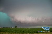
The storms very quickly congealed into a line and there was hardly ever a tornado threat. A very intense bow echo formed and I thought it would be easy to shoot a time lapse of it approaching. But by the time it approached Mount Pleasant a bunch of smaller storms started popping up in front of it so I no longer had a clean view of the approaching shelf. I raced east and after crossing the Mississippi I finally let the storm overtake me near Gladstone. I had just a couple minutes to photograph the shelf cloud as the driving rain started interfering. The shelf had a very green rain core and was one of the fastest I've ever seen. I have no doubt the winds were 70 mph as my car was shaking.


Green Monster
by Kevin Palmer, on Flickr

While waiting for the rain to end I noticed a warm glow emerging in the west. It turned into one of the best sunsets I've ever seen. The vivid colors lingered for over 30 minutes as lightning crawled across the sky. I didn't even try to shoot the massive rainbow that had formed behind me because I was so in awe of the colors in front of me.


Luminous
by Kevin Palmer, on Flickr


There Are No Words
by Kevin Palmer, on Flickr
 
Back
Top