kevin-palmer
EF2
Today there was just enough cape and wind shear in Eastern Illinois to make things interesting. I've gone out and seen nothing on a lot of days like today. But the fact that there were no more storms in the forecast for the area after today pushed me out the door. Plus Eastern Illinois is a perfect area to chase in. It's extremely flat with very few trees and a decent road network. I targeted the area where the strongest bulk shear (35 knots) and the warmest surface temps overlapped.
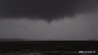
Leaving at 11AM, I drove past the metro area of Champaign and made it to St. Joseph. This was exactly where I needed to be see the forming supercell coming up from the southwest. After driving north a few miles I waited for it to get closer. Every radar return looked different, sometimes showing strong rotation and sometimes showing hardly any at all. Just after I setup to shoot a time lapse around 2PM I noticed a funnel forming underneath the base. There was no obvious wall cloud at this time. The funnel was very small and high based at first. Then it became long and skinny and reached at least 2/3 of the way to the ground as bands of rain rotated beneath. After that the funnel became wider at the top before diseappearing into the rain altogether lasting about 5 minutes. It danced right across the frame in my time lapse. I tried to follow the storm a bit further but I lost it. I shot a few more storms afterwards but the funnel was the highlight. I've never seen one this clear and defined before.

Ogden Supercell by Kevin Palmer, on Flickr

Off to Oz by Kevin Palmer, on Flickr

Pencil Thin Funnel by Kevin Palmer, on Flickr

Rotating Rain Bands by Kevin Palmer, on Flickr
Leaving at 11AM, I drove past the metro area of Champaign and made it to St. Joseph. This was exactly where I needed to be see the forming supercell coming up from the southwest. After driving north a few miles I waited for it to get closer. Every radar return looked different, sometimes showing strong rotation and sometimes showing hardly any at all. Just after I setup to shoot a time lapse around 2PM I noticed a funnel forming underneath the base. There was no obvious wall cloud at this time. The funnel was very small and high based at first. Then it became long and skinny and reached at least 2/3 of the way to the ground as bands of rain rotated beneath. After that the funnel became wider at the top before diseappearing into the rain altogether lasting about 5 minutes. It danced right across the frame in my time lapse. I tried to follow the storm a bit further but I lost it. I shot a few more storms afterwards but the funnel was the highlight. I've never seen one this clear and defined before.

Ogden Supercell by Kevin Palmer, on Flickr

Off to Oz by Kevin Palmer, on Flickr

Pencil Thin Funnel by Kevin Palmer, on Flickr

Rotating Rain Bands by Kevin Palmer, on Flickr

