chrisbray
EF4
I know anyone lucky enough to be in TX today will post a report at some point, so I will include them.
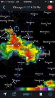
I don't have much to report per say, but as I was getting off work around 4:30 I noticed a sever warned storm complex moving in to my county in Illinois, so I said screw it, I'll drive 15 minutes in to the countryside and see what happens.
By the time the storm got close, the severe warning was dropped but I could see a gust front emerging. It was nice to just relax in front of a beautiful storm for a bit and know there was no immediate threat. I repositioned a bit to the north and east to avoid the rain, and watched the front come in again.
 IMG_0255 by inflow55, on Flickr
Just a couple shots with the iPhone. There was hardly even a noticeable wind shift behind the front after I let it pass over me. On the way back, I did drive through the core and encounter some pea to blueberry sized hail briefly. Then I grabbed some tacos and called it a night!
I don't have much to report per say, but as I was getting off work around 4:30 I noticed a sever warned storm complex moving in to my county in Illinois, so I said screw it, I'll drive 15 minutes in to the countryside and see what happens.
By the time the storm got close, the severe warning was dropped but I could see a gust front emerging. It was nice to just relax in front of a beautiful storm for a bit and know there was no immediate threat. I repositioned a bit to the north and east to avoid the rain, and watched the front come in again.
IMG_0255 by inflow55, on FlickrJust a couple shots with the iPhone. There was hardly even a noticeable wind shift behind the front after I let it pass over me. On the way back, I did drive through the core and encounter some pea to blueberry sized hail briefly. Then I grabbed some tacos and called it a night!