2014-05-26 REPORTS: TX/ND

Joined
Aug 16, 2009
Messages
814
Location
Amarillo, TX
We left my house here in AMA around 12pm with my target being Big Spring. Kinda went with the HRRR on this day. I knew the area would have OFBs and some good dynamics from that low. Not only that but the 12z NAM had a meso-low sitting around MAF. We got to Lubbock when the storms fired out west of Andrews. When we got to the storm, it went tornado warned. We followed this storm until Big Spring. On the way, we saw a brief tornado NW of Big Spring (shown in video). We broke off and went to the supercell further west. We got another confirmed tornado east of Garden City. There were also some suspicious looking areas between Big Spring and Garden City off to the west. One of my pictures I took on my phone was time stamped at 5:43pm, about 10 minutes before the multi-vortex tornado report. When that storm followed us into Sterling City, we again broke off and went west. We got some amazing supercell structure before leaving that storm to once again go west. By this time all the tor warnings were expired and we were treated to an amazing sunset and some really thick hail fog. Overall a great chase in an area of TX I've never chased in.

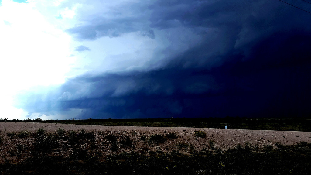
Suspicious area, high contrast:
2014-05-27%2012.06.52-XL.jpg


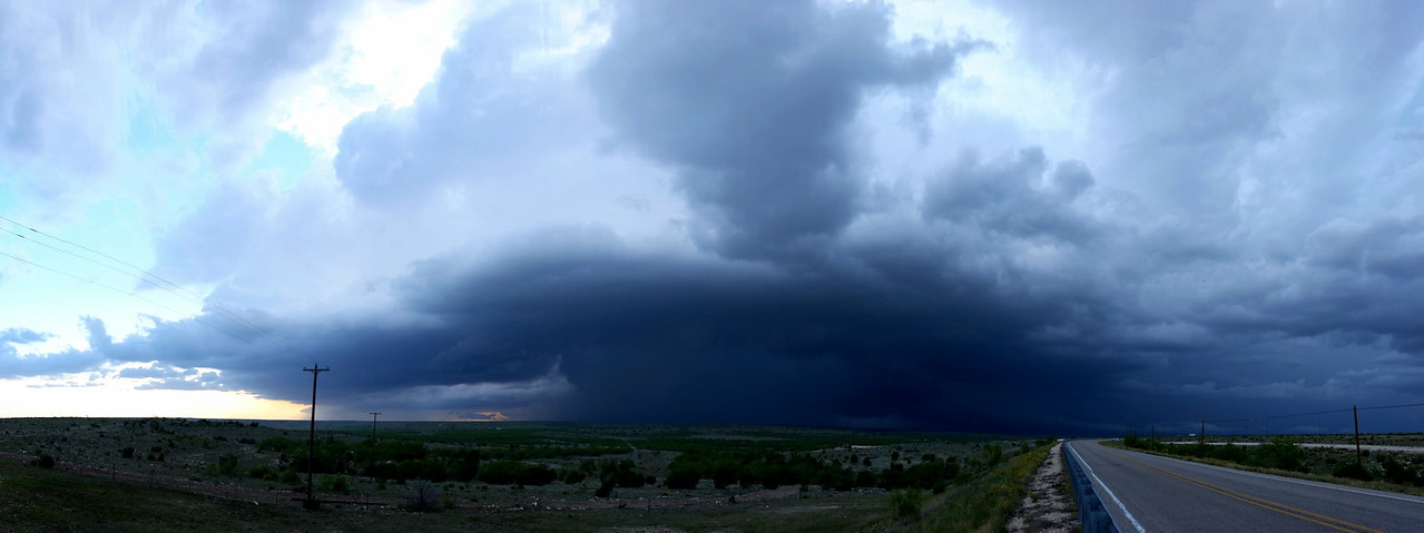
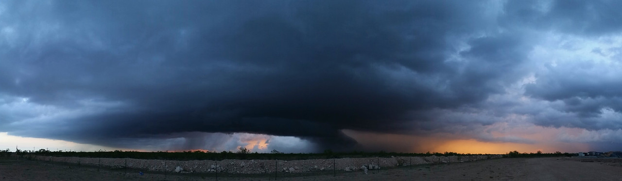
Some panoramics of 2 different supercells:
2014-05-27%2012.01.36-X2.jpg


2014-05-27%2012.00.16-X2.jpg


Rest of the photos from this chase, all taken by my chase partner and girlfriend. Click here.

And video of the chase.
Watch video >
 
Last edited by a moderator:
2014-05-26 REPORTS: TX

Feel free to add North Dakota, if anyone has anything from the now-famous oilfield tornado.

I caught the Big Spring storm that allegedly had a rain-wrapped tornado on I-20 near Coahoma. Whoever got close enough to report a rain-wrapped tornado in an aquamarine-glowing, southeast-moving supercell on an east-west Interstate--may your windshield rest in peace. This was the less gutsy view from 2-3 miles south of I-20 along County Road 262/371 at 2238 UTC, when the tornado was reported:

DSC_0271.jpg

A few minutes later, back on FM 670 to bail south:

DSC_0278.jpg

I dropped south of Sterling City on Highway 163 for the next storm to the west, after being asked by the local newspaper editor why sirens weren't going off (good question) and being warned by a resident that "There's five tornadas in there!" I never saw five tornadoes, just a bizarre little feature south of where it seemed the main updraft should be. This elongated lowering hardly seemed attached to the cloud base at all, but was visibly rotating and rising (0008 UTC):

DSC_0300.jpg

The storm was chucking half-dollar hail out in front of it. With that, the chasers/spotters/locals-with-kids-in-tow logjam on 163, and the up-and-down terrain, I never got a good view as the storm crossed the road. Stopping well south of it, I took a photo at 0024 UTC that shows a thin, faint feature in an area where a tornado could be. I hardly noticed it at the time but later saw SPC tornado reports at 0013, 0015, and 0031 UTC, and sent it on to the San Angelo WFO in case they had other reports. Anyone here get a better look or have more info? This is looking north-northeast from 163 some 20-30 miles or so south of Sterling City at 0024 UTC:

DSC_0314 copy.jpg

After that it was back north a few miles on 163 for tornado-warned supercell #3 and the longest inflow tail of all time (0100 UTC):

DSC_0322.jpg

At 0105 UTC, a tornado was reported 15 WSW Sterling City. I have to assume it was this storm. Nothing was visible from 163 and the view was pretty much unchanged from above, just a big meso and beaver tail.
 
The first storm went up early in Martin County on 176. This is a land spout on a flanking line near Tarzan TX. just North of 176.
Ya7dPFg.jpg


The next storm (1st Garden City storm) Crossed I20 near Stanton TX and tornado warned. This is as it had just crossed the interstate.
WuXGlYG.jpg


Looking West back down 158 from Sterling City as the storm goes through Garden City.
g7lXBGK.jpg


We then went through Sterling City and got in front of the storm on 163 as it comes straight at us. Had to abandon this position due to hail.
Watch video >
 
Brindley and I chased a couple of HP supercells from north of Midland to Sterling City, Texas. Lots of dramatic HP gust front, wall clouds, and supercell structure, but we didn't see anything distinctly tornadic, despite the numerous tornado reports that were coming in on the storm. Full log, photos, map, and stats:

http://skip.cc/chase/140526/

Photography is courtesy Jennifer Brindley Ubl

14052603.jpg

14052609.jpg

14052610.jpg

14052611.jpg


Also of note is that this chase had some of the worst chaser convergence traffic of the year. There was just one paved highway running through the area south of Big Spring with one dominant supercell, and the road was already quite busy to begin with. There were no good pull off spots so the shoulders were lined with chasers wherever there was a view. We saw a couple of dangerous maneuvers, including this black vehicle that crossed in front of oncoming traffic and darted into a spot between parked vehicles... all the crowding and erratic movement was for a view of scuddy HP gust front. Despite the numerous tornado reports that came in on this storm, I didn't see any photogenic shots of them beyond dust whirls.

14052613.jpg
 
...Also of note is that this chase had some of the worst chaser convergence traffic of the year. There was just one paved highway running through the area south of Big Spring with one dominant supercell, and the road was already quite busy to begin with. There were no good pull off spots so the shoulders were lined with chasers wherever there was a view. We saw a couple of dangerous maneuvers, including this black vehicle that crossed in front of oncoming traffic and darted into a spot between parked vehicles... all the crowding and erratic movement was for a view of scuddy HP gust front. Despite the numerous tornado reports that came in on this storm, I didn't see any photogenic shots of them beyond dust whirls.

Skip, are you referring to the road heading east out of Garden City, TX? I was troubled by the traffic on that road as well. I did not see any particularly egregious maneuvers, but the traffic was nearly bumper-to-bumper at one point, heading east with the meso of an ESE-moving supercell behind us. I remember thinking, if this were a more violent storm and/or had a tornado on the ground, we would be screwed. Quite disturbing actually, but the only option would have been to bail south at Garden City and pretty much give the storm up. Also would have been hard to know at that point what awaited us as we moved east.

It was also interesting to see many non-chasing vehicles stop to avoid the core that was encroaching on the road, unaware that the bigger potential danger was actually behind them to the west, not in front of them to the east...

Jim


Sent from my iPad using Tapatalk HD
 
Back
Top