Randy Jennings
Supporter
- Joined
- May 18, 2013
- Messages
- 874
Chased my first supercell of the year on Thursday March 27th, and I didn’t even have to leave my home county (Collin County, TX – just north of Dallas). I wasn’t paying too much attention to the weather this day, as I didn’t really have time to chase that day and the experts all agreed that it would be further to the east. As I walked out of work around 5 PM, I noticed it was much warmer and a lot more humid that it was at lunch. I loaded the convective parameters from the FWD WFO on my phone, and CAPE was nice (don’t remember what it was), but cap was still in place. I went home and right after dinner I noticed a small updraft tower starting to form outside my front window. It was starting to tilt to the east, so it was obvious that there was some decent sheer. I had to get some things done around the house, but decided to check on it every 20 minutes or so. A little while later I looked out the window and saw an impressive supercell to my east with a cumuliform updraft tower, a wispy anvil, and an overshooting top. I grabbed my phone and looked at radar and decided to head out. As I was pulling out of my driveway just after 8 PM, a severe thunderstorm warning was issued and a Skywarn net was started by Collin County ARES.
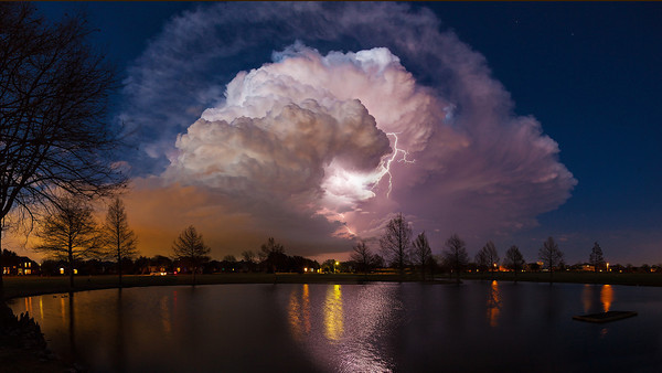
The storm was moving due east along US 380. I decided to stay south of it, so I decided to go north on US 75 from Plano, TX and then head east on Bethany Drive/Lucas Rd, as this is the only way to get across Lake Lavon onto the peninsula of the lake (Lake Lavon is a U shaped lake in eastern Collin county). Here is a picture I took of the cell from Legacy Drive and Alma Drive in Plano, TX.

As I got away from all the houses in Allen, TX and into a more rural area driving towards Lucas, TX, I started to see what looked like a wall cloud to my northeast. It was very hard to see as it was night, and I was in the rear flank still. Luckily there was a lot of lighting. As I crossed over the lake, I had a better view of the updraft base, and there was a wall cloud. I did not see any rotation. I reported it to the Skywarn net. The FWD WFO Radio Desk was glad to get this report because they were seeing some broad rotation on radar and where glad to know they had some eyes on it.
I went north on FM 982 and stopped about 2 miles south of Princeton, TX. I shot some video facing the cell to my north over Princeton. Here is a screen shot from the video showing the wall cloud. I’ve also attached the radar reflectivity and velocity from about the time I took the video. Both radar pics are from the .88 tilt. The .48 tilt did not show rotation (which matches what I saw at the surface). The FWD WFO did not to issue a tornado warning (which I believe was the correct call).
Wall Cloud Photo:
Radar Ref:
Rader Vel:
I couldn’t go any further east without driving north to US 380. Not wanting to drive into the storm, I watched it dissipate from my location on FM 982 as it moved to the east out of the county. Here is my APRS track showing where I was at:

The storm was moving due east along US 380. I decided to stay south of it, so I decided to go north on US 75 from Plano, TX and then head east on Bethany Drive/Lucas Rd, as this is the only way to get across Lake Lavon onto the peninsula of the lake (Lake Lavon is a U shaped lake in eastern Collin county). Here is a picture I took of the cell from Legacy Drive and Alma Drive in Plano, TX.
As I got away from all the houses in Allen, TX and into a more rural area driving towards Lucas, TX, I started to see what looked like a wall cloud to my northeast. It was very hard to see as it was night, and I was in the rear flank still. Luckily there was a lot of lighting. As I crossed over the lake, I had a better view of the updraft base, and there was a wall cloud. I did not see any rotation. I reported it to the Skywarn net. The FWD WFO Radio Desk was glad to get this report because they were seeing some broad rotation on radar and where glad to know they had some eyes on it.
I went north on FM 982 and stopped about 2 miles south of Princeton, TX. I shot some video facing the cell to my north over Princeton. Here is a screen shot from the video showing the wall cloud. I’ve also attached the radar reflectivity and velocity from about the time I took the video. Both radar pics are from the .88 tilt. The .48 tilt did not show rotation (which matches what I saw at the surface). The FWD WFO did not to issue a tornado warning (which I believe was the correct call).
Wall Cloud Photo:
Radar Ref:
Rader Vel:
I couldn’t go any further east without driving north to US 380. Not wanting to drive into the storm, I watched it dissipate from my location on FM 982 as it moved to the east out of the county. Here is my APRS track showing where I was at: