• A friendly and periodic reminder of the rules we use for fostering high SNR and quality conversation and interaction at Stormtrack: Forum rules

    P.S. - Nothing specific happened to prompt this message! No one is in trouble, there are no flame wars in effect, nor any inappropriate conversation ongoing. This is being posted sitewide as a casual refresher.

2011-11-07 REPORTS: OK

Chased the incredible cyclic tornadic supercell that developed SW of Fredrick, Oklahoma with one of my good chase buddies Jeremy Milligan this afternoon. While I've been at this for 17 years, Jeremy was still in search of his first tornado, and after a frustrating spring for him, we broke his tornado virginity in a massive way this afternoon! We were on the initial rain free base as it began to really organize approximately 5 WSW of Fredrick, then at 2:30 the massive wallcloud which was pretty much scraping the ground produced the 1st tornado of 8 we got to chase...some at really close range! The 1st was also the massive multi-vortex/wedge long track tornado which we saw continuously on the ground for over 35 minutes, however there are reports the tornado was on the ground as long as an hour, cant confirm or deny that due to periods of wrapping rain. So some of the "8" we saw, may have been the original "1" for all we know. Either way...INCREDIBLE TORNADOES ALL AFTERNOON/EVENING!!! Also shot the best video I ever have in 17 years of chasing, so much good continuous footage I cant find a thing to edit out, so once I figure that out tomorrow or the next day, I'll post a link in this thread. There were a couple homes heavily damaged NW of Fredrick along with some injured cattle, but for the most part, from what we came across, most of the towns in the path of the 1st violent tornado escaped major damage thanks to it carving its path(s) on the rural fringes of most of them.

S1230001.jpg


S1230002.jpg


S1230003.jpg


S1230007.jpg


S1230013.jpg


S1230051.jpg


S1230075.jpg


S1230083.jpg


S1230088.jpg


S1230135.jpg


S1230136.jpg


S1230173.jpg


S1230176.jpg


***VIDEO LINK: http://www.youtube.com/user/FirstIntercept1972?feature=mhee#p/a/u/0/namEzwV9t2A

*** Full Length Video is in 2 Parts
 
Last edited by a moderator:
We (Emma Fagan, Brian Squitieri, Sam Irons, and myself) could not leave Norman until 3:45pm, but were still able to approach yesterdays cyclic supercell near Ft. Cobb, Oklahoma. The tornado exhibited multiple vorticies several times as it tracked to the west of Ft. Cobb. Just to the northwest of town, the tornado rapidly transformed into a large cone/stove pipe. We continued to follow the tornado northwards as it occluded and dissipated near Ft. Cobb Reservoir. Overall, a very good chase day for November! Congrats to all who saw tornadoes yesterday!

2rqzngx.jpg

Picture taken at 4:57pm CST from .5 miles south of Ft. Cobb, OK and is looking WSW. I was unable to discern if the storm was producing a tornado at this time, but it is highly likely that it was 30 seconds later in this picture.

sqjcwo.jpg

Picture taken at 5:05pm CST from 1.5 miles NW of Ft. Cobb, OK and is looking NW.

2ak9wcx.jpg

This picture was taken by Emma Fagan. It was taken at ~5:05pm CST from a location 1.5 miles NW of Ft. Cobb and is looking NW.

http://i44.tinypic.com/rixaj6.jpg
Picture also taken by Emma Fagan.
 
Last edited by a moderator:
ddds.jpg
ddd.jpg
MV.jpg

I ventured into the Mountain range and caught it ROARING through the mountains...Came over the ridge as an extremely Violent tornado at least 1/4 mile wide drill bit, sending tree's air born. It was on of the most beatiful shots I've seen with a tornado, as it came over the Mountains with all the trees in full color! Then to boot it moved into the wind farm on the road less than 1/4 mile away... Video is absolutely insane, and does if far more justice than the video grabs...Currently traveling so won't get it up for a day or two, but everything will be up on my Facebook page http://www.facebook.com/profile.php?id=100002100483814#!/profile.php?id=100002100483814

Also filmed a half dozen or so other tornadoes, but they all are severely overshadowed my the intercept in the Mountains!
 
Like everyone else, I was on the tornadic supercell as it came out of Frederick, OK. Adam Lucio, Jon Williamson and I punched to the storm from the west and got our first tornado near the town of Tipton. The Tipton tornado was an absolute beauty, and we drove almost right up to it as it roped out.

We headed east and got the Manitou tornado then followed the storm up 183 to 62 to 54 north. Unlike everyone else, we skipped the wildlife refuge and kept north, punching back through at 115/19 and getting an amazing shot of the tornado as it went through the Wind Farm near Saddle Mountain.

We continued north and east, following the storm to Fort Cobb Lake before it fell apart and we gave up, heading to Oklahoma City and the Cimmaron Steakhouse for a VICTORY steak!

Full chase recap

Pictures from November 7th

Videos

Watch video >

Tornado churning through the wind farm

Watch video >
 
Simply an amazing day for November. I lost count of how many tornadoes I saw, but I am going with 9 [may go up or down depending on further analysis]

We tracked tornadoes of all shapes and sizes from Tipton all the way to Binger. Like Doug I have so much video I don't know what to cut out, but here is what I compiled so far. The rope out of the Tipton tornado was the best I have ever personally witnessed.

Watch video >

Here are a couple stills:

320568_10150359066753807_530973806_8438716_1045040  17_n.jpg


388465_10150359323533807_530973806_8440001_7361137  44_n.jpg


Recap is here, but I have a feeling I will be adding to it in the future, as I pretty much quit writing it halfway through and have about 4 or 5 more tornadoes to post pics/video of. WOO!!!

http://www.aerostorms.com/110711-Oklahoma-Tornadoes-in-November.php
 
Monday was definitely the best chase I've had in my 3 years in Oklahoma. Saw a lot of tornadoes in the Spring, but just the quantity and quality of this day is unmatched.

We left Norman at 1pm when we got out of class. Leaving late worked out because we never made it to Altus. The storm went up near Fredrick and we headed to intercept.

We first caught the Tipton tornado. This picture is nice because the wall cloud that produced the big Snyder tornado is beginning to take shape to the left of the original one.

34i1f9g.jpg


Here our video of the Tipton tornado with a well defined satellite tornado (I don't mean to blatantly plug TWC but I don't have this video on my hard drive yet):

http://www.weather.com/weather/videos/storms-42/tornadoes-203/raw-ef2-oklahoma-tornado-22515

When the Tipton tornado began to rope out, it was beautiful!

2nvdtlw.jpg


As the Tipton tornado was roping out to our left, to our right the Snyder tornado first touched down under a gorgeous wall cloud.

a2fyfn.jpg


Here's the Snyder tornado in it's full glory:

2ngeq2a.jpg


We chased the storm into the mountains like most people. Unfortunately none of the pictures turned out well. We caught it again south of Alden and it produced a nice cone in the rain. We then turned around and headed towards Fort Cobb to make a last stand before sunset. When we got there, we chose to stay south of town on a hill looking down into the river valley. It was nice to see it produce several tornadoes from above. It had beautiful structure. Best structure I had seen all day.

642r9c.jpg


Overall, it was a fantastic day to say the least. Must have seen 10+ tornadoes. This will certainly get me through the winter.
 
Last edited by a moderator:
What an amazing afternoon. I actually didn't plan on chasing due to a full day of Monday meetings, but when lady luck struck mid-morning and cancelled everything, I headed Northwest to Quanah, TX. After watching the first cell west of Quanah, I headed south of Tipton and watched a georgous stovepipe churn across the wide-open plains. A massive wall cloud then formed to the east of Tipton and another tornado dropped briefly. Seeing two tornadoes on the ground out in the wide-open spaces was phenominal. The Tipton storm roped-out, but the storm to the east greatly intensified and went north of Manitou along 183. This strong tornado was also on the ground for what seemed like an eternity as well. Oklahoma highway patrol were escorting the storm across the road networks and were terrific regarding the chaser community. The storm put down another very brief spin-up right by 62 and then I went north along 54. After getting shrouded in rain from my southern vantage point, another large white-beast could be seen crossing 49 just west of the Wichita Mountains. I called my chase at that point for a conference call. This was definitely a November to remember. I'll try to post some pics when I have a chance to sort through everything.


Chases like this sure seem to ease the frustration of those painful bust days....


Wes
 
Last edited by a moderator:
Juston Drake, Mark McGowen and I intercepted 3 tornadoes and 4 supercells in Southwest Oklahoma (and an earthquake in Central Oklahoma):

We first witnessed a supercell north of Hollis, OK, but turned northeast toward another supercell approaching Hobart and documented a weak, but relatively long-lasting (6-7 minutes) multivortex tornado 4 miles southwest of Hobart, OK. We then dropped south and saw a nice wall cloud on another supercell approaching Hobart, but it appeared to have outflow problems. We quickly dropped east and south and intercepted the prolific tornado producer coming out of the Wichita Mtns.

This supercell produced a elephant trunk/cone shaped tornado (5 miles west of Pine Ridge, OK) approximately 400 meters southwest of our location. We followed the storm north past Fort Cobb and documented a large multivortex tornado, which eventually became rain-wrapped.

Later not long after arriving back in Norman my place was shaken by a 4.7 Magnitude earthquake located near Prague (about 45 miles away)! Juston was in Moore and felt it as well; awesome to get tornadoes and an earthquake in one day!

Brief chase summary can be found here:

http://stormgasm.com/11-7-11/11-7-11.htm

Just a few photographs below:
IMG_4995s1.jpg

Above image is a tornado 5 miles west of Pine Ridge, OK

IMG_4966s1.jpg

Above image is looking south at a supercell 5 miles southwest of Hobart, OK only minutes before producing a weak multivortex tornado (developing bowl funnel can be seen right of the mud road)

IMG_5044s1.jpg

Above image is looking NNW at supercell structure and a multivortex tornado NW of Fort Cobb, OK
 
Like everyone I had a great day in SW OK.

Myself, Brett Wright and David Goines intercepted the tornado after Tipton, which was a beautiful and powerful stovepipe that crossed Hwy 183 right in front of us. Not too many chasers got this awesome angle.

After that we followed it into the mountains and got another big cone tornado before leaving the storm to work on video.

Watch video >
 
I was sick as a dog Monday and got about an hour of sleep the night prior, so I'm lucky I ever made it out the door. I departed OUN solo about 12:30pm and took I-44 to Chickasha, where I opted W on US-62 to hedge between the numerous developing supercells across SW OK. By the time I made it to the middle storm (at that point) near Hobart, I noted a very disorganized wall cloud to my SW around Lugert. One glance at the early reflectivity structure on the storm entering Tillman Co. was all it took to send me hauling S down US-183 at a frenzied pace. By the time I reached Snyder, a core punch (albeit a tame one through the eastern edge of the forward flank) was necessary to gain visual of the base. Fortunately, this entailed only quarter size hail, and within a mile of passing the US-62 juncture I was in the clear.

When I emerged from the rain, I was surprised to see an exceptionally ominous and rapidly-rotating wall cloud lurking to my SSW, probably just W of Manitou. This would soon give birth to the Snyder tornado; I wasn't aware at the time that the occluded Tipton beast was ongoing well to the W, out of view. From my vantage point (5 S Snyder), the Snyder tornado began as a backlit multi-vortex that persisted for a solid five minutes before transitioning to a large, powerful (possibly violent) cone that passed about a mile to my W. The very photogenic rope-out occurred just prior to it reaching US-183.

2011-11-07_7708.jpg


2011-11-07_7741.jpg


2011-11-07_7767.jpg


2011-11-07_7781.jpg


2011-11-07_7789.jpg


While attempting to get back ahead of the storm for its next cycle, I noted a brief rope tornado on the S side of US-62 about 2 E Snyder, but did not get pictures. This was while an apparent larger tornado was ongoing on the N side of the road, obscured by mountains from my position.

Along with everyone else and their dogs, I watched a new multi-vortex tornado develop to the S of OK-49 (just W of the western Refuge entrance) and then tear off into the mountains, transitioning into a wedge before disappearing into the rain.

2011-11-07_7827.jpg


I made a blunder in continuing E through the Refuge to I-44, rather than turning N toward Meers (where some were able to catch the spectacular wind farm vortices). Eventually I caught back up around Ft. Cobb, just in time for the final tornadoes of the day. As I drove N through town on OK-9, I caught several glimpses of stout condensation funnels to my W under the large low-level meso, but could never stop in time for any shots. After exiting onto OK-146, I was finally able to stop and shoot the brief barrel/wedge stage of the tornado which moved onto the lake from about 3 NNW Ft. Cobb.

2011-11-07_7840.jpg
 
Hope it's not too late to post to this thread but me and Randy Morris got a bit of a late start on this storm. We left his house NE of Lawton a little bit after 3pm. We headed west on highway 277 to where we took a county road over to Meer's. We head on highway 115 to the north side of the Wichita Mountains. We went down the highway and stopped just about two miles before Saddle Mountain on a side road. We watched a heavy rain curtin coming over the mountains from our SW. There was a wall cloud trying to take shape in front of it but couldn't get it's act together. We were thinking about heading on down the road to head up to highway 19 but decided to wait a few more minutes to see if the wall cloud that was trying to form would do anything. This would end up paying off for us. As we sat there, Randy was taking photo's when I noticed the rain seem to be letting up and I started seeing a large dark shape in the rain. I wasn't calling it a tornado till i could be positive. After a few more minutes I was able to confirm it was a rain wrapped tornado on the ground. A very large one at that. As we watched this beast chewing up the mountains and valleys it proceeded to come out of the rain were we both got to watch and enjoy about 16 solid minutes of it changing from a wedge to stove pipe, to rope to clear air funnel, back to stove pipe, to a brief multi vortex tornado. It would continue to move on towards the wind farm to wichi at that point it seem to have disappated. We tried to repostion to get up to highway 19 and come in from behind it but made a bad judgement call and went on northward on 115. This would end up killing are ability to catch back up on this for the next few tornado's it would produce but I was not sad or disappointed. This was also Randy's first tornado ever and was my first for the season, but I am not upset about this in the least. This chase made me as happy as can be as well as made both us wanting some more severe weather. Now if I could just figure out how to post pics.
393015_10150914812195133_675930132_21511997_2140961921_n.jpg

313294_10150914812980133_675930132_21512013_1463833083_n.jpg

317749_10150914813895133_675930132_21512031_1934142763_n.jpg
 
Last edited by a moderator:
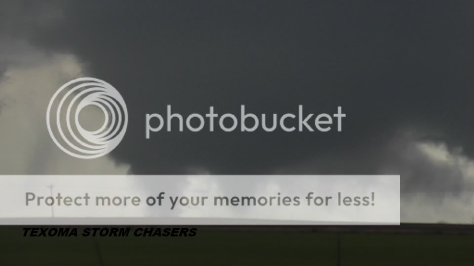
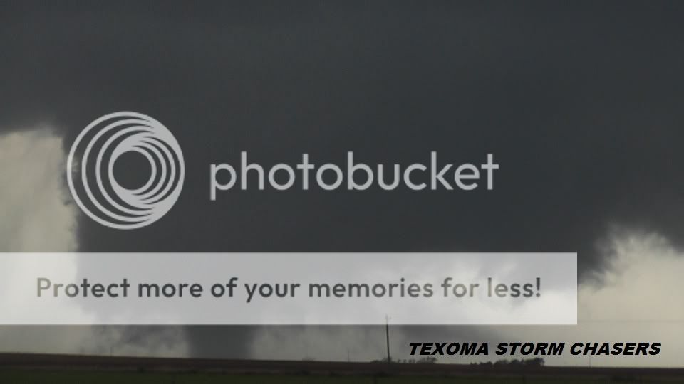
Manitou-Snyder, OK and Wichita Mountains N.W.R., OK tornadoes

NOTE: Here is the message I tried to post on Wednesday 11/9. Thanks to the ST moderators for providing me permission to post in the Target Area forum!

Record setting (for OK!) 5.6 magnitude earthquake struck about 40 miles northeast of Norman at 10:53 pm (0353Z) Saturday night (11/5). I was sitting in the living room watching TV when it struck. Shook the whole house with creaking and groaning. The dining room chandelier swaying back and forth. This earthquake felt even stronger (to me) than the one which struck much closer (on the east side of Norman) in Oct 2010. We had a 4.7 fore-shock at 2 am Friday night but I slept through that one. We had a minor aftershock on Monday evening before the SQUALL LINE hit. Someone under the squall line in OKC called TWC to report a "thunder quake." Yet another aftershock at 1905Z today, but we didn't feel it. Actually, lots of little aftershocks, but I haven't felt most of them.

I just finished a damage survery with Greg Stumpf (NWS/NSSL) and Chris Spannagle (NWS/WDTB). Last evening's (Nov 7th) squall line produced a quasi-linear convective system (QLCS) tornado which caused EF-1 roof damage a house northeast of Blanchard about 1/3rd mile south of the OK 9/US 62 intersection. It died as it crossed the Canadian River on the sw edge of Norman.

Another EF-1 tornado (or RFD?) caused extensive hangar damage at Max Westheimer Airport in Norman...lots of hangar doors blown in/out. It was a narrow path and we found evident of a cyclonic circulation despite the fast movement (40 kt) diminishing the wind on the northwest side of the track. We shall see if WFO Norman decides to call it a tornado. The circulation itself was probably only EF-0 in intensity, but add the 40kt translation speed and you get EF-1 wind damage on the southeast side of the track. It produced EF-0 tree and shingle damage towards NE 12th avenue north of Rock Creek Rd.

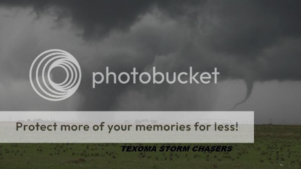
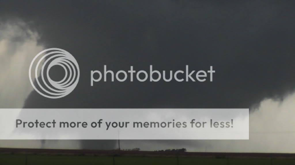
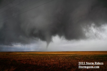
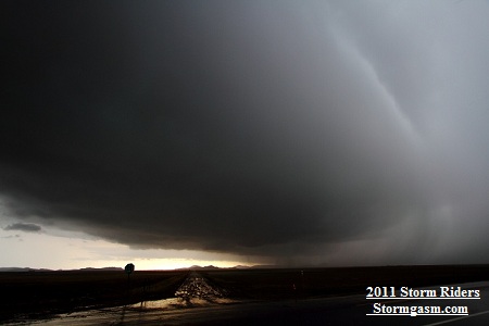
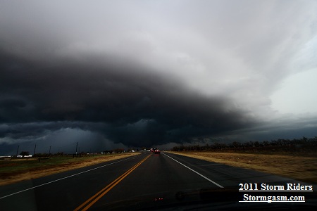
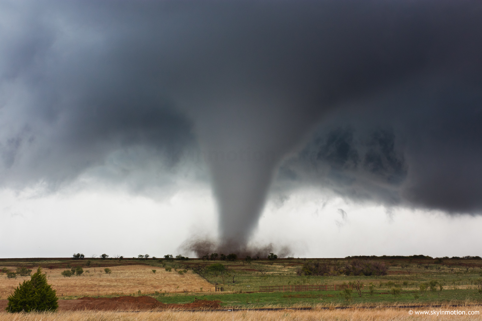
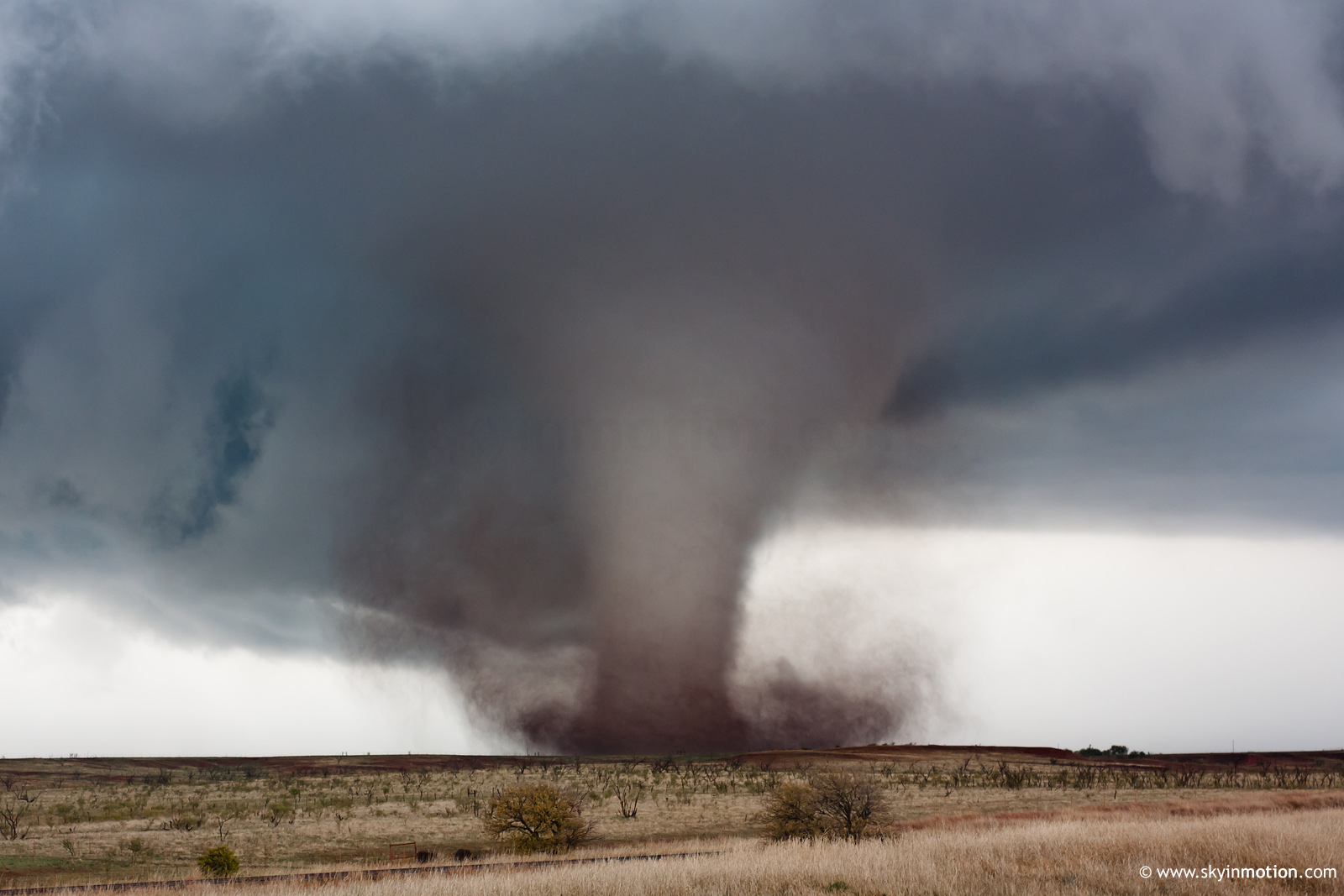
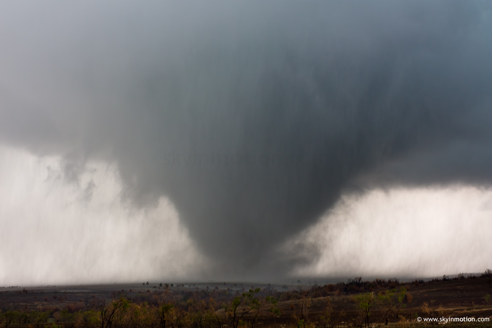
Oh, and by the way, I had one of my best ever storm chases yesterday afternoon Nov 7). A long-track tornadic supercell tracked from Vernon,TX (at 20z) to Hinton, OK (at 00Z). It produced at least six (probably at least 7) confirmed tornadoes including some large, long-lasting, long-track, visually spectacular ones with roars. We missed seeing tornado #1 since our original target was the Jackson Co. (Duke), OK supercell. We still recovered in time for a spectacular show.

WFO OUN Storm Events 11/7/2011

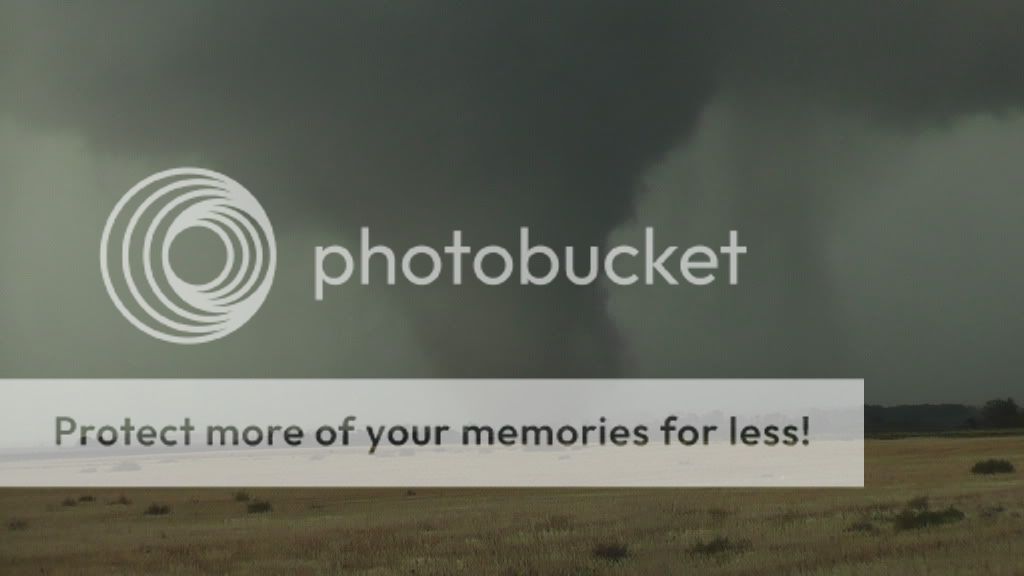
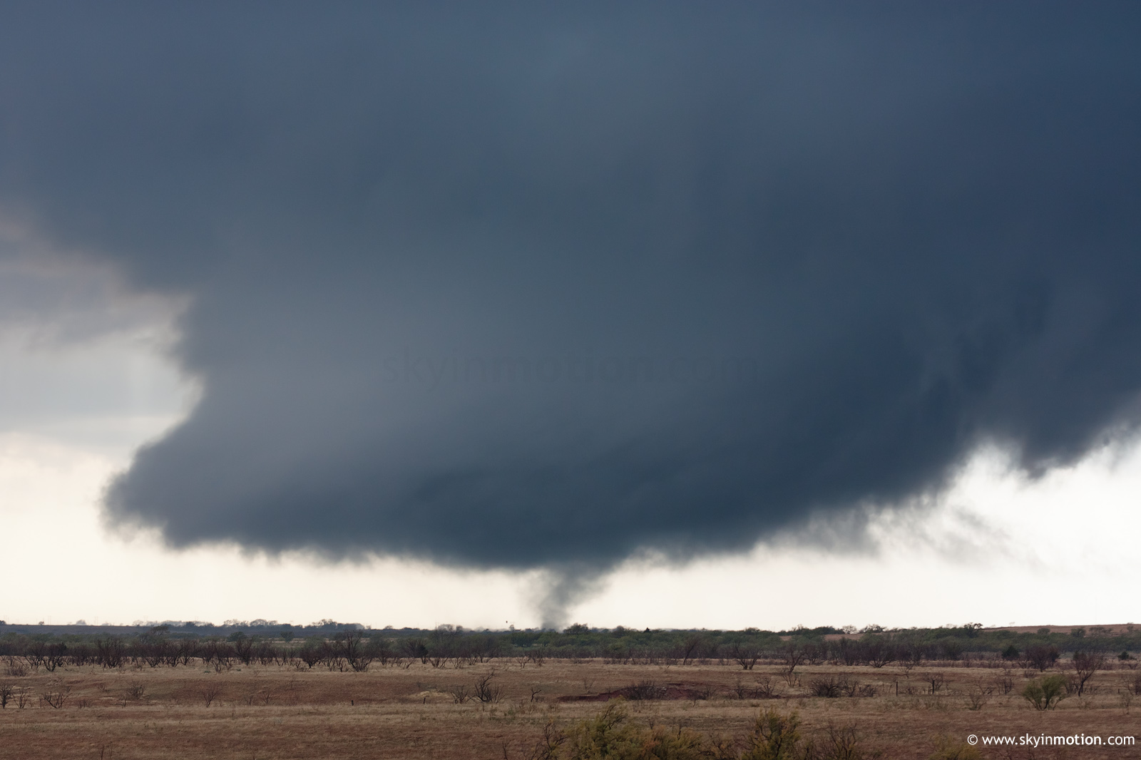
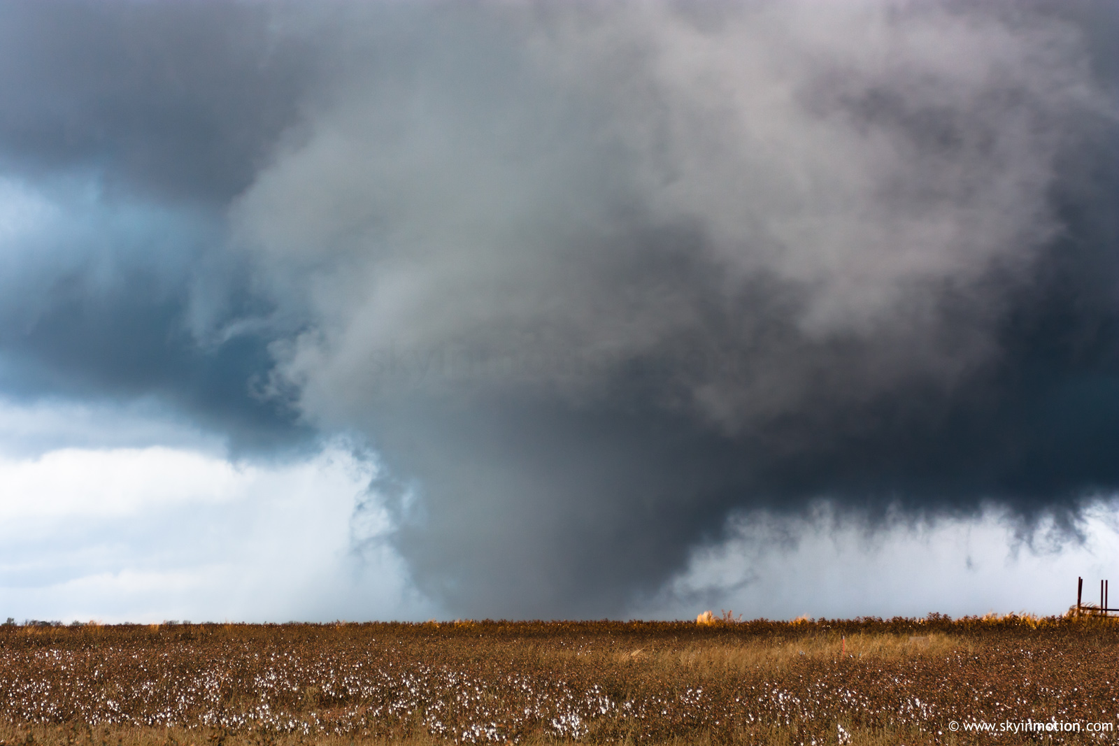
Tornado #2 south of Snyder, OK may be my most visually incredible tornado video ever...with multiple vortices, various shapes and sizes including a Sunray, TX (1971) look-alike cylinder bathed in reddish dust and a "snake-in-a-can." I shot tripoded video from wall-cloud to dissipation and a handfull of digital pics. Chris shot 900+ high-quality digital pics grand total. Strong EF-2+ tornado I'm sure, but nothing much to hit out there to reveal its true intensity. RDF air was virtually ambient temperature which helped explain why the tornadoes lasted so long.

I rank the Manitou-Snyder clip as my best tornado video in 22+ years of storm chasing because of all the various shapes the tornado took, it's close approach w/roar, and the because the camcorder was on a tripod the entire time. Plus, it produced a small, wispy, cyclonic, satellite vortex very close to us (visible between 9:13-9:17 of the clip).

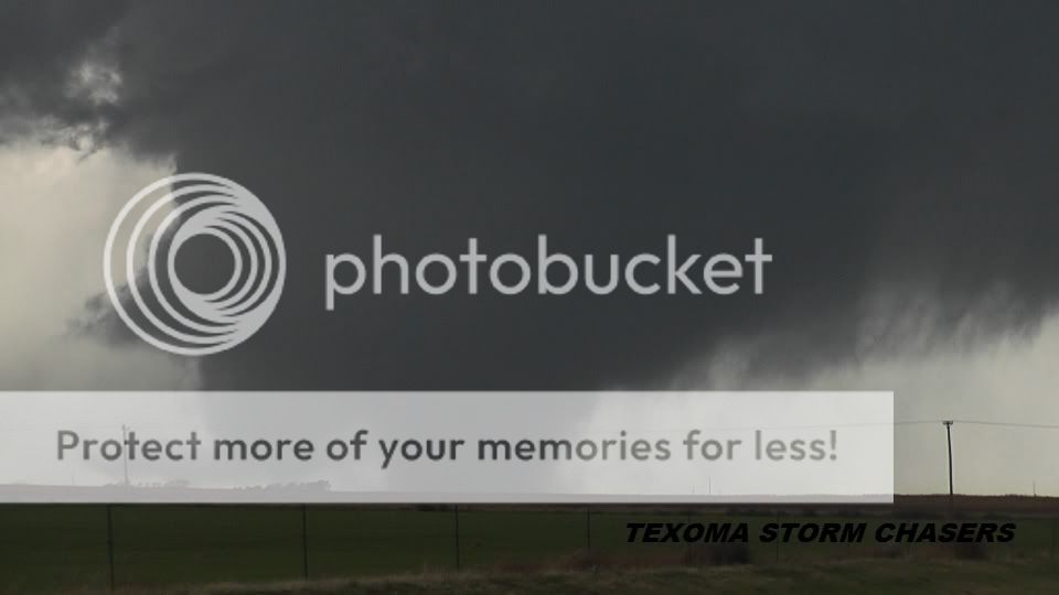
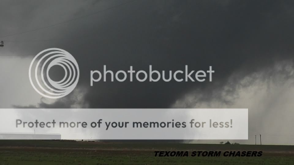
2011 November 7 Manitou-Snyder, Oklahoma Tornado:
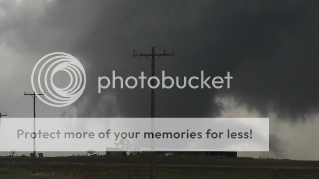
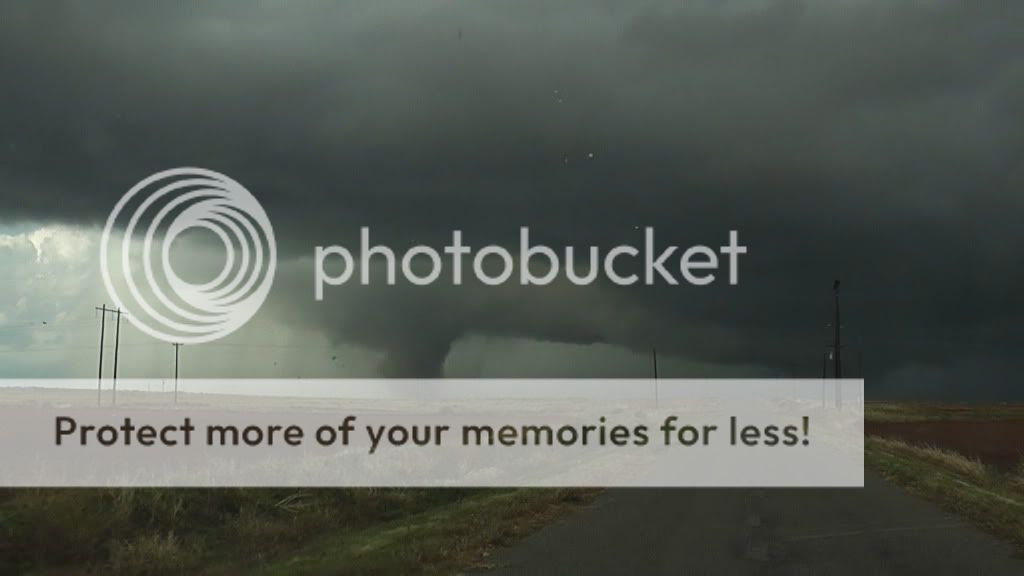
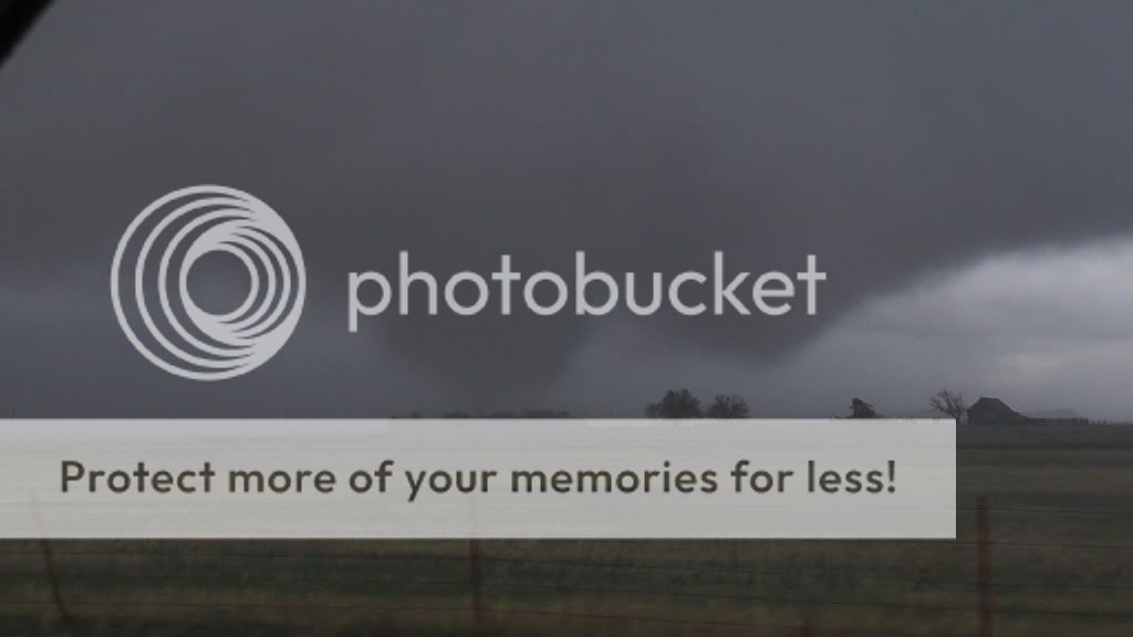
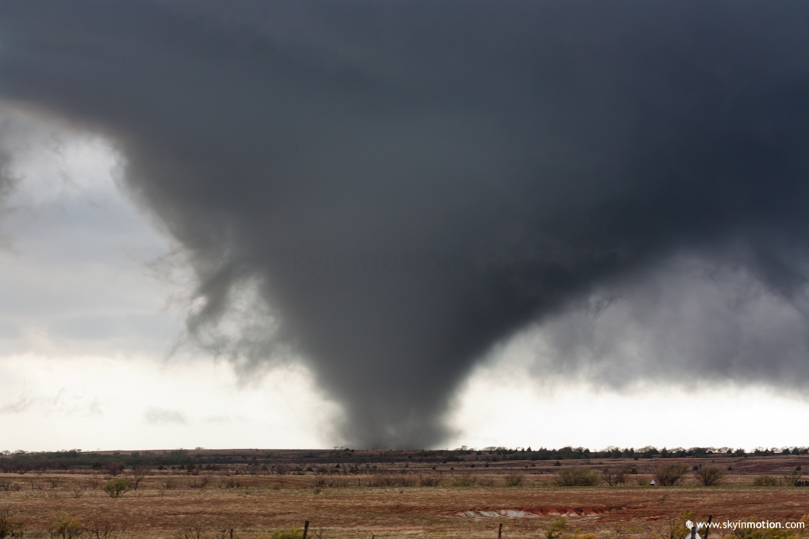
Watch video >

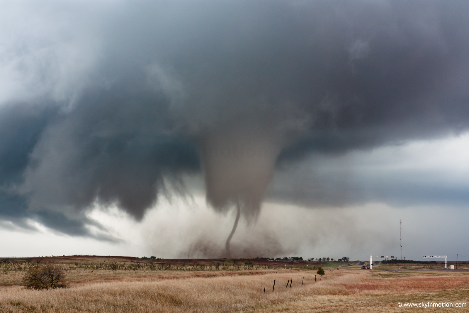
We had to bail east on OK highway 49 out of the path of developing tornado #4 (beat it by 1-2 minutes) just west of the Wichita Mountains. We were parked right on the Kiowa/Comanche County border and had to reposition about 1.3 miles to the east. Got hit with hurricane-force RFD blast that almost took out the powerlines overhead. Tornado passed about 1/2 to 1 mile to our west. Someone in a pickup truck was caught in the outer edges of the circulation a few hundred yards to our west...his front bumper was dragging as he limped eastbound towards us. The tornado crossed the Wichita Mountain tops and passed through a windmill farm. Tremendous roar and a wet hook with large drops. Strong EF-2+ tornado as well, but nothing much to hit out there to reveal its true intensity.

The Wichita Mountains N.W.R. clip is also in my personal top 10 because of its close approach and roar.

2011 November 7 Wichita Mountains N.W.R., Oklahoma Tornado:
Watch video >

Not one, but TWO (2) Oklahoma mesonet stations were hit by tornadoes...Tipton and Ft. Cobb. What are the odds of that?
Mesonet Ticker

Jim Ladue has written an excellent blog entry on the 2011-11-07 tornadic supercell which describes the background synoptic and mesoscale meteorology, the mesocyclone and tornado evolution, and his time lapse video clip of the Tipton tornado lifecycle.

The Oklahoma Mesonet folks have a good page which describes all the incredible events which have occurred in Oklahoma so far in 2011:

http://ticker.mesonet.org/select.php?mo=11&da=09&yr=2011
http://normantranscript.com/headlines/x341227493/Record-breaking-year-tests-residents

Coldest temp
Greatest snowfall
2 blizzards
Largest hailstone (6-inches)
Strongest tornado (EF-5...tie!)
Stongest windspeed (by ground-based instruments...151 mph at El Reno mesonet with EF-5 tornado of 5/24/2011)
Hottest month for a state (in U.S. History!)
Hottest summer
Extreme drought (most of the state)
Strongest Earthquake in Oklahoma history
Strongest tornado for Oklahoma in November (EF-4 at Tipton on 11/7)

The only things we are missing in Oklahoma are volcano and tsunami!
 
Last edited by a moderator:
Matt and I left Amarillo around 11, initially targeting Vernon, TX to start the day. We ended up stopping in Childress for lunch, and caught sight of the first storm to our southwest. We let the storm come to us and watched it as it developed a rotating wall cloud. The storm eventually weakened, and I decided to break us off to the healthier storm to our southeast, approaching Quanah, TX.

We ended up about 5 miles WSW of Quanah, watching the storm base develop a rapidly rotating wall cloud. The storm didn't do much, but I could tell it was just redeveloping to the our north. We drove through Quanah and headed north over the red river. We stopped on HWY 6 SW of Eldorado, OK to watch the storm to our west. The storm cranked up again, showing strong rotation, and had a rather impressive RFD cut come around. The storm got very close to tornadogenesis, but never actually materialized. After driving through an RFD-powered gustnado near Eldorado, we zig-zagged through county roads between Eldorado and Duke. The storm looked ok, but not great. Finally on a main highway, I got a radar update. And my first thought was HOLY CRAP! There was a beastly storm near Frederick. It was time to change our gameplan.

radar.png


Blasting east to Altus, and south down HWY 283, we were treated to a great structure show.

100_6172.jpg


We came over a hill on HWY 5, west of Tipton, when we saw it. Beautiful white stovepipe tornado! It was to our northeast, north of Tipton. We pulled off and watched it rope out. The new wall cloud was to our due east, on the other side of Tipton, it was time to get another intercept.

100_6173.JPG


We were about halfway between Tipton and Manitou, when we saw it to our northeast. A large cone tornado was coming down. We quickly pulled off and watched the tornado morphe to a violent cone tornado. It churned up debris to our north as it looked to impact Snyder head-on. We started to head towards Manitou so we could get closer, but before we got there, the tornado had lifted. We continued towards Snyder. Luckily the tornado lifted before it got to the main highway.

100_6176.JPG


We were about 5 miles south of Snyder on highway 183, when the storm looked to ramp up again. We pulled off and watched a rapidly rotating wall cloud drop vortices under it. Tornado #3 for the day. And the rotation was insane not only in this wall cloud, but behind it towards Snyder. I'm not so sure there wasn't another big one on the ground out that way. We made the mistake of taking a road I saw many other chasers turning down to head east. Turns out this was a bad, muddy road. In our little car, it was bad news. We slowly made our way down this road and tried to get north back on pavement. During this time I was able to catch a large cone tornado to our north through the trees. We finally met pavement on HWY 62. We proceeded to drive east watching a huge wall cloud to our north.

We didn't have to go far before another tornado touched down out of the wall cloud. We pulled over to watch the tornado develop to our north. It was indeed a wedge/large multi-vortex tornado. Unfortunately we were running low on gas, and the storm was moving into bad territory. Road options were scarce in that area. We decided to get on top of a hill and watch the tornado develop about 3 miles away. The tornado was a large multi-vortex tornado at first, then it was just a huge cone tornado. It churned for about 15 minutes in front of us, before disappearing in the rain.

100_6182.JPG

100_6183.JPG

100_6188.JPG


We loaded the car up, and had to go all the way to Lawton for gas. After getting through town, we decided to try and catch our storm. After all, there were still tornado reports coming out from the storm. We continued north on HWY 281. We got to Apache when the storm dropped the Ft. Cobb tornado. From our vantage, the storm structure was just incredible. The storm finally crossed into stable air where it became a blob of precip. We waited out a small hail core in Hinton, OK. We then hopped on I-40, ate dinner in Clinton, and continued home. Couldn't ask for a better day in November.

Here's my video of the 3 big tornadoes we witnessed.
Watch video >
 
Back
Top