John Farley
Supporter
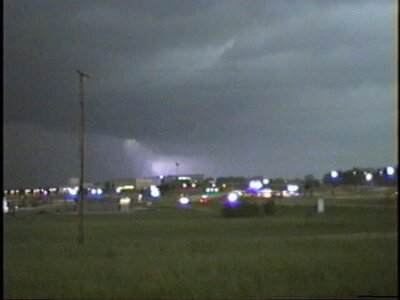
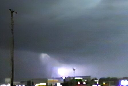
Recently, I have been backing up my old chase report files from 1996-2006 that are on my old web page at SIUE, where I worked back in the day before retiring. I know they will not leave them there forever, so I decided to back up all of them while I still can. The pictures are very characteristic of that era, and the camera technology I had was far from state of the art, even way back then. But in the course of that backup process, I re-discovered an old, poor-quality video capture that had intrigued me a lot at the time, and decided to try to fix it up with today's photo editing technology. The picture is of a feature in an intense HP supercell, looking west from Union, MO. Although no tornadoes (but lots of golfball to baseball hail) were reported near where this feature was, I was always intrigued by its appearance. Below are the original video capture and a version of it enhanced using multiple iterations of Topaz Photo AI and Photoshop. Just de-noising, sharpening, and contrast enhancement, no addition of anything that was not there. Here is the original video capture:

This was captured by going frame-by-frame and grabbing one where there was a flash of lightning. Intriguing, but hard to see what was going on. (BTW, without the lightning, there was not much visible except murky, rain-wrapped darkness. After the aforementioned work with Topaz and Photoshop, this is what I was able to get:

With this enhancement of the picture, it sure looks like there is a tornado there. And it is exactly where you would expect one to be in an HP supercell like this one. However, none was reported there, although it would have been in a somewhat thinly populated area.. A half hour or so after this, when I had retreated east, one was reported about the same distance east of Union as this would have been to the west. Now probably nobody but me cares whether this was or was not a tornado, but I decided to post this because:
1. It is an interesting example of HP supercell structure, showing what at least looks like it could have been a tornado right where you would expect it to be, and
2. It is a nice example of what you can do now with old, crappy storm pictures using the photo editing and AI technology that is available today.

This was captured by going frame-by-frame and grabbing one where there was a flash of lightning. Intriguing, but hard to see what was going on. (BTW, without the lightning, there was not much visible except murky, rain-wrapped darkness. After the aforementioned work with Topaz and Photoshop, this is what I was able to get:

With this enhancement of the picture, it sure looks like there is a tornado there. And it is exactly where you would expect one to be in an HP supercell like this one. However, none was reported there, although it would have been in a somewhat thinly populated area.. A half hour or so after this, when I had retreated east, one was reported about the same distance east of Union as this would have been to the west. Now probably nobody but me cares whether this was or was not a tornado, but I decided to post this because:
1. It is an interesting example of HP supercell structure, showing what at least looks like it could have been a tornado right where you would expect it to be, and
2. It is a nice example of what you can do now with old, crappy storm pictures using the photo editing and AI technology that is available today.
