Mike Umscheid
EF4
An awesome gentleman's chase south of Dodge City, KS this afternoon... provided me my first tornadoes of 2006, lol. I left DDC around 2pm after waking up at 1pm to a situation with the front being farther north than I had thought it would be. I noticed an east to west oriented cloud roll on the 1km VIS in northern Meade to Clark County early in the afternoon and I set my sights on that area. After favoring south...then east aways, I backtracked to Minneola and had my eyes on a very well developed updraft base to my west.. which was rather elongated. The first tornado I saw was a brief translucent "landspout" type tornado on the flanking line near the Meade-Gray county line southeast of Montezuma looking to my southwest. I was still watching the area to my northwest with more interest, however cloud bases were much lower thanks to being north of the boundary. About 10 mins later, another larger dusty tornado was visible to my south-southeast along the flank.
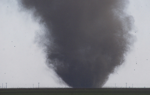
The flanking area seemed to be where the action was, so I headed back south. As I went south, now an even larger dusty tornado was occuring (I think #4 at this point, I don't really remember). and moving towards me. This big dusty column reminded me a bit of Roger Hill's awesome dusty tornado from the Brown County, SD supercell in 2002. It was really churning at ground level. It eventually dissipated only to be followed by another in the distance to my southeast. At this point, I had lost track, to be honest with you.. oh yeah, I almost drove underneath one circulation that was only visible by the floating tumbleweeds rotating cyclonically like right in front of me in a field. At this point, I'm on the county line of Ford and and Clark, about 4 miles northwest of Minneola. I honestly didn't know which direction to focus on because there was vorticity in just about all quads... which also meant something could spin up right in front of me. i then look back to the northwest again towards the parent storm and notice a wonderful occluded tornado cyclone/tornado. I saw at least 3 of these severely occluded tornado cyclone/tornado hybrids... likely F0 cyclonic circulations underneath them, so then I guess you could call them tornadoes... they were certainly cone-shaped large funnels/tornado cyclones.
I get to US 283 at the county line of Ford-Clark about 3 N Minneola and yet another bonafide tornadic circulation is kicking up very dark dust... very tight circulation...with a condensation funnel above it about 1/4 of the way to the surface. The condensation funnel never reached the surface, but it didn't matter to me... it was a beautiful sight with the dark debris cloud beneath it. This tornado was to my southwest moving towards me and US283. I did shoot some telephoto shots of the debris cloud, and they turned out pretty good with some careful processing... there was harsh backlight. The tornado crossed 283 right in front of me to the south about 1/3 mile away, but it was fairly weak at this point...however enough to loft tumbleweeds several hundred feet into the air. I photographed this ground action right as it crossed the highway...with a sherrif on the opposite side of the tornado watching the same thing. This tornado was meeting its demise after passing the highway. To my north, however, at this same time, one of those large tornado cyclones was crossing 283. I could never confirm condensation to the surface, but it was darn close... more than likely damaging circulation beneath it... probably 3 miles to my north.
I then take a breath, head into Minneola and drive east-northeast on US-54 to stay with the storm. As I do this, I could see yet another big dusty tornado in the distance...cloud bases were so low that it was tough to discern much structure to these dusty tornadoes when they are more than 4 miles away. After about 1 mile drive east of Minneola, I see another tornado to my north while driving...this one is a full condensation funnel trunk, but somewhat low contrast and being 4 miles away at least with the cloud bases so low... I could not see a whole lot of the tornado. The last tornado cyclone occlusion I photographed (of the ~3 of these types that I saw) was about 3 miles northwest of Bloom looking to the west-northwest. So, all in all, I don't know how many tornadoes I saw, but I photographed probably 7 or so unique tornadic circulations for the whole chase... with at least 3 that went un-photographed... so 10? A cold-core setup gone mad!
Mike U...whew

 I was not overly enthused by his split decision... and moments later, looking at his Barrons radar; we were squarely in the middle of the meso marker east of Oxford in eastern Sumner Co.....no need for a cup of coffee at that moment... thankfully, we only encountered brief heavy rain and occasional pea sized hail... so then I peeled my fingers off from whatever I could hold on to and knew we were in the clear.


