06/03/05 REPORTS: Plains

Status
Not open for further replies.
Joined
Dec 8, 2003
Messages
2,208
Location
Kansas City, Missouri
Who knows ... this could end up being the only report I'll have today, so I'd better go ahead and post it ... I know it's early but I was up before sunrise to catch this squall line coming through northeastern Kansas. Hadn't gotten any decent lightning pics yet this year, so when I saw this coming in on radar I knew it would be a nice opportunity. Storm had a nice, layered shelf and beautiful colors. Enjoyed myself, even though I'm pretty tired now. Looking forward to seeing if the day will have more in store for us!

0603Lightning0001a_filteredb.jpg


z0603Light0019_filtered.jpg


z0603Light0036_filtered.jpg


z0603Light0009.jpg


z0603Light0094.jpg
z0603Light0095.jpg
 
Great pictures above Mike! My wife said when she left for work this morning we already had 1.30" of rain, and it rained all morning so I'll be interested to hear the total for the day.

I'm sitting in Ness City still, hanging out at the reunion. I was chatting it up with classmates and the sirens went off!! I was thinking we'd see initiation about 2 or 3pm so I wasn't paying much attention.

We had a brief touchdown SW of town (where I wasn't!!). My uncle failed to get pictures of course as he was about four miles away. We got out of town just as the storm past by on the outskirts.

Got a couple of brief funnels dancing up and down, but things quickly diminished after that. I'm going to be sulking all day about the one that got away......not really :) Sooooo it goes.

Tim
 
We had a decent gustfront roll through the Pittsburg, Kansas area, at approximately 3:30 PM CDT. Not much in the way of severe, as of yet. I started the day out by going to Chanute, Kansas. Checked data at the Chanute Airport, and decided I would start making my way towards home in Pittsburg, Kansas. I ran into some really heavy rain and gusty winds around US 169 and US 400 highways. On my way home, I caught up with the pictured gustfront approximately three miles to the west of Pittsburg, Kansas.

Three Miles West Of Pittsburg, Kansas (Looking West)

9014_348.ts1117833467265.jpg
 
Another crap chase day in 2005, but at least today we saw convection. Saw a funnel that just wouldn't go away from the first stuff in Kiowa county, but other than that, it was just another day of driving around, throwing a football, and not having any clue or faith in what would happen. Tomorrow is my last hurrah for the Spring it looks like, as my money is almost gone ($500 extra for busted windshields I wasn't budgeting this year) and the ridge is coming. I'll be able to chase any significant event during the next few weeks, but barring that, my year is pretty much done after tomorrow. I'm going to try like hell to end it on a high note.
 
I finally left Detroit around today at 3:00 AM and arrived in KS around 1:00 PM, and targetted Wichita, since I had no choice (wanted to meet up with Kurt and the gang, but he was thinking TX, and we wouldn't have never made it)...

I got to ICT right in time for that nice squall (SVR-warned), and got some very decent photogenic shots from it, along with strong gusts...

Onto tomorrow, oh and yeah, BACK ON THE PLAINS FOR ME :)
 
Originally posted by Philip Flory

Well, after missing the tornadoes in SW KS and Perryton TX area associated with the low (never planned on staying) I was able to observe a nice storm in N Sumer/S Sedgwick counties this afternoon. I arrived in Wichita at 4pm and ate dinner, upon returning home, noticed on radar a nice isolated storm ahead of the convective line to the SW with an indicated meso. Decided it was ahead of the line for the time being and it was showing some weak rotation, why not? Went down south of my house about 10 miles and observed a couple brief weak wall clouds with some noticable rotation. These quickly dissipated as the line overtook my storm. A little excitement in an otherwise quite lousy day for the C/S plains. Congrats to those who intercepted the tornadoes in SW KS/N TX Pan area!

Moved from 6-4 FCST thread.
 
I pursued the tail-end storm on the line of storms in N. OK and S. KS from southeast of Enid, OK to southeast of Winfield, KS. At times it was backbuilding fast enouth to offset the rapid northward storm motion so I could just sit and watch; at others I could barely keep up, even hauling north on I-35. Only saw one severe report for this storm, though it had several warnings, but the tail end was sufficiently isolated and free of surrounding clouds to be beautifully sunlit and produce several nice rainbows - so it was a very photogenic storm even if it did not produce much in the way of severe.

I first got on the storm near Covington, shortly after it went SVR warned at 4:45. Around that time, it produced 67 mph wind at Vance AFB near Enid, and I could see the shelf cloud off to the NW. It tried to produce some small lowerings under the updraft, and the backbuilding made it quite chaseable for a while even though the reported motion was N at 50.

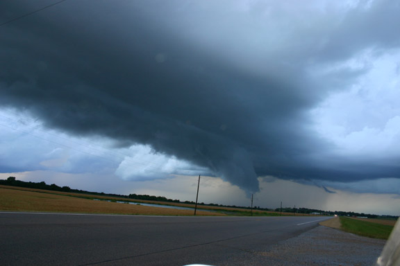
Eventually, though, it got away from me, and I had to blast north on 14 and back east on 412 to I-35. I caught up again around Blackwell, where I cut over on 11 to 77 and followed in N into KS. The updrafts near the tail end strengthened, and it tried to produce an RFD near Newkirk:

Newkirk.jpg


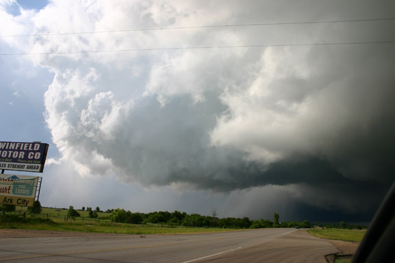
The south end of the line of storms had become very low-based and very isolated from any surrounding clouds, so it was well-lit and photogenic. Here's proof you don't need tornadoes to have a successful chase:

arkcity1.jpg


This pic was taken from just east of Arkansas City, KS.

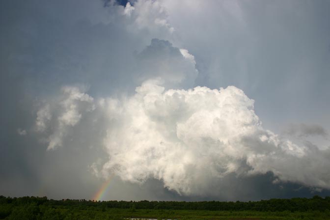
Later, new storms went up west of the line, and though numerous, they were less linear and more individual, as shown by this pic:

Winfield.jpg


This picture was taken near Winfield, KS just before sunset.

The trend of more individual storms continued after dark, as upper winds shifted to the west on the back side of the shortwave, creating better shear. Naturally, after dark and around the time I found a motel in ICT ('twarn't easy, with the Special Olypics in town!), new storms in Cowley Co, KS produced multiple tornadoes. Such is fate in 2005! :evil: In fact, a tornado may have occured around 10 p.m. in almost the exact spot of the Arkansas City above.

Edited 6/5 to add more detail and two new pics.
 
Upper Low tornadoes Friday

A surprise came quickly Friday afternoon as a pronounced dry slot rotated northward into the N.Texas and C. Oklahoma Panhandle between Perryton and Guymon. What was barely a convective shower yielded a small tornado over NE Hansford Co. TX...just as Jeff and David Hoadley were discussing the interesting aspects of dry slot upper low tornadoes. This tornado remained on the ground for approx. 6 minutes as it rotated slowly north-northwestward across NE Hansford Co. The tornado dissipated after kicking up a small debris cloud. The white tornado was very obvious and was widely visible for video from south of Perryton TX. The dry slot allowed for easy viewing from well east of the tornado. The report was called into the Ochiltree Co. Sheriff and the NWS Amarillo where the report was received with some uncertainty. As with upper low dry slot situations, the tornado while small was well developed and with the weak radar returns, can certainly understand some disbelief with this report. A second and third tornado later occurred near the town of Hitchland with the same area of "storms". These tornadoes were also small and lasted a shorter time. Later as this same section of the upper low moved northward up to the west of Garden City KS, additional tornadoes were spotted and tornado warnings were posted for these tornadoes by the NWS Dodge City. All in all, this was an unexpected tornado surprise for what happened very quietly and probably unnoticed by the general public in the N. Texas Panhandle/C. Oklahoma Panhandle.

Report by Brian Stertz....on the chase with Jeff and Kathryn Piotrowski
 
Relayed report from Darin Brunin:

Darin, Doug Mitchell and Andrew Ashley witnessed two, possibly three tornadoes this evening near Hardy, OK. They report that three seperate wall clouds were visible from their vantage point atop a hill southwest of town and that they can confirme a tornado from one wall cloud to their north, one from a wall cloud to their east and the possible third from another wall cloud that was also north of their location.

Regards,

Mike
 
Gorgeous photos Mike! wow. Congrats to those of you who caught the tornadoes today. What a tough day to chase. Here are some photos of the wall clouds and funnel we saw in SW KS in Meade county and north a little.

I better get some sleep for the chase tomorrow. Hope to see some of you out there.

http://www.twistersisters.com/images/06030...ll_cloud_01.jpg
http://www.twistersisters.com/images/06030...ll_cloud_02.jpg
http://www.twistersisters.com/images/06030...ll_cloud_03.jpg
http://www.twistersisters.com/images/06030...5/funnel_01.jpg

Mel
 
Oklahoma's back from the dead! Myself, Doug Mitchell, and Andrew Ashley observed two tornadoes just southwest of Hardy, OK last night.

WOW!.....What a long day and and what an amazing night. Just got back into Lawrence after 20 hours straight on the road. We started off the day in Woodward, OK then got to Childress, TX as soon as possbile. After this we headed east to Wichita Falls hoping that some isolated supercells would develop further south into Texas away from the linear garbage in OK. After checking data in Wichita Falls we waited around for a while and decided that with the poor instability and almost non existent lifting mechanism (the dryline never seemed to set up like expected) we were going to try and get back into E. KS as soon as possible to set up for today. As we headed north from Wichita Falls towards Lawton we noticed that an isolated storm was starting to go up just north of Lawton only about 20 miles to our north. This storm as as others mentioned above just could never get its act together and was racing north at near 40mph. This fast storm motioned caused us to meet up with some of Oklahoma's finest as we were trying to keep up with it. So, one pricey speeding ticket later we decided to call the day a bust and headed towards OKC seeing Dave Crowley and Dan Robinson among others on our way. After stopping for supper at Bennigans we headed north on I-35 and as we neared the KS/OK border we saw some storms going up to our north and after getting closer noticed that they definitely had supercellular characteristics to them. As we approached a storm that was getting ready to cross I-35 in front of us our eyes lit up everytime that the sky did as the storm had amazing structure to it and a very ominous wall cloud that was over I-35. We exited at Ponca City and not to long after a tornado warning was issued for the storm. We stayed a safe distance away from the storm and followed it northeast for a while. Thanks to Matt Jacobs and Dick McGowan for your assistance.

Here is what we saw....

Storm earlier in the day with the picture being taken near near Chickasha
DSCF1570.jpg


These are all vid caps so the quality is not great but they get the job done

Wall cloud crossing I-35 in front of us right over the overpass
IMG_0779.jpg


Amazing structure just a little west of Ponca City
IMG_0788.jpg


East of Ponca City another wall cloud starts to take shape
IMG_0790.jpg


Tornado #1 3 miles southwest of Hardy.
IMG_0776.jpg


Tornado #2 to the southeast of tornado one . Both of these tornadoes were on the ground at the same time so I was jumping back and forth trying to get them both. This tornado definately had ground circulation with it although it does not show up well in this picture.

IMG_0797.jpg
 
Maybe this should be a 6-4 post since it was after midnight.

Anyway here is a couple quick pics from vid. between Sedan and Independance ,Kansas.
After setting at home watching 3 torn. warnings within an hour or so from me ,I couldn't stay home any longer and headed to Kansas.

kansas64050660006.jpg
This one was being reported on the ground when this was taken

kansascone.jpg
cone left/west of bolt , west of 75

060405ksrope.jpg

Rope near Independance. My location should be just west of Independance lookin east, Reminds me of the Mulvane 6/12/04
 
Short, short version of a report, more photos and details to come.

After cap-busting in Lawton, Bill, Matt and I headed north for lightning photos from storms that developed in northern Oklahoma northwest of Bartlesville. We ended up seeing our storm morph into a monster supercell with frequent lightning, a persistent wall cloud and several funnels. We followed the storm to Independence, but did not see the reported rope tornado.

Video Captures:
june3a.jpg


june3b.jpg


june3c.jpg


Digital Photos by Matt Robinson - click to enlarge


We called it a night after 3AM and spent the night in Bartlesville. Getting ready for a hopefully big day today.
 
Awesome day and night.

Start out about 5:00 right after work and watched a cell form up over Blackwell, OK. (This was the same series that John Farley has such a nice photo of). Lots of motion with this line. At times the clouds weren't 500 feet overhead. I continued to follow this from south of Blackwell to east of Arkansas City crossing several times under the flow. Had to leave this as I had to be in Enid for some filming.

Later (after the filming and rushing back home) picked up on a cell that was getting seriously wound up north of Lamont. This cell would later move into northern Osage County and produce the tornado in the Hardesty area. I tried following it, but it was a mover and I made a couple of bad picks for roads. It got out ahead of me and I lost track of where the core was. Rather than fumble about like a blind man in a new room, I decided to bring it back. Did experience a couple of head on wind gusts in the Newkirk area, one of them strong enough to break the cups on my Davis Anemometer. This was due to combined driving speed and head on winds. I figure combined were about 130 mph.

Even later, watched another small cell get organized on I-35 between Blackell and Tonkawa. This cell was SVR warned north of Ponca and then scooted into Kansas at a heft 40 to 45 mph. Called it a night at that point.
 
Status
Not open for further replies.
Back
Top