State of the Chase Season 2023

Status
Not open for further replies.
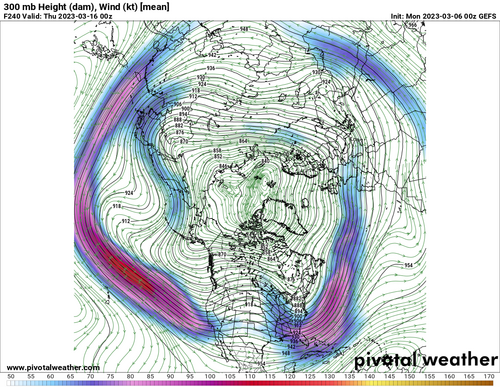
Starting to see a strong signal for a large east Pac westerly jet extension developing over the next 7-14 Days. That large-scale jet energy should translate into western US troughing through mid March and posisbly into early April. The ensembles and climate mdoels continue to weaken the eastern US troughing and cold air intrusion which should keep the Gulf free. Water temperature anomalies are also elevated and should continue to rise as we get mroe sun. I think an active severe pattern is liekly to develop in the next few weeks. This could be one of the bigger bouts of the season if we get the jet energy and favorable return flow.
1678235418177.png
 
Are we allowed to discuss chase vacation plans here?

For the first time, I have a fully remote job, and can spend more than a lousy two weeks on the Plains… I still have limited vacation time though. So the idea would be, instead of taking 10 vacation days for a two week trip and chasing every marginal risk, spend 3 or 4 weeks on the Plains and spread those same 10 vacation days over that period, saving them for the better events and blowing off the crumbs.

Potential problems with this idea:
- If chase partners can only come for two weeks, they are going to want to maximize every opportunity. So I may end up using all my vacation time going after crap anyway, leaving no vacation time for the better days outside of the time my chase partners are with me.
- Repositioning days end up burning more vacation time than anticipated.

Possible solution: Stay on the Plains for 3 or 4 weeks, do a hard core 2-week period with my chase partners, and in the remaining time hope for (a) stuff on the weekends, and (b) use the evenings to position so that the next day I can work all day and still get to a “local” target.

Thoughts?
I like option two James. That’d let you maximize your quality chase days. You can’t chase if you’re not there. I’d bet there’d be a number of days where you could work half a day and then chase, especially if you had a repeating dryline.
 
I suspect the cause of the early season activity is related to the sudden stratospheric warming (SSW) event we just went through. We're in the late phases of this event, which takes several weeks to process, and it appears the stratospheric polar vortex (SPV) is effectively "rebooting," which suggests the active pattern will taper off within the next few weeks.

That's really all I can glean from what's currently happening. I'm not particularly knowledgable on S2S (sub-seasonal to seasonal) forecasting, and I'm not aware of any reliable methods of predicting overall activity more than a few weeks in advance right now...at least as far as the upper-air Rossby wave pattern is concerned, as that seems to be a top-two driver of overall activity. After all, it is hard to get widespread or predictable severe weather without synoptic scale forcing, even if a great mT airmass is in place!

I've seen others comment on some other factors that can be used to assess the potential for a good year. The big one to me is precipitation and soil moisture anomalies in the EML source region (SW US and N Mexico). While California and Nevada (and parts of Arizona) have been deluged this winter, those areas aren't really in the EML source region. So we have to look further to the southeast. I like the NASA SPORT Land-Data Assimiliation System website for analyzing this group of factors (Real-time 3km Land Information System over CONUS). The current relative soil moisture in the top 10 cm of soil is below:
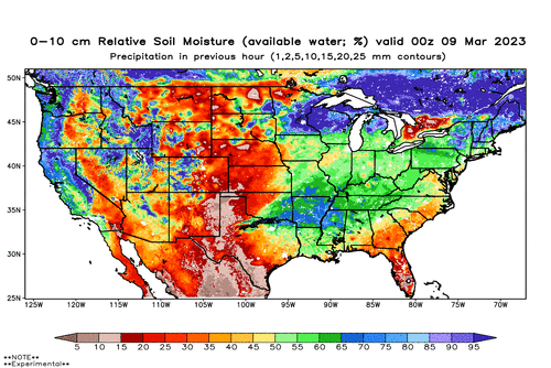
rsoim0-10_20230309_00z_conus.gif

The value of the field is the fraction of available soil moisture that is realized (0% is totally dry soil, 100% is completely saturated soil). This is averaged over the 10 cm depth nearest the ground surface, where moisture access is most immediate. Soil temperature and moisture do have a memory, and the memory is longer in deeper layers since it takes a long time for water and heat to propagate upward towards the surface. Sensible heat flux generally only occurs right at the ground surface (referred to as the "skin" layer, and if you see "skin temperature" it is referring to the temperature right at the ground surface that IR satellite products measure when you look at IR satellite). Latent heat flux can occur directly from the soil surface, but also from plant evapotranspiration. But since most plants have fairly shallow roots, then the uppermost soil moisture will generally provide the highest correlation with potential latent heat flux. So if you're looking for more immediate impacts of soil heat and moisture transfer to the atmosphere, you want to look at the near-surface soil. But the deeper stuff can give you a sense of how "resilient" the upper soil layers will be to a period of high heat and no rain, for example.

Okay, so that's it for the primer on land-atmosphere exchange processes.

What I see is that it is quite dry across the EML source region, this is not necessarily atypical for this time of year. If we look at the soil moisture percentiles instead, we can see if this state is anomalous at all.
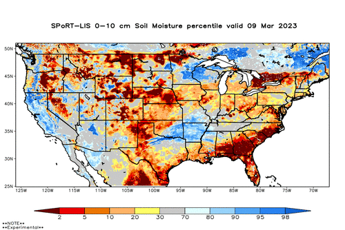
vsm0-10percent_20230309_00z_conus.gif

In areas of E NM, W TX, and NE Mexico, it is indeed pretty anomalous. But further west (AZ, NW Mexico) the current soil moisture is anomalously wet. So...a bit of a mixed signal right now. It doesn't help that the recent precipitation anomaly is correlated a lot with this.
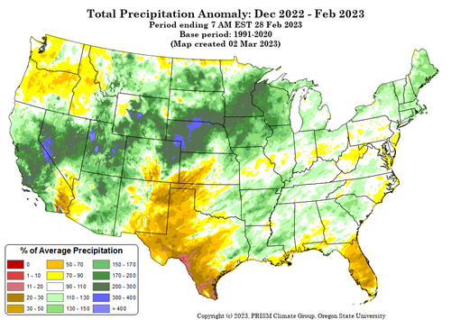
PRISM_ppt_provisional_4kmM3_anomaly_202212_202302.png

I'd be more excited if that big precip anomaly on the central high Plains was displaced further south. But this signal could bode well for the later season activity further north.

One other resource I like to use (a bit shorter time scale) is Victor Gensini's dynamical SCP statistics forecast from the GEFS forecasts here: Extended Range Severe Weather Environment Forecasts. You only get about a 2-week lead window on this.

Don't forget about MJO either (CPC - Climate Weather Linkage: Madden - Julian Oscillation).
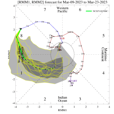
ensplume_small.gif
The GEFS is actually predicting a massive swing through the phase-8-1-2 range, which is the optimal phase range for active troughiness and storminess in the central US. It doesn't guarantee a stormy pattern, but it sets the stage. We'll see how the next week or two goes as this phase transition occurs and see if an active period accompanies it.

More as it develops.
 
Wanted to throw this in for some of the newer members as I learned a fair amount... those more experienced can probably skip it. I appreciated the effort, and I hope sharing it here is ok.
Teleconnections was something I had put on the back burner to study at a later date, and I thought this was a good primer.


As a summary, this gentleman finds previous years analogous to the current trends based on ENSO, DCO, and EML source region drought. His conclusions lead to an average amount of tornadoes overall for the year, with a very active March and April, and below average 2nd half of the season.

I understand most of this is wishcasting, but I enjoy reading into the different patterns and learning from all the various posters in these long range forecasting threads.
 
As I posted in the comments to Trey's video, it's interesting that he finds mostly favorable indicators regarding teleconnections and Gulf SSTAs (EML source region drought is present, but not as bad as it's been in some reason years), yet the analog years he found were mostly lousy to mediocre at best chase seasons.

I think the late winter SSWE is a big wild card, like @Jeff Duda mentioned above. If it behaves just like 2018, we're screwed. However, the EML region drought was more pronounced at this stage that year, and at this point it's looking like the cold air surges into the Great Lakes/East won't be quite as potent as they were that year, and that the Gulf might be shielded from the constant CP air intrusions through the third week of April like that year.
 
Andy my historical knowledge of how SSWE's enhanced or minimized tornadic years is minimal. Is there a historical trend or some data to go through that shows correlations of SSWE's tying directly or indirectly to tornadic years?
 
Andy my historical knowledge of how SSWE's enhanced or minimized tornadic years is minimal. Is there a historical trend or some data to go through that shows correlations of SSWE's tying directly or indirectly to tornadic years?

I'm not particularly knowledgeable about it myself. I think it's highly dependent on where the resulting trough sets up. In years like 2014, 2018 it allows for a trough to set up over Hudson Bay and just park there for most of the spring, dumping cold air into the Midwest and hindering moisture return as well as messing up the ejection of any troughs that do try to come into the west.
 
interesting. I forget if 2014 was a neutral or La Nina year, but it seems like given a notional trajectory of moisture and ridge to trough setups during those La Nina years that a SSWE would enhance the trough condition present in one region? or only neutralize it?, but I am not afraid to say I don't exactly know how those Rossby wave, SSWE, and ENSO relationships interact intimately. I need to see an animation of all of the systems at work at once. I tend to learn it better that way. So if someone can create a multi layered product of the globe showing all of these teleconnections and interactions, "that would be greeaaaaat" - office space.
 
Last edited:
For what it's worth, the CFS is liking the second week in April.

Jeff's detailed discussion on soil moisture is much appreciated and something I watch for both spring tornado chasing and during the monsoon for dust storm potential. "Soil moisture content" was a common discussion going back to my early chasing days -- noted by many "old timers" in E-NM and W-TX with tornado activity (+/-).
 

Attachments

  • cfs_bchiclet.png
    cfs_bchiclet.png
    287.9 KB · Views: 0
Last edited:
It's interesting that the SSW was mentioned as I did wonder too. In Europe it can bring in cold northerly or easterly winds because the Atlantic jetstream gets disrupted in its flow, which might also then have had an effect on the cold weather in the USA.
 
Latest CPC seasonal drought prediction. Appears to be some fairly good news for portions of the central and northern plains.
 

Attachments

  • season_drought.png
    season_drought.png
    103.7 KB · Views: 0
https://www.weather.gov/media/abq/Briefings/2023SpringOutlook.pdf

While not specifically about severe weather this is a presentation from NWS ABQ with their expectations for the spring in New Mexico. Possibly some improvement in the drought conditions. Below is a copy/paste of the last page of the presentation with their expectations for this spring.

March: Forecast confidence is high for above average precipitation and near to slightly
below average temperatures

April: Forecast confidence is moderate for average to slightly above average
precipitation and slightly above average temperatures

May: Forecast confidence is moderate for near average precipitation and slightly above
to above average temperatures

Severe Weather: Confidence is moderate to high severe thunderstorm activity will be
near average, and well above last year’s amount
 
Last edited:
Just as an aside, It's great to see all the discussion on this board for the season so far. Thanks to everybody who has chimed in or stopped to read through things!

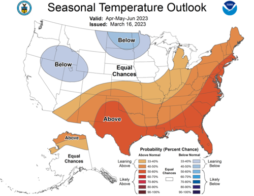
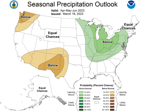
Heres a quick update from CPC on their spring forecast.
1679093344516.png
1679093355864.png

Honestly, I cant find much to complain about as a chaser for this general pattern. There remains hints of western and central US troughing through April and May on the ensemble climate models. CPC seems to be betting on that signal with much cooler anomalies noted over the PAC NW and western CONUS where California has been getting slammed. We remain above average on tornado counts early this year despite March slowing down a bit. However, the next few weeks show several potential systems. We only need 1 or 2 more decent tornado days to finish March at or above average.
 
Last edited:
That MJO pulse I described in my previous post appears to be collapsing as it evolves through phase 1, so perhaps nothing will end up coming of that.

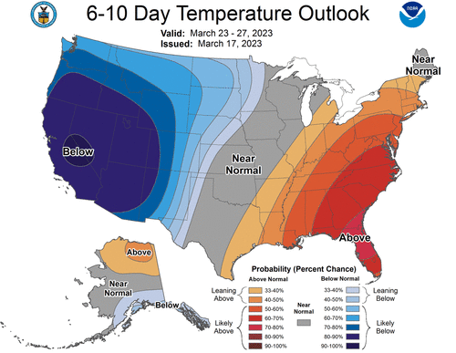
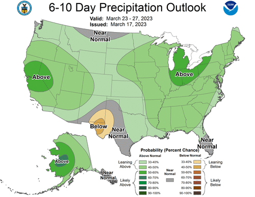
However, the recent temperature and precip outlooks from CPC, which have been really consistent the past month or so, is a bit dreamy for Plains chasing...if it were May. In March, it's probably a tad early.

610temp.new.gif610prcp.new.gif
 
Status
Not open for further replies.
Back
Top