adlyons
EF2
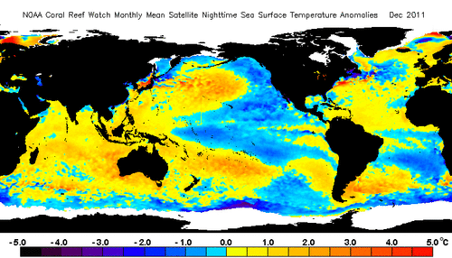
I found an interesting paper by several well-known seasonal tornado researchers that may be relevant to the coming months. Im sure most remember the headlines hyping 2021 as an active year due to La Nina. I can bet ALL of you remember how that turned out  . What interests me this year is that La Nina is already behaving like La Nina whereas last year's event seemed to lack a more traditional response over the CONUS. I recommend an excellent article by Dr. John Allen on this very topic. La Nina 2021 A quick summary, 2021 La Nina failed to show up in the ways we expect and terminated early which may have contributed to a wonky tornado season. For visualization:
2021 vs a typical La Nina pattern 500mb anomalies.
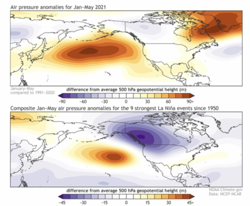
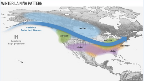
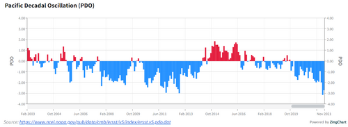
We have regressed back to La Nina for the second time in 2021 and forecasts continue to show a moderate event developing through Winter 21-22. In most respects, this event has already behaved more prototypically with an abundance of cooler and wetter conditions along the West Coast and BC. We have also developed the typical cool anomalies off the coast of Alaska helping to bolster above-average ridging over the Pacific. This ridging is important for westerly jet extensions and eventual trough development. So how does this tie into the paper I linked and possibly have implications for spring 2022?
The paper focused on the role that ENSO state and Gulf of Mexico SST anomalies have on wintertime (DJF) tornadoes in the CONUS. To quickly summarize the findings;
So let's compare these conclusions to some current data.
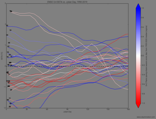
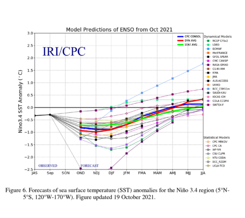
Starting with ENSO State, we are currently under a La Nina advisory with strengthening towards moderate conditions through the coming months. We know things are more or less behaving as expected atmospherically speaking. The research mentioned above suggests that tornado potential in the SE is increased when typically La Nina conditions are present.
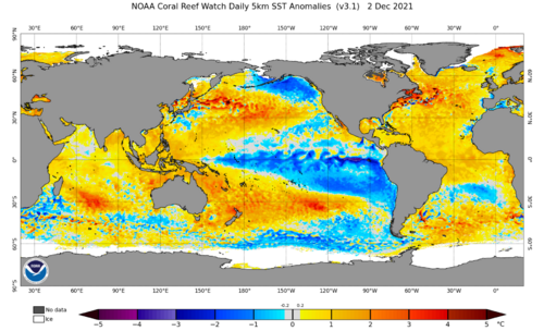
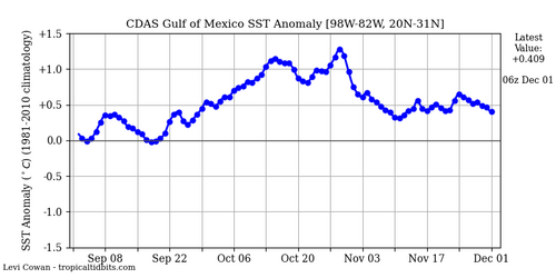
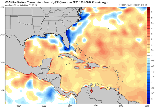
SSTs The GOM is warm, with average anomalies on the order of +0.5C. This again hints at some potential in the coming months that the 2022 season could start faster.
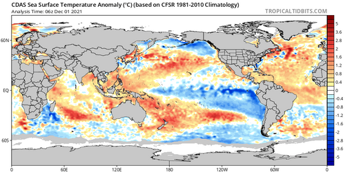
Something else to point out with the SSTs is the cool bubble in the ePAC. This is again expected with La Nina and shows up quite nicely on the current anomalies. It is also a contributor to more significant tornado activity across the CONUS.
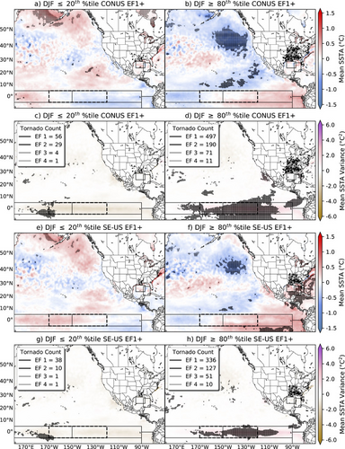
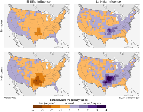
So what does this mean? Well not a whole lot if 2021 shakes out again. However, if La Nina conditions persist and behave accordingly, the warm Gulf and expected weather pattern resulting from La Nina may contribute to a faster start to the 2022 tornado season and a mnore active witner across the SE US. There may also be some implications for spring 2022. La Nina patterns favor the southern Plains and Midwest.
While fast starts are not always indicators of future performance, it never hurts to get on the board early as opposed to playing catchup with the averages. Most of the years that do start fast hang around average longer or finish above average as opposed to slow seasons.
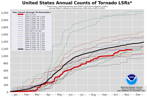
What do you think 2022 holds given the current patterns? Ill be verifying my 2021 forecast and issuing a full 2022 season forecast here in the coming weeks as we wrap up the year.
2021 vs a typical La Nina pattern 500mb anomalies.


We have regressed back to La Nina for the second time in 2021 and forecasts continue to show a moderate event developing through Winter 21-22. In most respects, this event has already behaved more prototypically with an abundance of cooler and wetter conditions along the West Coast and BC. We have also developed the typical cool anomalies off the coast of Alaska helping to bolster above-average ridging over the Pacific. This ridging is important for westerly jet extensions and eventual trough development. So how does this tie into the paper I linked and possibly have implications for spring 2022?
The paper focused on the role that ENSO state and Gulf of Mexico SST anomalies have on wintertime (DJF) tornadoes in the CONUS. To quickly summarize the findings;
- EF1+ Tornadoes are more common in La Nina and El Nino than in neutral conditions and significant tornadoes make up a larger fraction of tornadoes in DJF.
- Gulf of Mexico SST anomalies independently contributes to seasonal variability at least through DJF by modulating surface moisture fluxes and buoyancy.
- SST anomalies in the eastern Pacific are also contributing to the variability and are more readily influenced by ENSO state.
So let's compare these conclusions to some current data.
Starting with ENSO State, we are currently under a La Nina advisory with strengthening towards moderate conditions through the coming months. We know things are more or less behaving as expected atmospherically speaking. The research mentioned above suggests that tornado potential in the SE is increased when typically La Nina conditions are present.

SSTs The GOM is warm, with average anomalies on the order of +0.5C. This again hints at some potential in the coming months that the 2022 season could start faster.


Something else to point out with the SSTs is the cool bubble in the ePAC. This is again expected with La Nina and shows up quite nicely on the current anomalies. It is also a contributor to more significant tornado activity across the CONUS.


So what does this mean? Well not a whole lot if 2021 shakes out again. However, if La Nina conditions persist and behave accordingly, the warm Gulf and expected weather pattern resulting from La Nina may contribute to a faster start to the 2022 tornado season and a mnore active witner across the SE US. There may also be some implications for spring 2022. La Nina patterns favor the southern Plains and Midwest.

While fast starts are not always indicators of future performance, it never hurts to get on the board early as opposed to playing catchup with the averages. Most of the years that do start fast hang around average longer or finish above average as opposed to slow seasons.

What do you think 2022 holds given the current patterns? Ill be verifying my 2021 forecast and issuing a full 2022 season forecast here in the coming weeks as we wrap up the year.

