Incredible -- 3rd Major Tornado Warning Miss This Weekend!!

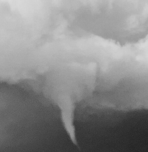
Not to pile on here, but i’ve in the past seen radar couplets with ground verification on storms that weren’t even severe warned. I don’t have screen shots from RadarScope included in the two files below. These files are from this weekend by Prague Nebraska. One is a tight circulation from over my head and the second is a still of the funnel that followed. I didn’t report it because someone else already had done that. It just shows that even if the NWS gets a handle on the bigger tornado events, there’s still a lot of minor ones that sneak through the cracks.
Edit: I had to edit the video clip down to one second. It’s just enough time to see the rotation.
View attachment IMG_1791.mov
IMG_6267.jpeg
 
there’s still a lot of minor ones that sneak through the cracks.
Edit: I had to edit the video clip down to one second. It’s just enough time to see the rotation.

Thanks, Todd.

A quick FYI. None of the events I have documented are EF-0.

You'll also note that, several times on my blog, I have noted that some tornadoes are "unwarnable." In the case of the Baring MO unwarned EF-2 Friday night, the fault is with NWS HQ for turning down a free radar in NE MO rather than STL NWS because the tornado was 133 mi. away from their radar.
 
Both Baring, MO, and Marceline, IL are in my viewing area. I was working Friday night and did the 5, 6, and 10 PM newscasts. This happens more frequently than it should in this radar hole.

Baring is the strongest tornado in the region that went completely unwarned in my recent memory. It is true that a SVR thunderstorm warning with TOR possible tag was issued after the fact, but other than that, there were no warnings. In addition, a SVR thunderstorm watch was in effect earlier to the immediate south but was canceled early at 10 PM. There's merit in taking special attention to environments where MCVs move into a region that has seen even a modicum of daytime instability. I was worried about weak TOR potential but didn't think an EF-2 would occur. The same is true for Marceline, IL in northern Adams County. There was a brief velocity signature noted on SRV but after one or two scans it was gone, and as we discovered, the path length was pretty short. Agreed that LSX was pretty much left with no way to know what was going on given how high the radar is looking in that region and, being nighttime with few spotters, no one likely would have seen it coming.

In addition, another TOR occurred Sunday afternoon east of La Harpe, IL in Hancock County. There was a previous tornado warning for the same storm. I had asked the NWS about extending the warning to La Harpe and points east but the warning was allowed to expire prior to the cell reaching eastern Hancock County. While you can see that the rotation had weakened, the tornado east of La Harpe did occur during an unwarned period whereas the first tornado did occur within a warning and DVN was on the mark with that warning. Of note, however, is that this area, while in a void, is closer to DVN's radar than NE MO is to either EAX or LSX. It's still a symptom of the same problem with less-than-stellar radar coverage in that area too.
Tornado confirmed in Hancock County from Sunday storms
 
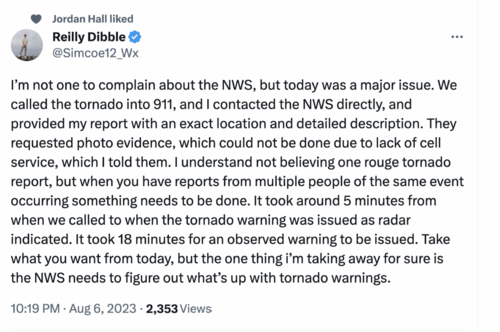
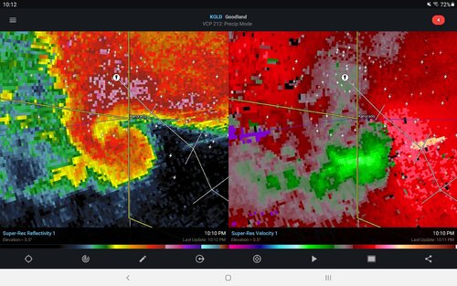
Watch the radar from Goodland for a textbook hook, couplet and debris ball from tonight starting around 10pm central to this post timestamp. It was clear well before a warning was issued. Lots of chatter on Twitter.

Screenshot_20230808-221234_RadarScope.jpg
 
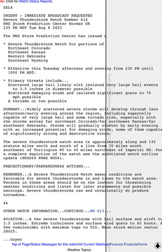
Surprising that SPC did not issue a tornado watch for northeast CO / northwestern KS yesterday, considering there was a 5% TOR risk - that may be a fairly frequent occurrence (I remember at least a couple days like that in NM this past spring), but in this case they had enough concern to explicitly mention supercells and tornados in the watch text, so why not issue a tornado watch?

Combined with the warning issues Mike has highlighted, one wonders whether the NWS is purposely trying to over correct for false alarms and a desensitized public…

CD63C9FC-CB45-48B5-AAE9-BCA09B7DAF48.jpeg
 
Brandon copic just had a tornado on his feed. People are tweeting it to nws Kansas city. Lots of folks in the live chat asking how can the NWS not issue a warning with the radar data and ground truth. He is still live streaming a rapidly rotating wall cloud north of Cillicothe (sp) with funnels and no tornado warning.
 
Brandon copic just had a tornado on his feed. People are tweeting it to nws Kansas city. Lots of folks in the live chat asking how can the NWS not issue a warning with the radar data and ground truth. He is still live streaming a rapidly rotating wall cloud north of Cillicothe (sp) with funnels and no tornado warning.
Screen grab he posted
 
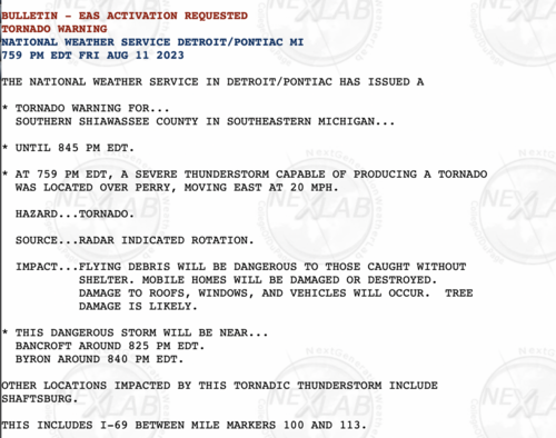
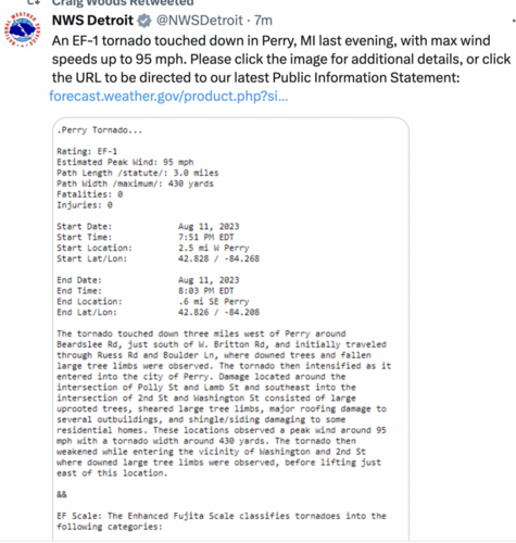
In addition to the Missouri miss, the NWS didn't warn on a tornado near Perry, Michigan, last night.

Please contact your congressional representatives!
 
The NWS did not issue the tornado warning for Perry until after the tornado had been on the ground for eight minutes.
Screen Shot 2023-08-12 at 10.38.21 AM.pngScreen Shot 2023-08-12 at 9.44.42 AM.pngScreen Shot 2023-08-12 at 9.44.42 AM.png
 
For the record:
  • The Perry MI tornado warning was issued only after the tornado had been on the ground for eight minutes.
  • The tornado 7 mi. northeast of Chillicothe MO was completely unwarned. I have posted the 11pm inbounds and outbounds for anyone who may wish see them.
As frequent readers of StormTrack know, there was a lot of controversy when I began calling attention to this huge issue with the National Weather Service.

Given that chasers were calling the respective NWS offices in these situations and, especially, in the missed EF-2 in Illinois this past Sunday, I have to ask: Has the NWS exited the tornado warning business and failed to inform us?!

There is no excuse for these. For those of us who are meteorologists, it is especially galling because it makes all of us -- and the field of weather science -- look terrible.

For those who are not aware: I tried bringing all of this -- twice -- to the attention of the very top management of the NWS in January. They insisted there is no problem.

It is unfortunate, but I believe it is incumbent on us to inform Congress. The general public will continue to believe their "complex situation" excuses because they don't know any better.

Over the summer, we've already had eight precious human beings die in unwarned tornado situations. Do we have to have another (poorly warned) Joplin before anything is done?

Please contact your congressional representatives. It is easy to use their web sites.
 

Attachments

  • 11p Chilicothe miss, inbounds.png
    11p Chilicothe miss, inbounds.png
    1.9 MB · Views: 0
  • 11p Chilicothe MS.png
    11p Chilicothe MS.png
    2 MB · Views: 0
Last edited:
And..... here we go again.

I was quite surprised SPC did not include a risk of tornadoes in its severe thunderstorm watch that included Tennessee late this morning. So, I mentioned -- twice -- that I thought there was a risk of tornadoes.

Sure enough, just before noon, a QLCS circulation developed on the leading edge of the line. As you know, I believe the terms "tornado watch" and "tornado warning" should be reserved for the NWS. And, unfortunately, the NWS SVR did not include a "tornado possible" tag.

So, I tried to get peoples' attention to the threat by mentioning rotation with the intensifying storm near Rural Hill. Sure enough, the rotation tightened a bit, a leading edge hook developed and there was significantly lowered. CC.

NWS BNA issued a tornado warning but it certainly seemed late to me. I get that some offices have more or less given up on QLCS tornadoes but, if an office is going to warn, it should be done when the ingredients first come together.
 

Attachments

  • Screen Shot 2023-08-12 at 12.28.25 PM.png
    Screen Shot 2023-08-12 at 12.28.25 PM.png
    1.7 MB · Views: 0
  • Screen Shot 2023-08-12 at 12.28.38 PM.png
    Screen Shot 2023-08-12 at 12.28.38 PM.png
    1.1 MB · Views: 0
  • Screen Shot 2023-08-12 at 12.24.47 PM.png
    Screen Shot 2023-08-12 at 12.24.47 PM.png
    1.1 MB · Views: 0
  • Screen Shot 2023-08-12 at 12.26.10 PM.png
    Screen Shot 2023-08-12 at 12.26.10 PM.png
    1.8 MB · Views: 0
  • Screen Shot 2023-08-12 at 12.26.27 PM.png
    Screen Shot 2023-08-12 at 12.26.27 PM.png
    1.8 MB · Views: 0
  • Screen Shot 2023-08-12 at 12.26.39 PM.png
    Screen Shot 2023-08-12 at 12.26.39 PM.png
    1.7 MB · Views: 0
  • Screen Shot 2023-08-12 at 12.19.10 PM.png
    Screen Shot 2023-08-12 at 12.19.10 PM.png
    967.5 KB · Views: 0
I hear Detroit Lions fans were fussing over tornado warning coverage….that’s dumb jocks for you… Sports fans grousing might be having an effect
 
You wouldn't think so...I wonder if there has been a dumbing down of standards. Maybe the term "tornado emergency" makes people wait to pull the trigger later.
 
Back
Top