2024-05-21 EVENT: IA/IL/MO/KS/OK/AR

KDMX showing some S-shape (V-B) going on above 2 km. Making me hypothesize that this may be the reason we're not necessarily seeing "clean"/discrete supercells. Or perhaps it will somewhat suppress the total extent of tornadoes in what seems to be an outbreak developing.
 

Attachments

  • KDMX_loop.gif
    KDMX_loop.gif
    956.5 KB · Views: 15
That was quite the cell along US34 producing multiple tornadoes, and fairly visible at that. Cells to the south appear ready to join in on the party and it will be interesting to see if they can maintain their minimal spacing in what is currently a broken line.
 
Have observed 4 tornadoes so far between Red Oak and Stringtown, IA, 2 at within a mile (audible). Red Oak observed full life cycle. Next two at their beginning stages, the third looks to be the one that struck Greenfield and the wind turbines at Carl. Fourth near Stringtown but buried in rain with low contrast. Really shocked at how this day evolved, did not expect this at all.
 
I started a report page wow what a day. East of red oak somewhere we were very lucky that people didn't get hit by that tornado cuz large metal went over the road at that time.
 
Can anyone think of a significant outbreak that happened with storms right on a surging cold front? I can't. So my current plan is to focus on storms ahead of the front.
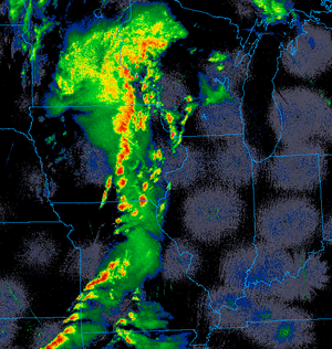
I might be imagining things, but it looks like many of the storms in southern Iowa / northern Missouri are just ahead of a diffuse cold front, possibly outrunning it. And indeed there are now some storms further out into the warm sector near the IA/MO border.

05212024 2245Z.png
 
I saw this solution on yesterday evenings HRRR run which seemed to show a phasing of the initial line which was replaced by a separate line out ahead of the initial main QLCS... I don't know if that was due to enhanced confluence or not, I see that on occasion but it's definitely happening.

another thing, looking at the Hodo and the cross over winds, it just seems like todays tornadic producing cells were , well, radar "ugly". I'm guessing both the 1-3km SVC wasn't lined up well next to the 4-6KM winds on top of it? (in terms of photogenic and radar presentation)

Next Day Edit

I just saw Jeff Duda's post above... yup, what he said! lol.
 
Last edited:
A personal comment:

A chaser (I don't think he is affiliated with StormTrack) posted a photo of the tornado going through also hard-hit Caroll IA yesterday with a big debris cloud and said the image was "beautiful." While I get what he meant, believe me, no one outside of our community thinks a tornado with a cloud of the objects of peoples' lives is "beautiful."

Please be mindful of what we say and write in these circumstances. Thanks for considering.
 
I had to post this.taken from RT video of the greenfield tornado and compared the sub vorticy pictured to Leigh orf's 10m resolution simulation presentation at the 100th annual AMS conference of vorticity magnitude. It was pretty amazing to see modeling come to life like that.
 

Attachments

  • Screenshot_20240522_064457_YouTube.jpg
    Screenshot_20240522_064457_YouTube.jpg
    89.5 KB · Views: 11
  • Screenshot_20240522_212514_YouTube.jpg
    Screenshot_20240522_212514_YouTube.jpg
    211.7 KB · Views: 11
Back
Top