2024-05-06 EVENT: TX/OK/KS/NE

Joined
Jan 14, 2011
Messages
3,129
Location
St. Louis
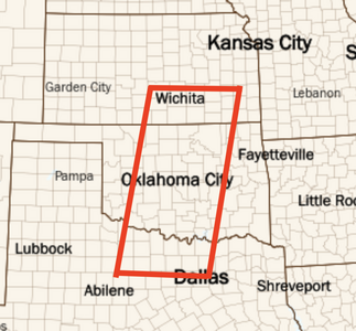
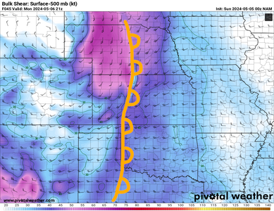
Medium-range models have shown consistency and agreement on a negatively-tilted shortwave trough ejecting over the central and southern Great Plains on Monday May 6. This is shown occurring over a large warm sector with ample moisture ahead of a dryline with a breakable cap from north Texas through Nebraska.

At this early stage in the forecast cycle, models have been wavering on the timing of the wave's ejection over the Plains. This is ranging from an ideally-timed major tornado outbreak scenario to an early ejection with storms firing at mid-day. Today's runs have trended toward the latter.

From a chase trip planning standpoint, models have been trending toward this being a single-day Plains event, with subsequent events potentially being far to the east and south in the Midwest or Arklatex. Still, strong flow and deep moisture are regionally coexisting on those days and subsequent Plains overlaps of the two may come to fruition.
 
12Z global models seem to be slowing the progression a bit relative to last night. There seems to be a lot to like about this setup in addition to just the appeal of an aptly-timed central plains negative-tilt upper trough in early May. The 12Z GFS likes a modest EML eroding by mid-to-late afternoon, with a sharp dryline extending south from a surface low. Storm motion is expected to be roughly orthogonal to the dryline and 0-2km wind profiles will provide support for what seems likely to be a line of discrete/semi-discrete supercells popping off the dryline. I think this will be in range of some of the CAMs soon which I expect to support the idea of several hours of discrete mode.

For me, items of concern are the slightly just in time dew points and predicted cloud cover. As usual, it bears watching the evolution of Sunday's convection.

If I were chasing, I'd target the dryline bulge in central Kansas. There's a lot of reasons to be bullish about this event, but maybe I'll avoid the jinx by expecting the ingredients to fall apart by Sunday.
 
Wonder about mode on this one. Seeing rather unidirectional hodos but for some good turning below 850.

I agree with this. Definitely a chase day, but mid-level shear sucks. HP storm mode likely.

I'm biased because I can't chase anyway. Too many work commitments, especially ahead of my chase trip that begins 5/13. Wish I was the type to say screw it and head out for this. But I'm not, so I look for failure modes :)
 
As shown now, the southern Nebraska/northern Kansas zone on the northern half of the arc back into the low looks prime as long as the 60F dewpoint line can make it up there. The NAM's low-level hodographs look pretty solid most anywhere north of I-70 despite the linear look suggested by some models' simulated reflectivity. This is looking like another "trip to Salina the day before", expecting to either go north or a little west in the morning.

The meridional flow/linear mode issue is a concern now, as is the potential for early-day cloud cover. That's something that is almost always there to some degree with a big wave. But a system like this coming into the Plains in May with moisture mostly in place? "If it's May, you chase" applies with even a tenth of what's shown (especially in a year like 2024 that seems to want to produce). Meteorologically speaking, I can't see a reason to ever turn my back on a setup like this if I have the ability to be there.
 
This is a somewhat mesoscale post 60 hours out; so, take it for what it is. It needs to hold until it's at or inside 36 hours.

12Z Saturday NWP for Monday shows a secondary jet max in the southern stream, punching into OK/KS, south of the teardrop mess north of KCMO. LLJ responds from OK into southern Kansas. Related, another subtle east-west boundary is forecast to lift from OK into KS and perhaps intersect the KS DL bulge. This secondary TP would be well south of the possibly occluded mess north of KCMO.

The downside is the farther south, the closer to mega chaser convergence. Situational awareness will be critical.
Sorry--can't find station KCMO--where is that? (Thanks!)
 
Sorry--can't find station KCMO--where is that? (Thanks!)
It is how natives describe Kansas City, MO. There are three primary wx stations in the KC area:
  • KMCI = Kansas City International Airport, north of downtown KC
  • KMKC = Downtown KC Airport
  • KIXD = Olathe, New Century Airport, southwest part of the Metro
There are several other ASOS but those are the primary.
 
Here are my initial thoughts regarding Monday.

If I were a lead forecaster at SPC, I'd be going moderate (15%, hatched) in the area in the sketch. I'd go enhanced (10%, hatched) north from the red outline into southeast Nebraska, include KC to MLC to ACT.

In theory, when SPC went from 3-levels (SLGHT, MODERATE, HIGH) to 5 (MARGINAL, SLIGHT, ENHANCED, MODERATE, HIGH),nothing was supposed to change w/r/t Moderate and High. In reality, SPC treats moderate like "high" in the old days.

While it doesn't matter much to me whether they go HIGH* or not, it wouldn't surprise me to see a high issued in the 11:30a or 3pm Monday outlooks.

If I chase Monday (and I may), I'll probably stay in Kansas because of the better road network and I think it could be prime for tornadoes.

Addition at 5:45p Saturday: I've been playing with the SPC climo for the past hour and, at surface, 500 and 250mb, Monday looks a lot like May 8, 2003. If it were a perfect analog, my red area should be moved about 70 mi to the NNE. Still think my outlook is pretty good but the climo is something to keep in mind and reinforcing my decision to chase in Kansas.

And, 5-8-03 was a HIGH risk day.
 

Attachments

  • 5-6.png
    5-6.png
    499 KB · Views: 9
Last edited:
Interesting setup. While some CAMS show over 4000 MLCAPE in mid Oklahoma, the forcing isn’t as strong there and there’s a chance nothing goes up there at all. I think the CAPE numbers are inflated a bit, but at least a couple of storms will pop. Going farther North there’s a very real possibility that a lot of the storms in Kansas will line out before getting the chance to fully organize. That would seem to make the case for a happy medium and going to Southern Kansas. The only troubling issue I see with that is the amount of trees East of Wichita. It’s not as bad as it is East of I-35 in Oklahoma. It is a concern though. The wind profiles are good throughout the region , but a bit better in Kansas than in Oklahoma where the lapse rates look a smidge better. I’m thinking of getting some help from GOES in the morning hours and letting the best daytime heating make the call for me.
 
I might be subconsciously biased since I have a final ending at 3:30 and won't be able to make the Kansas mode, but I lean more toward the Oklahoma mode. NWP suggests that shear vector orientations will be much more favorable for discrete convection further south and less favorable north of Dodge City. Forcing is admittedly weaker, but I think the height falls from the trough ejection will still be enough to get it done. I'm currently planning to chase southwest or west central Oklahoma, and I'll take a risk of a blue sky bust in exchange for a better chance of discrete convection if storms do manage to fire.
 

Attachments

  • 1714876510252.png
    1714876510252.png
    650.8 KB · Views: 9
That's quite the shift in the surface/dryline pattern from 36 hours ago. The model signal for storms south of the OK/KS border at 00z in the better CAPE is pretty strong now, and that's a scary environment. Scary not only tornado-wise but chase-terrain-and-roads-wise east of 35. I'm not sure I buy Kansas completely lining out, though. There's not much difference in that environment between a squall line and closely-spaced tornadic supercells going nuts. That being said, I may shift my overnight spot from Salina to Emporia to hedge a little south. I'm nervous doing that, though, with fast NE-moving storms. Hedging more north toward I-70 keeps the border action in play if needed, but rules out making anything in Oklahoma. The OK storms' more easterly motion would be great if it were just 100 miles farther west. Will be watching and hoping for a slower and farther west trend for that reason.
 
Both Euro and NAM have the dryline close to the OK border with the TX PH. GFS, not surprisingly, is more progressive so I would probably discount that. Should be plenty of “room” to chase west of I-35. The scary scenario is the typical craziness in that region with chaser hordes, congregating around a likely fewer number of discrete storms, combined with rush hour traffic around OKC, and fast-moving storms. At least it’s not a weekend, so maybe fewer chasers and local yahoos, but rush hour traffic will be a factor the closer you get to OKC. I typically don’t let chaser convergence affect my chase targets, but this time I’m not so sure. But I won’t be out there anyway, so I don’t have to make that decision. Be extra careful everyone!
 
NAM3K has a discrete cell going up near Altus. There's agreement in guidance with jet placement in the SW corner of Ok around the 00z timeframe. A possible secondary low in the NW corner looks to occlude and produce some focused convergence, while a shortwave comes through to help with CI. CAPE should be plentiful, although helicity doesn't take off till near dark with the help of the low level jet. There's been a fair amount of change in guidance on the placement of parameters in just the last 24 hours, but like Amelia, I Iike the southern play for better storm motions, even if it means blue skies. I'd like to think that area around Altus will shape up nicely in the next 24 hours.
 
For late Monday afternoon into early evening, a region south of I-40 in southwest Oklahoma, initially along a line west of HW 283 and along HW 62 [Altus/Hollis] within a forecast rich Theta-E regime, backed southeasterly surface winds, subtle diffluent 500 flow and ahead of a suggested dryline bulge has a potent hint at this point [typed at 9:30a on Sunday 5/5]. The caveat to this potential scenario unfolding at all is the forecast 9-11° C temperatures aloft which would/could suppress development or on the other side of the equation, enough parameters align to allow for perhaps one or two supercells to develop by early evening in that regime as some CAMs allude to. Obviously geospatial differences will happen regarding actual dryline position, even pushing this suggested focus zone south of the Red River to near or south of Vernon, Texas. This is not to detract from another concerning zone well to the north along to east of I-35, ITC east along the OK-KS border, in the late afternoon through evening hours in a region that has already been recently socked with severe weather, tornadoes and flooding. After dusk and into the overnight hours does get very concerning for tornado potential for Central and Eastern Oklahoma, but would personally not pursue that activity. For the moment, the southern option is where I would venture towards for either a tornadic supercell or two before sunset, or a complete bust and a visit to a local Braum’s.
 
It appears waking up late means everyone has already gotten around to posting my thoughts on tomorrow's setup 😅 I have nothing to add meteorologically, but from a chasing perspective, tomorrow might have to be an "ask my boss for a favor" type of day. If I can leave Altus soon enough, my current plan would be to target the US-183 corridor. The thinking is to allow storms to fire to my west and move east-ish off the dryline, and utilizing the N-S highway to fine tune my position. Hopefully being so familiar with the local roads in this part of OK could allow me to minimize my interactions with chaser convergence. Or maybe even the windier and hillier terrain around the Wichita Mountains could discourage folks from venturing out this way? After literally getting stuck in traffic on 27 April, and being lucky we were chasing the tail end storm, I don't want a repeat that tests that luck again.

If I can't leave Altus soon enough, then I suppose I'll be using my standard "frantically play catch up" style of chasing to hopefully see something before dark. Should be an interesting day regardless. Be safe out there folks!
 
For late Monday afternoon into early evening, a region south of I-40 in southwest Oklahoma, initially along a line west of HW 283 and along HW 62 [Altus/Hollis] within a forecast rich Theta-E regime, backed southeasterly surface winds, subtle diffluent 500 flow and ahead of a suggested dryline bulge has a potent hint at this point [typed at 9:30a on Sunday 5/5]. The caveat to this potential scenario unfolding at all is the forecast 9-11° C temperatures aloft which would/could suppress development or on the other side of the equation, enough parameters align to allow for perhaps one or two supercells to develop by early evening in that regime as some CAMs allude to. Obviously geospatial differences will happen regarding actual dryline position, even pushing this suggested focus zone south of the Red River to near or south of Vernon, Texas. This is not to detract from another concerning zone well to the north along to east of I-35, ITC east along the OK-KS border, in the late afternoon through evening hours in a region that has already been recently socked with severe weather, tornadoes and flooding. After dusk and into the overnight hours does get very concerning for tornado potential for Central and Eastern Oklahoma, but would personally not pursue that activity. For the moment, the southern option is where I would venture towards for either a tornadic supercell or two before sunset, or a complete bust and a visit to a local Braum’s.

This is the best play IMO. It’s where you have strong upper level flow nosing in along with a more westerly component to it, leading to more perpendicular flow to the dryline. This is where the better shear vectors reside leading to more discrete storms. It could be later on in the evening but seems to be the better play.
 
After literally getting stuck in traffic on 27 April, and being lucky we were chasing the tail end storm, I don't want a repeat that tests that luck again.
A well advertised severe weather event, single supercell scenario within Oklahoma or either side of the Red River in early May, regardless of it being a weekday = increased gonzo chaser traffic, crowded main roads, erratic drivers, potential accidents and the type of day I tend to avoid at this point, certainly when long-distance travel from MI is involved. Will bypass actually chasing this event in favor for other convective scenarios later in May/June, yet definitely echo the statement/s to be extra safe out there regardless of what transpires.
 
When my final ends at 3:30 tomorrow I'm gonna need to make a choice of northwest vs southwest vs west central Oklahoma very quickly and commit to it. My final is just a presentation instead of an exam and my professor is pretty supportive of my chasing, so I might be able to get my presentation done near the start and leave early. Not looking forward to the convergence, might be making a special effort to keep my distance tomorrow.
 
Back
Top