• A friendly and periodic reminder of the rules we use for fostering high SNR and quality conversation and interaction at Stormtrack: Forum rules

    P.S. - Nothing specific happened to prompt this message! No one is in trouble, there are no flame wars in effect, nor any inappropriate conversation ongoing. This is being posted sitewide as a casual refresher.

2024-04-26 REPORTS: IA/NE/KS/MO/OK

Fortunately, I haven't gone empty handed today. This was just west of Fredonia, KS around 3:50pm. This tornado lasted over 15 minutes. Currently in northeast OK trying to intercept a supercell coming out of Tulsa, but it has been struggling so far. Today is going to be a day we talk about for a while. Congrats to everyone who scored.Screenshot_20240426_171350_Gallery.jpg
 
Don’t have any pictures to share because I was the one driving and storms are still ongoing. Saw four tornadoes and several houses being destroyed. Most of the people I saw that stopped to help were chasers who stopped chasing instead of continuing on. Kudos to all of you who stop and offer aid. It does make a difference. Just posting about it now because I’m old and forget things😊
 
(edits, thought this was a report thread for some reason, oops)

Memorable day. Started out in Western Iowa and once I saw Eastern Nebraska was coming together targeted Lincoln, NE. That worked out well. Chased that cyclical supercell until it reached the Omaha suburbs. Got east and reposition. Picked up the Shelby Iowa area tornado as it crossed and followed it north a bit. Probably a half dozen tornadoes on a couple of cyclic supercells. Terrible to hear about all the damage done, hopefully no lives lost. An outbreak that will not soon be forgotten and a top 5 day for me.

(would have kept going long but windshield wipers failed, will figure out what's up with that tomorrow -- at any rate, what a way to kick off 2024 chase season, eh?)
 

Attachments

  • A7R05972.jpg
    A7R05972.jpg
    224.5 KB · Views: 28
  • A7R05882.jpg
    A7R05882.jpg
    157.5 KB · Views: 30
  • A7R05832.jpg
    A7R05832.jpg
    227.4 KB · Views: 29
  • A7R05926-Enhanced-NR.jpg
    A7R05926-Enhanced-NR.jpg
    280.3 KB · Views: 30
I have a ton of imagery to include later, but wanted to hammer this account out while it is still fresh. I awoke in Salina to pessimism about the day when looking at morning data. It appeared that the best upper support would stay well to the south and east of the primary surface low target where they typical arc of supercells was expected. Moisture also did not seem as robust as forecast, and with midlevel winds more southerly than forecast, it appeared that directional shear would also not be as good as expected earlier. Nonetheless, a deep low would have tons of ambient vorticity to help offset those problems, so I felt that it remained the best target of the day.

I stopped for coffee and to look at data for a while in Concordia, then moved slowly north to York. I was tempted to go after the early storm at the center of the low once the reports from it started flooding in, but felt that the arc of supercells farther south would have similar potential.

My target storms fired a little farther south than I'd thought/wanted, but after the lack of agitated cumulus made it clear nothing would be filling in between those two areas, I headed south to Wilber to get in front of the best-looking storm. I drove past another storm to get there that looked promising, but I felt that it was at risk of getting cut off by the Wilber storm. I arrived in Wilber as the storm's first tornado warning was issued, but the storm did not look like it was yet ready.

I stayed with the storm northeast through Hallam to Lincoln, where I lost the core's race to the I-80 interchange west of town. I did not want to risk getting stuck on the interstate by hail-spooked motorists parking under overpasses, so I went through downtown to I-180 to get on the interstate eastbound. I did not have a good visual on what was happening to my south due to heavy rain, bad terrain and traffic, so I missed capturing the beginning of the tornado on my better cameras. Once I got clear of the precip, I found a safe place to stop along the interstate (off of the pavement) to get my camera set up. Lots of motorists were also stopping (as well as chasers) as the highly-visible tornado approached.


The "waterfall" sound was clearly audible, and while the tornado was strong, it had an almost soft, graceful feel to it as it approached. This changed as it encountered a commercial structure. The tornado roared loudly as it lofted a large amount of debris. It crossed the interstate about a half-mile to my east.

I got back on the highway intending to move north once across the Platte River (I did not want to get trapped without a river crossing). During this move east, more tornadoes were visible - possibly three separate ones, including one that looked like it was on the RFD gust front and anticyclonic. I honestly don't know what happened during this time as I could not keep an eye on it from driving. It may have all just been the same tornado.

My plan to re-intercept the storm north of Gretna was a mistake. The road was congested with traffic, and long/non-timed lights were stopping me at every cross road. I finally made it to Highway 275 to see the start of a large tornado to my northwest. I did not get any pictures of this due to not being able to find a view (terrain, trees and buildings made it impossible). With more storms approaching from the southwest, I decided I didn't want to be stuck in the Omaha metro any more, and bailed to the interstates and the northeast into Iowa.

When I re-intercepted the storm at Modale, a new tornado was developing with the next meso cycle, while an old tornado emerged from the rain behind the RFD gust front. The old tornado roped out, but its circulation remained visible moving through the town.

april2624d.jpg

I had to let the storm go to get gas in Logan. After this, I moved south to Beebeetown to intercept the next storm. It already had a tornado in progress when the meso became visible! I watched this approach for a short time before heading east to give it some more room, once again hearing the waterfall sound.


After this crossed I-80, I moved east to the next storm at Minden - and again, a tornado was already in progress when I gained a visual on the updraft region. The road from the north into Minden was closed due to construction, so I stopped at the crest of the last hill before town. I observed this tornado - the largest of the day - move into the town of Minden with a loud roar. As the tornado got a little to close for my comfort level, I moved north to give it some additional room and to observe it pass by to the east.


I followed behind it as it slowly shrank in size, watching it cross a dirt road about a mile ahead of me. After it had crossed the road, another tornado condensed to its south. This appeared to be a separate circulation.

I encountered a two-story house that had been struck on this road, stopping to assist. The house was still standing but was substantially damaged, all of the windows were gone. The lone occupant and his pets were OK, having ridden out the tornado in the basement. Another chaser stopped to help. We offered assistance, with the only thing he asked for was to get the garage door off of his mostly-undamaged truck. After neighbors arrived on scene, we both left.

I got back on I-80 and made the long trek through Des Moines down to Winterset where a tornadic supercell was fighting off surrounding storms. I observed a wall cloud with this storm to the southwest with difficulty, as the terrain/trees at that location were suboptimal. I decided to head down to a supercell ahead of the line at Osceola. I had a feeling of dread as the couplet was quite strong, and it appeared to be heading straight for the town. I observed a cone tornado approach the town and then vanished just prior to entering it, as if my prayers for the town were answered. I didn't see any power flashes nor did I encounter any damage when I passed through the town a few minutes later.

I observed what appeared to be a separate tornado getting started to the north of town, with multiple funnels visible under the wall cloud. This storm was moving much faster than the others, and it did not appear that I'd catch up again. I moved south to the tail-end cell in the line, which had a couplet and was tornado-warned, but had no visible structure that I could see.

I honestly don't know what my total count was for the day. Conservatively, it is at least 8. More if the tornadoes between Waverly and Omaha were separate events. Definitely a top 5 day for me. It's rare for me to hear the sound of a tornado, I heard the waterfall and roar three separate times.
 

Attachments

  • april2624c.jpg
    april2624c.jpg
    24.9 KB · Views: 61
Last edited:
I have so much to go through so I will post a couple now and add later. Video is here
Screenshot_20240426_184934_X.jpg
 

Attachments

  • Screenshot_20240426_183722_Gallery.jpg
    Screenshot_20240426_183722_Gallery.jpg
    95.6 KB · Views: 14
  • Screenshot_20240426_180714_Gallery.jpg
    Screenshot_20240426_180714_Gallery.jpg
    111 KB · Views: 11
  • Screenshot_20240426_173325_Gallery.jpg
    Screenshot_20240426_173325_Gallery.jpg
    61.8 KB · Views: 13
  • Screenshot_20240426_173045_Gallery.jpg
    Screenshot_20240426_173045_Gallery.jpg
    158.5 KB · Views: 13
  • Screenshot_20240426_173013_Gallery.jpg
    Screenshot_20240426_173013_Gallery.jpg
    216.3 KB · Views: 13
  • Screenshot_20240426_173018_Gallery.jpg
    Screenshot_20240426_173018_Gallery.jpg
    232.4 KB · Views: 11
  • Screenshot_20240426_173258_Gallery.jpg
    Screenshot_20240426_173258_Gallery.jpg
    95.3 KB · Views: 10
Southeast Kansas, Western Missouri
Cyclic Supercell and multiple tornadoes. [5-7 total observed].

The atmosphere was quite turbulent today in southeastern Kansas and western Missouri! A long-track, cyclic supercell thunderstorm produced multiple tornadoes, some quite visibly large, along a 112.5 mile path from north of Altoona, Kansas [southwest of Chanute] to approximately 3 miles east of Clinton, Missouri. I observed between 5 to 7 tornadoes, three at fairly close range [+/- one mile or less] in select open terrain between 4:15 p.m. CT and 7:55 p.m. CT.

Began the morning in Topeka with an initial FFZ [forecast focus zone] from Fort Scott to Parsons, Kansas and points east. Deep moisture return by mid/late afternoon into the early evening along a modulated dryline, with ample 500-850mb veering, forecast SB CAPE around the 2500-3000+ J/kg, Theta-e rich moisture tongue and some potential for locally backed surface winds in the along and south of Kansas-Missouri Highway 54 had my attention. After a quick lunch in TOP, the 1630 SWODY1 seemed to concur as I proceeded south on Highway 75 towards Chanute and Parsons. While in Chanute at 1:55 p.m., a rather elongated storm fired along the dryline east of Arkansas City and Winfield. 25 minutes later, a secondary storm, both of which were clearly becoming supercells, developed near Dexter, Kansas. The northern storm first went tornado warned, while the southern cell began to phase up and take on a distinct mesocyclone signature north of Longton, Kansas at 3:30p.

While I waited and watched the storms evolve on radar from Parsons, the southern storm began to go dominant and eventually absorbed the northern supercell. I headed north on KS Highway 59 and then west on KS 47 towards Altoona.

Note for anyone chasing Saturday, 4/27 in Southeast Kansas: KS Highway 59, between Highway 47 west and Kansas Highway 39, was closed Friday afternoon.

That closure allowed for a western direct B-line to the impressive supercell. Updraft and flank knuckles of cumulonimbus revealed as I neared HW 169 and 47 west of Altoona. The supercell was tornado warned by that point with reports of a confirmed tornado visually.

Eventually headed north out of Altoona to view the encroaching mesocyclone and wall cloud just at 4:09p CT off a side road just off Highway 75. Meso movement was gradually east southeast. Repositioned a mile south of the wall cloud that exhibited rapid rotation.

A tornado, observed at times as a cone vortex, soon developed to the west of HW 75 at apx. 4:15p CT and gradually became enshrouded in rain as the wet RFD wrapped. Headed east on a network of dirt grid roads as the tornado became visible again from my viewpoint looking north at 4:20p CT. The supercell cycled again [and would do this numerous times through the evening, per cyclic supercell nature], with a broad rotating wall cloud west of Chanute at 4:40 p.m. Sirens blared and many curious residents were out and about in town. I continued to meander and shift east/northeast along KS 39, taking a northward jog and then east from Uniontown. At points it did get a bit hairy with wet RFD wrapping into the cycling mesocyclone. Eventually when I cleared the edge of the hook and made it into the clear, a double rainbow cast boldly just to the east. Made it to Fort Scott, then drove north on Highway 69 as the meso/wall cloud approached, then shifted east on a dirt road grid taking the [finally] nicely paved “Valley Road” east over the Kansas-Missouri border.

On the western village limits of Stotesbury, Missouri a decent clear field presented itself just as the rapidly rotating wall cloud began to cycle up again. A lot of vorticity in the air at this point! A brief tornado first dropped down out of the forward flank of the meso. To the northwest of County Road D, the wall cloud, now with rapid rotation, produced another cone tornado with helix vortices about a mile or less to my northwest. Then it was time to shuffle east/northeast, again.

Between Rich Hill and Rockville, Missouri, the meso cycled again and produced at least two tornadoes. I stopped at 6:39p CT on County Road B and recorded additional video of another tornado to the north. Then continued the country road/highway stair step to Appleton City and Montrose. East of Montrose another tornado developed and quickly became enshrouded in rain, with the supercell often taking on high-precipitation characteristics. Headed north on KS 52 and 13 at Deepwater, Missouri, with a clear view of the cyclic meso/wall cloud to the west over the Harry S. Truman Reservoir.

At this point I was about to let the storm go, but proceeded east of Clinton on MO Highway 7 for one final wide view. Tripoded and watched the supercell and rotating wall cloud approach. At 7:35 p.m to the west of a local N/S road off Highway 7, approximately 2-3 miles east of Clinton, a very photogenic tornado developed and gravitated in my immediate direction. Between rain spurts, the environment became very still with the classic waterfall sound very audible. When the tornado was less than a mile away, I headed south and then east along Highway 7 for a dramatic rope out at sunset. A rainbow materialized soon after to the east, cast against the departing supercell. A beautiful turbulent sky sunset with mammatus concluded the scenery. Road networks and terrain cooperated surprisingly well at vital points of the storms tornado genesis during the entire day. Great chase day! Everything else is gravy from this point.
 

Attachments

  • 5.png
    5.png
    2.3 MB · Views: 11
  • 4.png
    4.png
    3 MB · Views: 11
  • 3.png
    3.png
    2.7 MB · Views: 11
  • 2.png
    2.png
    2.9 MB · Views: 11
  • 1.png
    1.png
    3.9 MB · Views: 11
Last edited:
I ended up leaving work in the late afternoon and headed west on US 34. Getting a late start. I do that. The play for me was going to have to be southwest Iowa. I was targeting the southern cells that formed in Northeast Kansas and Southeast Nebraska and as those moved into northwestern, Missouri and southwestern Iowa, they quickly became tornadic. I intercepted a cell Southwest of Creston that produced several tornadoes and then right behind it a new cell formed not far from the airport and dropped several tornadoes as it headed towards Afton. I chased with @Ethan Schisler and we ended up seeing a final tornado south of Osceola. Just as the sun was setting. It appeared that the tornado lifted just before entering town and there may have been some damage on the southeast side. It certainly was rewarding even though I wasn't able to get to the stuff up on the I-80 corridor.

1000010218.jpg

1000010211.jpg1000010216.jpg1000010183-01.jpeg1000010185-01.jpeg
 

Attachments

  • 1000010178-01.jpeg
    1000010178-01.jpeg
    104.7 KB · Views: 14
Adding the life cycle of that first tornado by lincoln. I woke up this morning in Omaha and heading to somewhere in Oklahoma for today.
 

Attachments

  • Screenshot_20240427_095148_Gallery.jpg
    Screenshot_20240427_095148_Gallery.jpg
    145.6 KB · Views: 15
  • Screenshot_20240427_095144_Gallery.jpg
    Screenshot_20240427_095144_Gallery.jpg
    158.5 KB · Views: 16
  • Screenshot_20240427_095139_Gallery.jpg
    Screenshot_20240427_095139_Gallery.jpg
    153.8 KB · Views: 16
  • Screenshot_20240427_095135_Gallery.jpg
    Screenshot_20240427_095135_Gallery.jpg
    188 KB · Views: 16
  • Screenshot_20240427_095055_Gallery.jpg
    Screenshot_20240427_095055_Gallery.jpg
    190.8 KB · Views: 14
  • Screenshot_20240427_095049_Gallery.jpg
    Screenshot_20240427_095049_Gallery.jpg
    158.3 KB · Views: 14
  • Screenshot_20240427_095040_Gallery.jpg
    Screenshot_20240427_095040_Gallery.jpg
    218.6 KB · Views: 12
  • Screenshot_20240427_095035_Gallery.jpg
    Screenshot_20240427_095035_Gallery.jpg
    118.1 KB · Views: 10
  • Screenshot_20240427_095028_Gallery.jpg
    Screenshot_20240427_095028_Gallery.jpg
    130.4 KB · Views: 12
  • Screenshot_20240427_095016_Gallery.jpg
    Screenshot_20240427_095016_Gallery.jpg
    282 KB · Views: 13
Left Iowa City around 11AM to Omaha. Did not want to cross the river to avoid chaser convergence as well as large hail, so stayed. on Iowa side. Caught up with this tornado near Shelby, Iowa from about a mile distance. Saw many chasers driving past me 90-100 miles/hr speed, I suppose rather risky. Glad there were no accidents or fatalities with this outbreak.
 

Attachments

  • tornado4 4-26.JPG
    tornado4 4-26.JPG
    284 KB · Views: 9
  • tornado3 4-26.JPG
    tornado3 4-26.JPG
    310.4 KB · Views: 9
  • Tornado1 4-26.JPG
    Tornado1 4-26.JPG
    219.3 KB · Views: 10
Likely the greatest chase day I'll ever have.
Need to review the footage, but I know I caught at least 12 tornadoes on 4 separate supercells (Lincoln>Omaha, Omaha/Council Bluffs, McClelland>Tennant, and Defiance) during the day.

More footage and pictures than I can even count at this point, but below are a few of the screen grabs, pics, and videos I caught on my phone. Gonna be uploading more footage over the next few weeks including a 360 video of the Minden tornado as it hit town.

Great job to the chasers out there helping to keep the public weather aware and assisting in S&R activities! That, and it being daytime led to a remarkably (borderline miraculously) low casualty total considering the intensity, coverage, and population density of the outbreak area.

Minden Tornado Developing


1000003876.jpg1000003878.jpg1000003880.jpg1000003877.jpg1000003847.jpg
 
April 26, 1991 was the event that made me wanna pursue storms as a career... 33 years later I had what probably will be my most intense storm chase of my career...

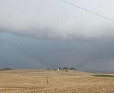
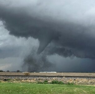
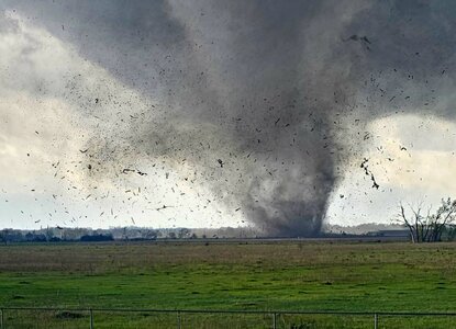
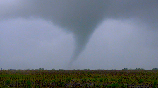
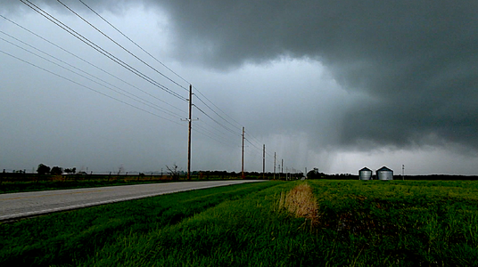
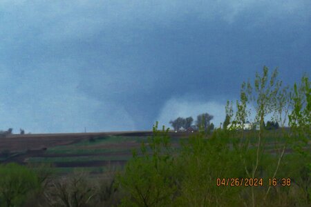
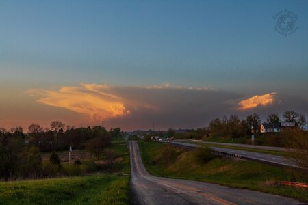
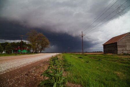
Chase partner Ed Grubb and I started the day in Concordia, Kansas... given the previous few events, in particular being burned on the April 16 event (running away from the surface low), we decided to make a b-line for the low north of Kearney. We had some reservations about whether this day was ultimately going to pan out (similar concerns to Dan and previous recent events). So after a lunch stop in Columbus, we shot back west as storms fired near Kearney and we rolled up to the storm east of Farwell, catching this brief little nader east of town. NWS Hastings says this was the initial stages of the Elba tornado, but this quick spin-up dissipated pretty quickly and we cannot confirm any continuous tornadic activity for a couple minutes after this lifted. I'd venture to say the main tornado was developing and this was a satellite of the big one based upon my observations.

fbFarwell1.jpg

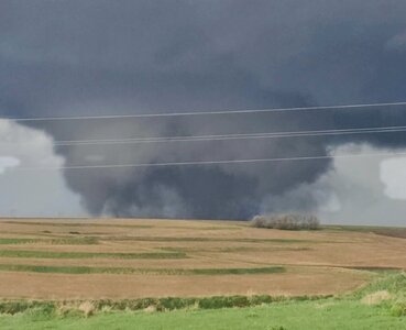
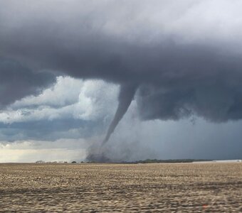
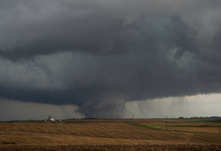
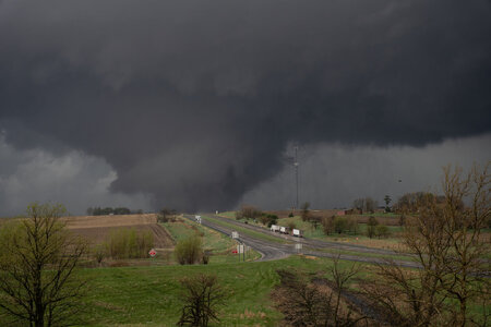
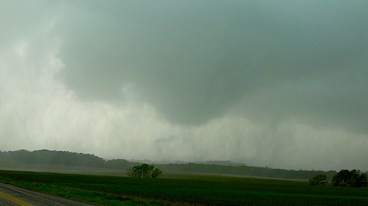
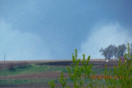
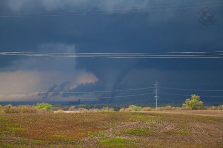
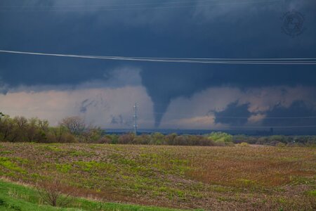
With the storm moving north/northeast, we flipped around to Highway 11 and came up through Elba, stopping about a mile or so north of town at the intersection with Odell Road where we put ourselves pretty close to the main circulation, which had a formidable RFD wrapping around. We stopped here for several minutes as it roared away to our immediate north. We watched the power poles on Odell Road come down one-by-one in the RFD, possibly a domino effect from the tornado taking them down further up the road.

fbElba2.jpg


fbElba01.jpg

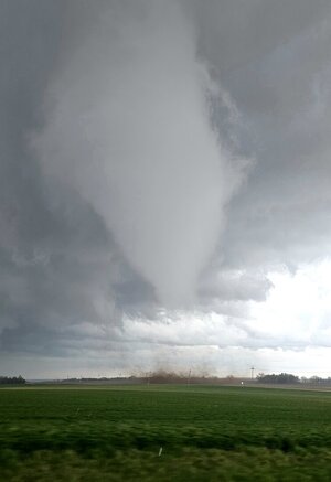
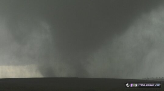
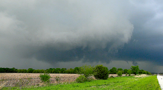
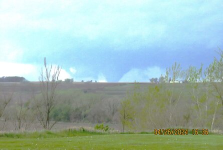
Once the RFD cleared and it was safe, we turned back around through Elba, shot east to St. Paul, then north on US-281 to make our second intercept of this storm. At the time, we thought we were observing the same tornado given the strength of the initial intercept north of Elba, but as Hastings has come out, this was a second, larger tornado southwest of Wolbach. This one we hung back about a mile or so as the visibility with this one was not nearly as good, so we opted not to chance it as close as the previous intercept. This RFD took down several trees in our immediate vicinity.

fbWolbach.jpg

We let the tornado clear and we proceeded north, then eventually east through Wolbach on NE-22. We were going to make one more attempt to get north, but the two roads we tried were mud, and we didn't want to chance getting stuck. We did try to stay with this storm, but could never get back into view enroute to Albion. About this time, we started to take note of the cells near Lincoln, and figuring the next round of the show was about to begin. We started to passively make our way east with other storms forming to our south, but once the tornado reports starting pouring in, we committed to the east route.

While that drive was going on, reports and images starting pouring in from the Lincoln/Omaha storms, and we were plotting a way to get across the river into position where we could actually intercept them. We hauled east on NE-91, going through the town of Snyder, and we discussed the two options before us. One was the quickest route to the storms, southeast through Scribner via NE-91 into Blair and crossing the river at Missouri Valley. We were immediately concerned with the potential of getting stuck in the damage path, and never getting ahead of the storms. Our other option, and the one we opted for, was to take the northern route via NE-51. We gauged the storms were moving at a slow enough speed that would allow us to get across the river at Onawa, then take the southeast route via IA-37 to get in front. That ultimately was the decision that made the second half of our day possible.

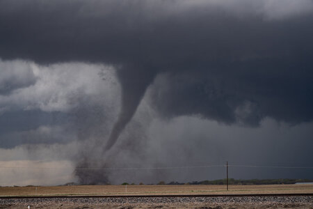
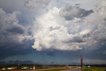
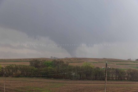
So it was about an hour before we got into Iowa, and when we did, the target storm was the one heading for the Harlan area. We had one storm to the north that we'd tangle with enroute, but by far the most impressive storm within our reach was the next one down the line. We needed to make Dunlap for a fuel stop, so that was the main goal at that moment. Turns out, the northern storm we were gonna skirt was producing a tornado taking aim on Soldier, and when we realized we could beat it there, we made the stop and observed this tornado briefly, crossing back to the northwest to the other side of town where a less definitive tornado ripped through the trees northwest of town. We didn't stay too long; just padded the stats and proceeded with gas and got ready to intercept the 'Tornado Emergency' coming up from Harlan.

fbSoldier1.jpg

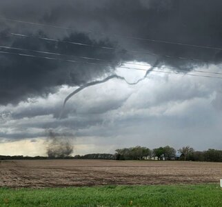
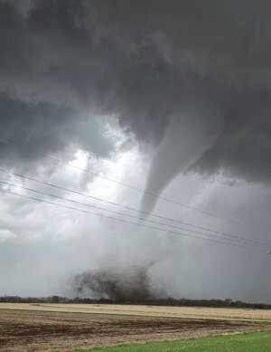
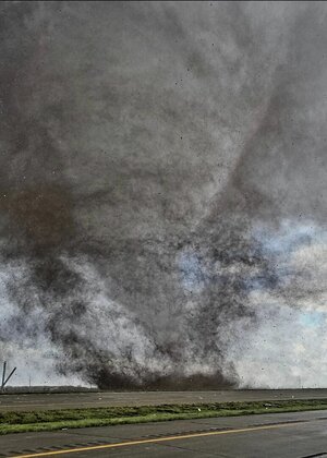
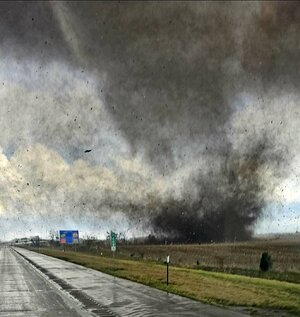
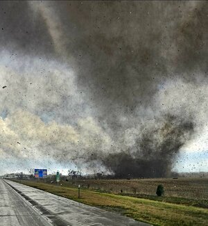
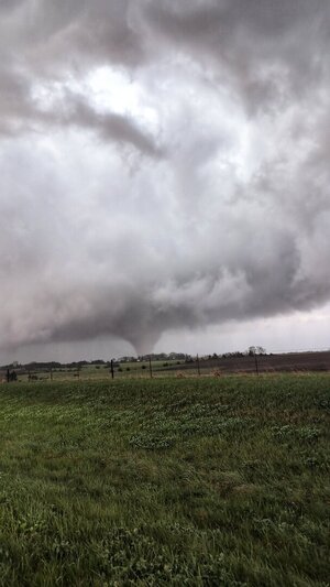
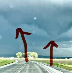
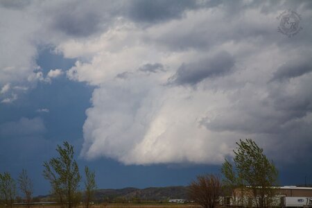
By this point, I was prepping for my 6PM live hit with AccuWeather. We were rolling through Earling just before the top of the hour when Ed got a visual on the lowering through the trees and hills to our south. We were approaching US-59, and the initial plan was to peel north to get in better position, but when we arrived at the junction and it was clear the tornado was still a ways to the south, we opted to poke south about two miles to setup on a hill with a great view of the approaching tornado. All this while we went into the live hit and crested the hill as I went on air with the tornado in full view.

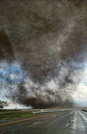
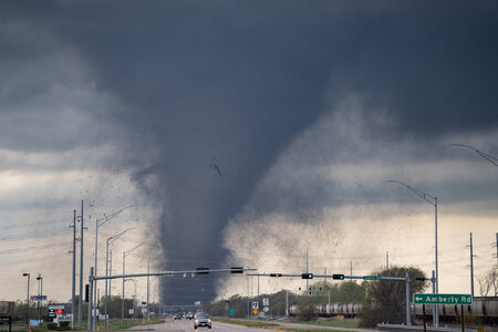
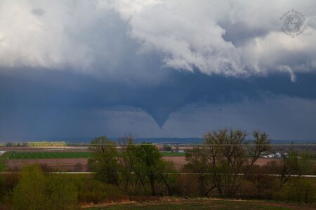
For the next 25 minutes, I was giving a play-by-play of this tornado live on the AccuWeather Network as it churned its way in our direction. Once it got within a couple miles, the contrast was divine. It isn't often when you can get a view as pristine as we had coming in from the north. Aside from about 60-seconds of hail approaching 2", we were mostly precip-free til the tornado got right up on us. It made for one of the best TV moments of my career with a clear picture of the approaching tornado and great live coverage.

fbShelbyWedge01.jpg

fbDefiance.jpg

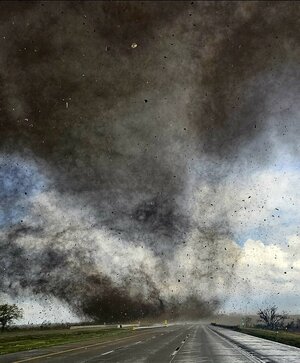
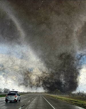
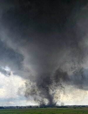
I'd say we were probably kissing the north edge of the parent circulation. This tornado wasn't always fully condensed at ground level, but as it crossed Highway 59 to our immediate south, I'd be lying if I said we were more than a quarter mile from the northern edge. All the while, the occasional sub-vortex would spin up and rifle right to left across the highway. I feel like it took several minutes before the circulation fully cleared the highway, all the while giving the play-by-play on the network as it did so.

fbShelbyVort1.jpg

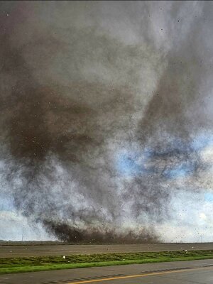
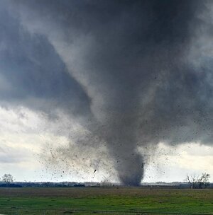
Once the tornado cleared the highway, we flipped back around to the north, taking a series of county roads immediately behind the tornado as it narrowly missed Defiance to the east. Occasionally part of the main circulation would condense, all the while little vorticies would spin down, but it stayed churning on its way to Manilla.

fbDefianceLightning.jpgWe eventually ended up on IA-141 heading east toward Manilla where what appeared to be a satellite circulation developed in the field immediately to our south and crossed literal feet in front of the hood.

fbManillaMini.jpg

We let that storm go as more tornadic storms were coming up from the southwest. We ended up dropping south into Audubon where we opted to close out the chase after watching two storms go by the area. With darkness falling, we called it a chase. In total, six tornadoes, starting as early as 12:45PM. The most impressive without question was the Harlan-to-Manilla intercept which we had most of it aired live as it was happening.

FIRST PART OF THE LIVE COVERAGE OF THE SHELBY COUNTY TORNADO EMERGENCY ON ACCUWEATHER

The chaser in me had some brief bouts of regret with our targeting of the early storms, costing us a chance at the Lincoln-to-Omaha tornadoes. Those certainly were the most visually impressive of the bunch, and certainly had the most impact. But I was very happy that we were able to secure the early tornadoes north of Kearney and still make it east with the very wise decision to take the northern crossing, which allowed us the opportunity to document the back end of the Harlan tornado. This chase could easily rank as number 1 for intensity/experience given the close proximity to several of the larger tornadoes we encountered, and the Harlan tornado definitely was a top-tier intercept. Obviously it was most certainly NOT the result we wanted to see having so many destructive tornadoes in populated areas. It's always a double-edged sword when that happens, particularly to the extent that it did this day (more so the following night).

Definitely a day to remember... major kudos to my chase partner, Ed Grubb... we've chased together for many many years at this point, and his eyes and call outs made what would've been a very stressful solo chase much easier and successful.
 
Wondering if anyone got twins during this event? I was told, but couldn’t confirm, that there was twins in Iowa. I thought I had two mesos in front of me in Iowa at one point, but haven’t seen any pics of twins yet.
 

Attachments

  • IMG_0868.jpeg
    IMG_0868.jpeg
    92 KB · Views: 6
Wondering if anyone got twins during this event? I was told, but couldn’t confirm, that there was twins in Iowa. I thought I had two mesos in front of me in Iowa at one point, but haven’t seen any pics of twins yet.
There were several instances of overlapping handoffs with the Lincoln/Omaha storm. My dashcam time lapse video shows 4 of those. I also saw one instance of a satellite north of Minden (also on my log page)
 
Wondering if anyone got twins during this event? I was told, but couldn’t confirm, that there was twins in Iowa. I thought I had two mesos in front of me in Iowa at one point, but haven’t seen any pics of twins yet.
I still have so much to go through but here are a few off the top of my head.

As the first Lincoln tornado was roping out a second one started to the NE of it.
Lincoln.jpg

By Minden there was this that looked to be separate of the main circulation.
Minden.jpg

There were many vorticies around the tornado as it got closer to Harlan but they were still the same multi-vortex tornado and under the same meso.Harlan.jpg
 
First off on a personal perspective this was a pretty scary day since I live in Omaha. I’ve lived here 20 years and nothing close to this has happened before. We’ve had a few brief weaker tornadoes over the years, but this was on another level. The metro area overall did just dodge a bullet though as you can clearly see in the damage survey tracks how close both EF three tornadoes came to hitting the densely populated areas of Omaha.
My house was by about 7 miles to the west and 8 miles to the east by the tornadoes. My wife and two daughters wrote out the storm in the basement. I’ve taught my wife enough with radar that she never felt too scared. Plus, they were also watching the local news coverage.
I chased this day of course initially heading west on Highway 92 to northwest of Lincoln when the first storms formed near the Kansas and Nebraska border to the southwest of Lincoln. Initially, they were a small line but split into two dominant cells.
IMG_9821.png

I decided to go after the furthest northwest one figuring that I could still jump east to get on the next one if needed. This looks like a great decision at first as my storm really took off and developed a nice hook and couplet while the storm closest to Lincoln struggled a bit.
IMG_9829.pngIMG_9833.png

I came down to interstate 80 at the town of Goehner And expected to see something close to a tornado but oddly enough nothing was that impressive visually. Nonetheless, I dropped south of the interstate by a mile or so to watch the storm. Some decent rotation at times, but it looks to be slowly dying for whatever reason I decided to stay with it for a while as it moved to the north and followed it back to the north of the interstate. My first mistake. I should have left the storm at that point and jumped east on the interstate to get to Lincoln.

Staying too long with this storm and driving north to Highway 34, I finally pulled my head out of my ass and realized I needed to get East towards Lincoln. I watched the Lincoln storm go through one last cell merger, and then it was producing a tornado. I was able to see the base from my position and suddenly saw the big stove pipe tornado from probably 10 miles away. I made it to the interstate but ran into, very slow traffic where the tornado crossed flipping a semi and also noted the train derailment to the south of the interstate. I tried to catch up with the storm as it moved north towards western Omaha suburbs, but completely forgot about the Platte river and the limited crossings. I eventually got a decent view of the storm from the south, noting a very low wall cloud with rapid vortices swirling around underneath. Unfortunately, was not able to continue on roads that would lead me directly to the tornado so by the time I came into Western Omaha, I ran into the damage path and had to backtrack a bit. It was almost eerie to see houses I’ve driven by so many times over my 20 years living in the Omaha area damaged so badly. This was on highway 275.
At this point I decided to give up on trying to catch up with that tornado and instead looked towards the next tornado warren storm that was on the south side of the Omaha metro near Bellevue. I made my way around the north side of Omaha, stopping where interstate 29 and 680 split just to the north east of the airport.
This cell while tornado warranted for quite a while, hadn’t really come close to producing. I sat in rain and some decent hail watching the Eastern edge of the cell.
Suddenly rotation ramped up very quickly and a funnel, and then tornado touchdown to my south by a couple miles. Unfortunately, from my vantage point, the ridge of trees and hills that line the eastern valley of the Missouri river plain, were blocking my view. However, the Tornado rapidly grew in size, and I observed a couple of power flashes as it appeared to be tracking on the north side of Council, Bluffs, Iowa, and just to the south of Crescent, Iowa.
The tornado took more of a north track bringing it rather close to me.
IMG_0336.png

I was filming from inside the car, but wanted to try to hear the tornado so I stepped outside and crouch down in front of my car, hoping to get some shelter from the rain, wind and hail. As the tornado began to pass just to my east, the RFD Began to surge through and the hail increased in size so I jumped back into my vehicle.
I left the tornado go safely by to my east and then try to figure out a way to follow it with the roadwork in the Loess hills of Iowa. Once again, I came across damage that blocked my path, causing me to backtrack and lose that storm.
I drew my attention to the tornado confirmed storm to my Southeast. This would be the storm that hit Minden, Iowa. As I was approaching this one from the west I could once again see a large tornado on the ground from probably 10 miles away. I got close to the storm but made another mistake of staying on the highway just to the south of interstate 80 into Minden, which had just been hit.
As you know, the town suffered severe damage and basically every road had debris or trees on it. Despite multiple attempts to try to find my way to the highway on the east side of town, I was unable to, and once again had to backtrack to take a road to the interstate. At about this time is when the tornado was approaching Harlan, Iowa. I made one last attempt to get to the storm, but again ran into damage on the interstate where a semi had been blown over.
I drove for a bit, but realized I would not be able to catch up to the storm so I headed back home.
I’m disappointed to not have been able to see more of the tornadoes up close but the intercept I did have was pretty intense. I’ve included the video for that storm below.

 
Left Kansas City around 10:30 am with a SE Nebraska initial target. Latched onto a tornado-warned supercell that was near Lincoln as we were approaching the city from the east. Caught tornadogenesis of the Lincoln-Waverly EF3. Tried to reposition to continue following the storm but ended up leaving it due to our location and it's forward speed. It went on to produce the Elkhorn-Bennington EF3 not long after we left it. Repositioned to the south side of Omaha (near Offutt AFB) where we caught the Pacific Junction, IA EF1. We opted to call it a day and not follow into Iowa so we could get back home and prepare for the next day's chase.


Attachments

  • IMG_8385.jpg
    IMG_8385.jpg
    193.2 KB · Views: 3
  • IMG_1993.jpg
    IMG_1993.jpg
    154.4 KB · Views: 3
  • IMG_1991.jpg
    IMG_1991.jpg
    162.3 KB · Views: 4
  • IMG_1973.jpg
    IMG_1973.jpg
    182 KB · Views: 4
  • IMG_1946.jpg
    IMG_1946.jpg
    342.1 KB · Views: 4
  • IMG_1942.jpg
    IMG_1942.jpg
    262 KB · Views: 4
  • IMG_1916.jpg
    IMG_1916.jpg
    281.8 KB · Views: 5
I posted a pic initially on the day of (see beginning of the thread), but thought I'd provide a little more detail for a true report.

This was a bit of a boomerang day for me. Started out near Beatrice where the storm went tornado warned that later produced near Lincoln, but the manual focus on my dash cam was defaulting back to auto and I was fixated on getting it corrected for the live stream. Pulled off a bit to the west to fix it quickly, but was stopped by a local who wanted to chat. Not wanting to be rude, I conversed a bit but didn't get a chance to get the camera fixed so I went a bit north, then decided to go west to get underneath it, which ended up being a terrible mistake. There was quite a bit of local and truck traffic on the backroads and through the small towns and I ended up missing the Lincoln tornadoes because I couldn't keep up. Should've went straight north and I would have been fine, but my mind wasn't on what I was actually there for and I paid for it. 😭

I stopped everything I was doing and regrouped (and got the dash cam fixed), then noticed a cell coming up from the south. I moved east to intercept and followed it up to near Council Bluffs when it produced near Treynor. It ended up destroying a couple of houses so I stopped to check on them and everyone was ok. The tornado had moved well off to the north at this point so my chase was over, but the day ended up better than it started and given the significance of the day, I probably wouldn't have forgiven myself for getting blanked.
 

Attachments

  • 0X3A6910.jpg
    0X3A6910.jpg
    169.1 KB · Views: 3
Back
Top