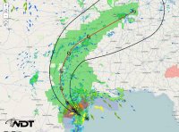
Tropical Storm Bill makes landfall

Joined
Mar 7, 2015
Messages
45
Location
Aberdeen, Maryland
As of 10 AM Tropical storm Bill has made landfall near Galvaston. I wanted to start this thread so that others could discuss their thoughts on Tropical Storm Bill. (This is the first thread that I have ever made, so I hope it's ok.)

My thoughts? The rain has already started to fall here, and the main threat for the next few days is flooding. (Isolated Tornadoes and strong thunderstorms are possible as well.)
 
As Dr. Jeff Masters pointed out in his blog post yesterday, this could be one of those Allison-type storms that brings epic rains to parts of the southern US. A slow moving and weak TC in the Gulf with weak to almost no steering current and a moisture plume that is at the top of the charts figuratively and climatologically (see SPC raob climatology page to see for yourself at http://www.spc.noaa.gov/exper/soundingclimo/) for many soundiing sites in the south-central US is kind of a recipe for epic flooding somewhere. It may not be widespread flooding, but someone is probably going to get an impressive (even for record territory) rainfall out of this. The 12Z SSEO ensemble mean contains a 9"+ 24-hr precip maximum just southwest of Houston, although precip amounts drop off quickly away from that point to a "modest" 2-3 inches across much of C and E TX through tomorrow morning. The 15Z HRRR shows a strip of 6"+ falling between 15Z and about midnight CDT in a similar area. It also shows the "brown ocean" effect at work, as it depicts a decrease in minimum central pressure of 2-4 mb between now and 06Z tonight, after the center is well inland. However, later runs reduce or eliminate this effect. I'm not seeing in the RAP either. 4 km NAM plots are too hard to read to tell if any of that is going on . The 12Z NSSL WRF does show some minor strengthening as far north as the Red River.

Bill will post a major flooding threat along most of its track across the US, including Oklahoma later on tonight and tomorrow. The big question around here is what exact path will the center follow and what will be the shape of the rain shield associated with it? Models have been pretty consistent on keeping the heaviest precip along the northern and eastern quadrants with a sharp gradient in precip amounts to the west. I would tend to agree with that given current radar trends. It means someone is going to get flooded pretty bad, and someone 50 miles west is only going to get a decent summery rain shower.
 
1434498960573

The GFS wants to sink NC and NE Okla, including OKC/Tulsa. Also note it's total disregard for the already overflowing Texoma Lake - a secondary bullseye is over it.

1434499000525

And the NAM would like to see NE TX underwater and spares major Oklahoma metros. How about that 16.76'er down in SC TX?

panel_c_8.png

Get a load of the wind-speed potential off this once it gets up to Oklahoma (upper left). Also, plenty of water as is indicated in frames upper and lower right. Finally pressure in the lower left tells you your knee will be sore Thursday night.
 
Watch Bill's remains closely. Strong, bandy peripheral convection during the day, but it is the overnight that can get really sneaky. This is regardless of whether or not Bill has the "brown ocean effect" (Google it, its the new wx buzz hype word it apparently!). in fact, despite steady weakening of the sfc center in such an tropical environment with flat, moist land, the 850/700 center can maintain very well for a long time. Back to the sneaky overnight, sometimes this blob of relatively low DBz pcpn forms near the mid level center, and it absolutely unloads with torrential rains, and not always impressive on sat as it often is warm topped convection.
 
As of 11:00 AM, Tropical Storm Bill is now a Tropical depression, and is nearing Oklahoma now. (Near the Dallas area at the moment.) Flooding is still a main threat.

Watch Bill's remains closely. Strong, bandy peripheral convection during the day, but it is the overnight that can get really sneaky. This is regardless of whether or not Bill has the "brown ocean effect" (Google it, its the new wx buzz hype word it apparently!). in fact, despite steady weakening of the sfc center in such an tropical environment with flat, moist land, the 850/700 center can maintain very well for a long time. Back to the sneaky overnight, sometimes this blob of relatively low DBz pcpn forms near the mid level center, and it absolutely unloads with torrential rains, and not always impressive on sat as it often is warm topped convection.

Just googled the Brown Ocean effect. I never knew what it was until today. The only place I ever heard about the Brown Ocean effect was here.
 
I just woke up and looked at the radar. I was thinking the center of circulation would be more over Dallas or slightly east, but it's west of Fort Worth right now. That doesn't bode well for OKC or the I-44 corridor headed towards Tulsa.

Purcell is already getting rained on and I expect the main swath of precip spread into OKC proper by mid evening.
 
This "brown ocean" effect brings with it some interesting theories regarding landfalling tropical cyclones. The most interesting to me, is whether or not, with the absolute perfect conditions, could a tropical cyclone traveling in the same trajectory such a Bill but at a higher intensity ( Cat 1 or better) maintain the status well inland.
 
Looks like it's taken a slight wobble back to the left. The north and west sides of the Metro haven't had much rain to speak of, but if keeps drifting back to the west, watch out.

Tulsa is bracing as well. EMs there are expecting Bird Creek (which passes just north of my hometown of Catoosa) to flood, something it hasn't done in several years. I would not be shocked if they halted barge traffic to and from the Port of Catoosa again like they did late last month.
 
Watching the radar loop right now, I'm not sure that it has any forward motion at this point. That doesn't bode well for the south and east side of the OKC Metro or anything along or near the Turner Turnpike.
 
Back
Top