-
While Stormtrack has discontinued its hosting of SpotterNetwork support on the forums, keep in mind that support for SpotterNetwork issues is available by emailing [email protected].
You are using an out of date browser. It may not display this or other websites correctly.
You should upgrade or use an alternative browser.
You should upgrade or use an alternative browser.
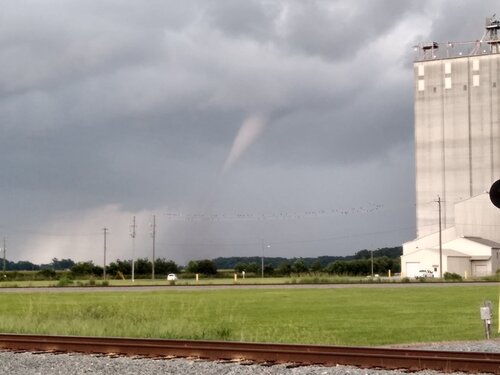
Tornado or Landspout
- Thread starter Don Brown
- Start date
rdale
EF5
Devin Pitts
EF2
Looks like a tornado for sure given the debris cloud. Based on surface obs from Monday it looks like there was a stationary front draped over that area along with weak flow aloft, so I'd assume landspout.
Paul Knightley
EF5
It's a tornado! Of course, tornadoes can develop from low-level mesocyclones, or not, but it's a tornado by the (current) definition of a tornado whether from a mesocyclone or not.
adlyons
EF2
Landspout or not it's still a tornado. "A violently rotating column of air in contact with the cloud and the ground."
rdale
EF5
If it's touching the ground it's a tornado. Given the lack of debris here, and the lack of any damage indicated on the ground, whatever it is - isn't a tornado.
Jeremy Perez
Supporter
Wow, sure looks like a debris cloud under that funnel to me. @Don Brown I adjusted the shot for contrast to make it clearer...would you be okay if I posted that?
Paul Knightley
EF5
Wow, sure looks like a debris cloud under that funnel to me. @Don Brown I adjusted the shot for contrast to make it clearer...would you be okay if I posted that?
I agree - I can see a debris cloud too.
rdale
EF5
I'd have to see video to be convinced - but in any event, no damage was detected on the ground and if no damage occurred I'd have a hard time calling that debris from non-existing damage 
Paul Knightley
EF5
..unless it's just dust being lofted! 
Paul Knightley
EF5
I think this is the same storm - Possible Tornado Spotted Near Mount Olive (PHOTOS)
One of the images shows a dust cloud lower down the funnel.

One of the images shows a dust cloud lower down the funnel.

Matthew Crowther
EF4
The title of this thread needs to be changed. A landspout IS a tornado. Period. This should read "Landspout or mesocyclonic tornado?"
Paul Knightley
EF5
...or 'Non-mesocyclone or mesocyclone tornado?' - let's get rid of 'landspout'! 
rdale
EF5
There were quite a few years when landspouts were not 
https://journals.ametsoc.org/doi/full/10.1175/WAF-D-14-00058.1
https://journals.ametsoc.org/doi/full/10.1175/WAF-D-14-00058.1
Paul Knightley
EF5
Ah, good times!
Similar threads
- Replies
- 2
- Views
- 720
- Replies
- 1
- Views
- 1K
- Replies
- 7
- Views
- 4K
- Replies
- 13
- Views
- 2K

