• After witnessing the continued decrease of involvement in the SpotterNetwork staff in serving SN members with troubleshooting issues recently, I have unilaterally decided to terminate the relationship between SpotterNetwork's support and Stormtrack. I have witnessed multiple users unable to receive support weeks after initiating help threads on the forum. I find this lack of response from SpotterNetwork officials disappointing and a failure to hold up their end of the agreement that was made years ago, before I took over management of this site. In my opinion, having Stormtrack users sit and wait for so long to receive help on SpotterNetwork issues on the Stormtrack forums reflects poorly not only on SpotterNetwork, but on Stormtrack and (by association) me as well. Since the issue has not been satisfactorily addressed, I no longer wish for the Stormtrack forum to be associated with SpotterNetwork.

    I apologize to those who continue to have issues with the service and continue to see their issues left unaddressed. Please understand that the connection between ST and SN was put in place long before I had any say over it. But now that I am the "captain of this ship," it is within my right (nay, duty) to make adjustments as I see necessary. Ending this relationship is such an adjustment.

    For those who continue to need help, I recommend navigating a web browswer to SpotterNetwork's About page, and seeking the individuals listed on that page for all further inquiries about SpotterNetwork.

    From this moment forward, the SpotterNetwork sub-forum has been hidden/deleted and there will be no assurance that any SpotterNetwork issues brought up in any of Stormtrack's other sub-forums will be addressed. Do not rely on Stormtrack for help with SpotterNetwork issues.

    Sincerely, Jeff D.

Tornado in Iraq, 14th April 2016

Joined
Feb 6, 2006
Messages
975
Location
Reading, England
A number of videos have emerged showing a tornado in Maysan, SE Iraq, yesterday (April 14th).

Rather impressive!


https://www.facebook.com/amin.a.altaher/posts/1303521392994576?fref=nf&pnref=story

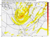
Looks like a warm/moist from the Persian Gulf (18/19C dewpoints) spread north-westwards in advance of an approaching upper trough. 500mb flow was around 50 knots from the SW (all this is from yesteday's 00Z ECMWF as there isn't a great deal of obs data in the area). MUCAPE was progged around 2000J/Kg, so a supercell environment was in place.

As an aside (and perhaps worthy of a different thread) the next week looks very favourable for severe weather in the Ganges-Brahmaputra Delta region (Bangladesh and portions of India) - over 6000J/Kg of CAPE progged at times with surface dewpoints of 27C/81F under strong 500 hPa flow.
 
Very impressive tornado!! A couple of tornadoes too over on the Iranian side. Here are a few modelled charts from the 14th (though taking the 12Z ones may be a bit late). Nice approaching strong upper trough into east Iraq / west Iran with surface low over northeastern Saudi Arabia.

Impressive showalter indices to -7C, MLCAPE to 2500j/kg, rich moisture transported out of the Persian Gulf deep into northern Iraq, and very agreeable wind profiles meant a good couple days of supercells!

Observed 14/00Z sounding (3AM local time) out of Ahvaz, far SW Iran... 160km SE of tornado location in Amarah, SE Iraq indicated a potent setup for the region:
http://weather.uwyo.edu/upperair/bimages/2016041312.40811.skewt.parc.gif
 

Attachments

  • gfs-show--iraq2-00-C-show1_white[1].png
    gfs-show--iraq2-00-C-show1_white[1].png
    57.4 KB · Views: 165
  • gfs-ehi--iraq2-00-C-ehi1801_white[1].png
    gfs-ehi--iraq2-00-C-ehi1801_white[1].png
    28.3 KB · Views: 160
  • gfs---iraq2-00-C-shear0-3km_white[1].png
    gfs---iraq2-00-C-shear0-3km_white[1].png
    91.2 KB · Views: 156
  • 12993331_10153383356446401_7276844983162971082_n.jpg
    12993331_10153383356446401_7276844983162971082_n.jpg
    188.3 KB · Views: 156
  • 12994387_10153383365586401_9182400096261713239_n.jpg
    12994387_10153383365586401_9182400096261713239_n.jpg
    160.6 KB · Views: 155
  • gfs---iraq2-00-C-jetwind_white[1].png
    gfs---iraq2-00-C-jetwind_white[1].png
    70.2 KB · Views: 151
Last edited:
In one of the videos, there were two similar tornadoes ongoing simultaneously. It looked like a 5/19/12 type non-supercell tornado event (high based storms sitting on a low-level convergence boundary). I wonder if they have radar there?
 
In one of the videos, there were two similar tornadoes ongoing simultaneously. It looked like a 5/19/12 type non-supercell tornado event (high based storms sitting on a low-level convergence boundary). I wonder if they have radar there?
I bet you a lot of nickels that they have radar to identify aircraft. Oh, you mean weather radar? Ha.
 
There was one tornado in Dolores, Uruguay yesterday. Unfortunately 4 people were killed and 2 kids were airlifted to a hospital in Montevideo. It was rated F2.

I had a secretary from Uruguay years ago, and she told me that Uruguay gets quite a few tornadoes every year. I found that hard to believe, thinking she probably was referring to dust devils or waterspouts....but in recent years, she has proven herself to be correct. Good job, Helena....you fox, you.
 
I had a secretary from Uruguay years ago, and she told me that Uruguay gets quite a few tornadoes every year. I found that hard to believe, thinking she probably was referring to dust devils or waterspouts....but in recent years, she has proven herself to be correct. Good job, Helena....you fox, you.


Well, there is an area in Argentina and Uruguay called the Pampas, a flat area much like our Plains that does get frequent winter thunderstorms. The term "gaucho" originates in this area as cowboys once roamed this area.


Another major tornado outbreak happened on April 14th, 1993 called "tragic tuesday" where 300 tornadoes touched down. Buenos Aires get tornadoes every few years actually.
 
Back
Top