Tornado Height ABOVE Ceiling

Joined
Jun 4, 2011
Messages
15
Hey All,

This is my first post on the site.I had been deep into meteorology when I was younger, but have been largely out of the wx loop for the last 25 years.So I am getting back into to groove and trying to learn what's been discovered more recently.

I was wondering about tornado height above the cumulonimbus ceiling,especially for the larger boys at EF-3 or EF-4.

Maybe someone could provide a basic primer on the flow field involved (other than the basic overall MESO scale cyclonic rotation of the the CB itself).I know that there are other factors involved like (rear flank?) downdraft and inflow updrafts (other than a ,on my part perceived, possible gradual corkscrew upflow of the entire outer portion of the CB itself).

My grasp of the latest tornadic theory is weak ( at an EF- 1, ha, ha).So any help in in explanation as a "Tornado Flow Dynamics 101" is appreciated.

I am fairly sure that (upper EF) tornadoes generally form at the edge of the CB and NOT at the axial point of the mesocyclone. Therefore I would THINK that the actual tornadic rotation would eventually lose it's definition during its journey upward and get "washed out" into the larger mesocyclonic impetus or other interior flow structures. I can't see a full rotation being maintained ALL the way up to top of the CB,but maybe to around half way up (20,000 ft ?? ).

This runs counter to a photo provided by a meteorology teacher I had seen many years ago while I was in the USAF .It shows a small but very clear EYE when looking down onto a CB top ( the eye was similar to a hurricane's) . I'm unsure whether it was taken by a very high altitude recon aircraft or by satellite.The eye was supposedly being caused by a major tornado on the ground.I would like comments as to whether this could ever occur or whether this photo was somehow in error.

As gee whiz, I had been a 10 year volunteer at the NWS Blue Hill Climate Research Station, Milton ,MA and have taken a few basic wx courses years ago. I am also a private pilot and FWIW once saw a good display of a funnel while flying.

Any input or help is greatly appreciated,Thanks,

Kevin Norton
 
I was hoping somebody more knowledgeable could chime in here. I saw during a lecture, maybe it was Chasercon, and I believe it was DOW radar data, where they had analyzed the vertical wind profile of a tornado. The vortex did not extend much past the cloud/updraft base into the parent cyclone (a small fraction of the vortex's total height was above the cloud base) and above that the wind fields quickly diffused into the parent circulation's. It certainly did not go all the way to the top of the updraft tower with an eye in the overshooting top, or even a significant portion of the way into the updraft tower. From what I've gathered these are bottom-up processes, with most of the energy concentrated at the bottom rather than the top. The strongest winds are probably right near the ground level (making exceptions for the effects of friction). Look at suction vortices as an example. They are most intense right near the ground and quickly diffuse into the parent tornado, often well below the top of the visible condensation funnel. The suction vortices' parent circulation, the tornado, probably follows a similar pattern, with the most intense part of the circulation focused at the bottom, and diffusing quickly where it meets its parent.

I'd love to see that photo with the eye in the top of the updraft tower if you ever find it though. Something like that sounds absolutely incredible, if it does indeed exist.
 
My area of interest is primarily in radar polarimetry, and I haven't looked that much into velocity fields in terms of the vertical characteristics of tornadoes. I do know that the couplet and weak echo hole associated with the Greensburg tornado extended nearly to storm top, however. My old officemate ("old" as in she's no longer in my office, not "old" as in she's old ;) ) used our UMass XPol data of the Greensburg supercell as the focus of her dissertation, so she can provide more details is she'd like.

The strongest quasi-horizontal winds / radial velocities we recorded with RaXPol on 5/24 W of El Reno were on the lowest couple of scans, decreasing with height. We didn't scan high enough to top the storm, though. I strongly suspect that the height at which it becomes difficult to discern the tornado in velocity data is quite variable, both during the lifecycle of individual tornadoes and from one tornado to the next. Certainly, there's a difference between a short-lived EF0 and a long-lived, violent tornado, and that's only including tornadoes produced by mesocyclones. I also suspect that landspouts and QLCS tornadoes tend to be relatively shallow compared to mesosclone-associated tornadoes in supercells, but, again, this isn't really an area in which I'm very knowledgeable.

Edit: Talking with Mike French, a fellow PhD student in my office, he sees tornadoes extend >4 km in height in several of the MWR05XP datasets (5/24/11, 6/5/09, etc.). Again, these are primarily long-lived, strong tornadoes, but we have a relatively limited sample size.
 
Last edited by a moderator:
Hey All,

I certainly bow to anyone's knowledge over mine.

One thing still "bothers" me though - debris "tossing". During the '53 Worcester ,MA tornado we had a door from a large walk in meat locked (hundreds of pounds ?) fall onto Blue Hill, Milton, MA very near the weather observatory.

Even if the vortex is intact as high as 10,00 ft it seems hard to believe that the rotation of the mesocyclone itself or any interior updraft (even ,say 100 mph) could support, carry or throw such a heavy object some 45 mi downrange.French text books (admittedly much light) were found another 6 mi or so further East from Blue Hill.

One would THINK that at least the door would have "precipitated out " LONG before traveling such a long distance.

I am sure similar examples also exist from other parts of the country.

Anybody ?

Kevin Norton N1NQC
 
Last edited by a moderator:
I am very cautious to present my limited knowledge here.. We chased last year, July 23 in SD starting in Murdo and intercepted the storm that went on to produce the record hail near Vivian, SD. If I recall, the mets that reviewed that storm said that they estimated the updraft speed at something along the lines of 250 mph. If storm updraft can, and routinely does get that violent in a tornadic cell, I see no problem in carrying a very non-aerodynamic object a long distance. It would certainly take MUCH less wind to keep that door in the air than 8 inch hail stones, despite the weight difference. Try running with a 4x8 sheet of plywood, then try running with a big workout ball. Similar in weight, but the resistence is night and day.

Thoughts?
 
Hey Will,

This now starts to get fuzzy for me.Per the above posts, the CYCLONIC aspect of the tornado seems to lose it's definition "fairly soon" (<10,000 ft ?) .But the supposition here is that although the CIRCULATION aspect is lost, the SPEED of the updraft ( which, seemingly in your view, has morphed into non rotating up moving "cylinder" or helix of air(?)) remains quite pronounced and is well above the "expected" speed of a severe NON tornadic storm ( which by my GUESS may have updrafts of , say,100 to 125 mph ???).

I think there is much to clarify re the interior of a tornadic storm vs a non tornadic one.

Obviously the Worcester Tornado did what it did (somehow). The tornado itself had lifted/dissipated some 25 mi or so West of Blue Hill. My GUESS of the throw arc for such a heavy piece of debris would have a ground foot print at least 30 mi long (maybe even as much as 45 mi !) possibly or probably lobbed all the way to the CB top (60,000 or 65, 000 ft ??). The action seems very similar to an artillery round fired out of a cannon( tornado) , arcing nicely and then crashing to Earth.

Kevin Norton N1NQC
 
Last edited by a moderator:
Kevin, I would suggest looking at some Skew-T/Log-P plots for soundings that have a lot of instability (i.e., just about any sounding in the central US during the summer...today would be particularly good). By parcel theory, an air parcel will accelerate upward as long as its density (or temperature) is less than that of the environment (warmer than the environment for temperature). This is the same thing as saying the parcel is "positively buoyant" or that the parcel path is to the right of the environmental temperature profile. For a parcel with > 0 CAPE, this means the parcel will accelerate vertically all the way up to its level of neutral stability, also known as the equilibrium level, which is usually in the 250 - 150 mb range during the warm season for very unstable soundings. Ignoring some effects not covered by parcel theory, this means that the maximum updraft speed will occur near the cloud top, or at the equilibrium level. That's why the updraft will maintain its character to a much greater height than the tornadic circulation. You can also estimate this maximum speed using the formula "max updraft speed = sqrt(2*CAPE)". That value is probably never achieved, however, because the assumption used to derive that formula is that ALL of the CAPE is directly converted to kinetic energy, which of course it isn't due to water loading of precip, entrainment, and friction. I think you'd be safe in assuming that the actual maximum updraft speed is at least 50% of the theoretical value, though.
 
Last edited by a moderator:
Obviously the Worcester Tornado did what it did (somehow). The tornado itself had lifted/dissipated some 25 mi or so West of Blue Hill. My GUESS of the throw arc for such a heavy piece of debris would have a ground foot print at least 30 mi long (maybe even as much as 45 mi !) possibly or probably lobbed all the way to the CB top (60,000 or 65, 000 ft ??). The action seems very similar to an artillery round fired out of a cannon( tornado) , arcing nicely and then crashing to Earth.

Kevin Norton N1NQC

Don't forget the mid-level jet. The kind of distance you're talking about for such a heavy object is likely only partially a product of momentum, height, and trajectory. I don't know how strong the H5 jet was that day, but given that the same system produced the Flint-Beecher F5 tornado the previous day, followed by the Worcester F4 on the day in question, it had to have been substantial, conceivably as much as 80 knots or more. You've got a flat object with considerable surface area carried aloft by a tornado into strong horizontal winds and sustained there by powerful updrafts until its weight finally drags it gradually down out of their influence and it arcs earthward. That seems to me the likeliest explanation.
 
You've got a flat object with considerable surface area carried aloft by a tornado into strong horizontal winds and sustained there by powerful updrafts until its weight finally drags it gradually down out of their influence and it arcs earthward. That seems to me the likeliest explanation.

Science fiction is boring!

While I agree that most smaller tornadoes most likely get washed out not too far up the profile, however... I have this image of the Bowdle, SD storm of last year... to me this picture shows a supercell being steered/dictated by a MASSIVE tornadic circulation that likely extends to the top of a DEEP mesocyclone. It makes perfect sense that the best tell-tale hint of a VERY tall tornado is the rare and magnificent 20 minute rope-out which accompanies significant tornadoes the majority of the time. The extreme example of this being the Crazy farmer Columbus, NE tornado. Just a difficult thing to comprehend when tornadoes get smaller and less intense... but easy to believe when you've got this in front of you!
attachment.php


attachment.php


And just to mix it up, same frigging storm, with a more visually impressive mesocyclone... but much lesser of a tornado.

attachment.php


Thoughts?
 
Last edited by a moderator:
Jeff, It's been MANY,MANY years since I looked at a Skew T,but it's something I could look into.

Bob, interesting input re the mid level jet.

Terrance, AWESOME photos and good observations in your text.


Overall I don't think we have completely "settled" the issue and may not ever, due to possible variability from storm to storm and different interpretations by observers. But I HAVE learned some things here so far.

Kevin Norton N1NQC
 
I too have wondered just how high the tornadic circulation can get. Snyders tidbit about the Greensburg tornado is interesting.

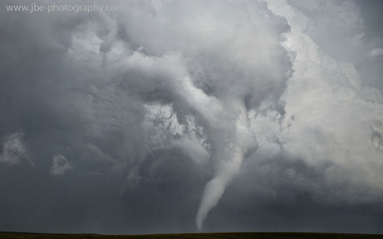
Check out this recent picture from my last chase of the Pleasanton, NE tornado from 6-20 taken by Jen Brindley. The most fascinating part is how high the tube actually goes. Depending on your position on the storm though you wouldn't see it all as we were actually SW of the tornado looking NE at it. For the few on the other side it appeared as a more slender/traditional looking cone as opposed to this weird bent trunky...thing.

JBE_0349JennEdited+copy.jpg
 
Back
Top