Storm intensity decreasing after crossing the Mississippi

  • Thread starter Thread starter Drew.Gardonia
  • Start date Start date

Drew.Gardonia

I've noticed every set of storms we've had here in Tennessee have gone linear (squall line) after crossing the Mississippi River. anyone have any thoughts on this as to why? Our first set of storms rolled through on 2-23-2011. A friend in Memphis said there was intense CG lightning all over the place. when the storms reached Nashville, there was hardly any lightning at all, and we did have sirens and 2 confirmed tornadoes in the area, but it seemed like the storms lost a lot of their intensity after crossing the Mississippi and working their way east towards Nashville. None of the storms that we have had here in Mid TN have produced very much lightning either which is really strange. I'd like to hear some thoughts and opinions as to why these storms on why they are going linear, why they aren't as intense after the cross the Mississippi and why they aren't producing a lot of lightning.
 
This is pretty funny, we're scratching our heads and thinking the same thing up here in Wisconsin, and there is endless anecdotal evidence of storms weakening as they traverse the region near the mississippi.

It is best to eliminate the easiest possibilities first.
One, in the synoptic scale, did the storms encounter an air mass that was less favorable to upward motions/surface based convection each time?
Two, did areas to your north or south or even east experience severe weather?

Severe weather, especially tornadoes, impact a relatively small area. For example, I know there has been discussion about the SPC forecasting a high risk for North Carolina.. and there definitely was a spot within that high risk that didn't experience anything! What someone would have experienced if they drove 30 miles from that spot in any direction, however, is a different story! Even within a tornado warning.. the area covered by the warning is much larger than the actual tornado itself, if there even is a tornado on the ground at any given time.

Another thing is the ambiguous term "intensity." Are you talking about the rain? The reflectivity? The velocity couplets? Downdraft strength? CG lightning? As storms move from radar to radar, elevation to elevation, etc.. the remote sensing representation that you see can change depending on what portion of the thunderstorm the radar signal is "cutting" through. The pesky curvature of the earth hurts us in that regard but helps to spin up the synoptic scale storms that spawn such weather.. pick your poison!
 
Last edited by a moderator:
Every weatherwatcher in the world thinks that storms (insert one of the following: get weaker when they approach, split and miss, die and redevelop past ) my location.
 
There's some truth to what rdale said, but there's some science behind it too - although probably not in the way you're thinking.

Look at where the EML comes from, where the dryline exists, where different air masses originate and travel. There's nothing about the river itself, it's just that the perfect combination of ingredients come together on the lee-side of the Rockies, and eventually as you progress eastward that 'zone' degrades into areas less favorable for sustained supercells that drop massive hail and tornadoes.
 
This is pretty funny, we're scratching our heads and thinking the same thing up here in Wisconsin, and there is endless anecdotal evidence of storms weakening as they traverse the region near the mississippi.

It is best to eliminate the easiest possibilities first.
One, in the synoptic scale, did the storms encounter an air mass that was less favorable to upward motions/surface based convection each time?
Two, did areas to your north or south or even east experience severe weather?

couldn't answer the first one, but the 2nd one yes...most of the storms that have moved through here, have all been much stronger, intense and violent to our immediate south (nrn AL, MS, GA) areas.


Another thing is the ambiguous term "intensity." Are you talking about the rain? The reflectivity? The velocity couplets? Downdraft strength? CG lightning? As storms move from radar to radar, elevation to elevation, etc.. the remote sensing representation that you see can change depending on what portion of the thunderstorm the radar signal is "cutting" through. The pesky curvature of the earth hurts us in that regard but helps to spin up the synoptic scale storms that spawn such weather.. pick your poison!

for the Feb 23th squall line that moved through

well when I say intense, the storms seemed to fall apart on the GRLEVEL3 in intensity, and they weren't as tightly grouped together in the squall line after leaving the Memphis area and reaching the Nashville area which is a distance of about 160-180 miles.

the rain and wind were very intense in that storm, but there was almost no lighting that night, yet when the same storms his Memphis, there were multiple flashes per second there according to a friend who lived there.


pretty much the same thing has happened with every line of storms that's moved through since.

although tonight we had some scattered showers that actually produced some good lightning for the first time this year, but alas, I was in church at the time....:mad: go figure.
 
There is some effect from the diurnal cycle, that is, the daily instability maximum/minimum. Day 1 storms tend to initiate in the afternoon on the dryline east of the Rockies, reaching within 100-200 miles of the Mississippi River the next morning. The storms have generally weakened by then due to the time of day when instability is at a minimum. The day 2 convection then fires east of there in the afternoon as the system (upper support, cold front, surface low, etc) moves east, reaching the Appalachians at the end of day 2. The Appalachians cut off southerly inflow and low-level moisture advection, resulting in a second minimum in the vicinity of the mountains that is less dependent on timing. Then day 3 storms typically fire on the eastern foothills/Piedmont, and move offshore by evening.

Lightning data shows a noticeable minimum in strike densities per square mile in central Missouri, which would correlate well with day 1 Plains dryline convection dying out during the overnight hours, then refiring along/east of the river by afternoon.

Of course, there is no hard and fast line that can be drawn where this day 1 to day 2 minimum will occur. It all depends on storm motion/speed, degree of eastward position of the dryline, cold front speed, etc. A dryline firing on the NM/TX border could result in a minimum storm intensity in eastern OK, with refiring in central MO the next day. A dryline firing in Tulsa might result in storms dying out in Indiana, re-initiating in Ohio.

Rob is right, perception plays a role. There were patterns when I lived in West Virginia when I saw daily strong storms for a month. Living in St. Louis, I see a tendency for day 1 Plains systems to arrive in the morning in a dissipating stage, but it's definitely not the rule. When the Plains dryline is farther west, our day 2 storms come through during peak heating and can be quite good.

Chasing tends to remove any localized perceptions. For a stationary observer, many strong storms will invariably pass more than 50 miles north or south, resulting in the appearance of rarely getting good storms. Just driving 50 to 100 miles from home on convective risk days can more than triple the number of strong storms observed.
 
Having grown up in Paducah, KY; I know that it seems VERY COMMON that strong to tornadic storms will form in SE Missouri or southern Illinois; and once they encounter the Ohio or Mississippi rivers, they always seem to "fall apart." Only once reaching west-central Kentucky (Hopkinsville on east) do they reintensify.

This isn't always the case. But officially, I do not recall a confirmed tornado hitting the city limits of Paducah in all my years of living. Funnel clouds sighted, surrounding cities like Benton, Murray, etc. yes. Also seems like Ballard County, KY catches a lot of the intensity of storms crossing over the river(s.) But yes; something about that "river effect" just inevitably kills the storms and even a good squall line will often times break apart.

Perhaps a 'negative' orographical effect... due to the large river valleys and localized surface cooling due the mass of all the coverage of water ??? Eh... just a thought. Lots of rivers converge in that area... Cumberland, Tennessee, Ohio, Mississippi, coupled with LBL (Land Between the Lakes.) But very amazing how those rivers seem to destroy any intense convective structure!
 
I have noticed a similar effect on storms as they come closer to Houston. They go just to the north or the south and strengthen while in the downtown vicinity they weaken. Strange stuff
 
Every weatherwatcher in the world thinks that storms (insert one of the following: get weaker when they approach, split and miss, die and redevelop past ) my location.

Exactly. I've seen this thought process repeated a million times over. Pick any one location and you'll receive the same "frustrating" results. (because no one location is going to consistently experience weather at the pinnacle of its severity... which is what we seem to be looking for in a relative sense)
 
Yes yes, this is a very common phenomenon. Even in Oklahoma, where we have the highest density of high-end severe weather in the world, people in certain localities are convinced that they are within a bubble. The Norman "bubble" for instance was essentially shattered last May when two EF4 tornadoes ripped through the Northern and Southern city limits. Having grown up in Tulsa, many people are convinced that either Turkey Mountain, the Arkansas River or "indian burial grounds" protect Tulsa from Tornados. This is hilarious because I recall seeing a list from the SPC a few years ago ranking the Nation's most "long-track" violent tornado-prone cities due to climatalogical data and Tulsa was number 1. So really, it's just the nature of severe weather. If violent tornadoes hit American cities in the plains on even a once-a-decade basis, people probably wouldn't inhabit the American midewest/south/plains in the density they do now. For that matter, architecture more than 50 years old wouldn't even exist, and as we all know there are some very old historical buildings in great condition in some of the regions oldest cities.
 
A friend in Memphis said there was intense CG lightning all over the place. when the storms reached Nashville, there was hardly any lightning at all, and we did have sirens and 2 confirmed tornadoes in the area, but it seemed like the storms lost a lot of their intensity after crossing the Mississippi and working their way east towards Nashville. None of the storms that we have had here in Mid TN have produced very much lightning either which is really strange.

Lol. Your friend is DEFINITELY DISINFORMING YOU. I live in Memphis but last time I went to Nashville, there was plenty of lightning. The last time Memphis got a confirmed tornado was like ONE HUNDRED years ago. Squall lines are a PRICELESS RARITY. We get ONE cumulonimbus cloud every THREE months, and you’re complaining that Nashville doesn’t get enough storms and lightning!

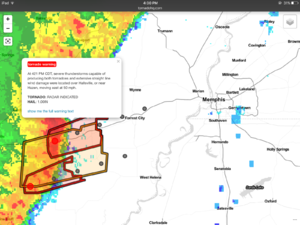
The image below shows a very well organized squall line to the west of the Mississippi River. Tornado warnings and bow echos were everywhere, but once it crossed the river, it immediately started weakening. By the time it got to Collierville (20 miles east of Memphis), there were no warnings or watches. Not even a severe t-storm watch was issued.

Donald Trump said:

GETTING SERIOUS: The west Tennessee highlands drop down into the Nashville Basin, and that might affect squall lines. What I’m thinking is that the Cumberland Plateau is affecting air circulations and it stops squall lines from forming in Nashville as well. Have you all ever noticed that once squall lines hit the Appalachian Mountains, they rapidly weaken. Once they pass they rapidly strengthen into North Carolina, and that might be why there are more tornadoes in the Carolinas, the Virginias, Mississippi, and Georgia than Tennessee. I think it’s more of a terrain than a river phenomenon. Rivers just aren’t wide enough to affect t-storms.

Having grown up in Tulsa, many people are convinced that either Turkey Mountain, the Arkansas River or "indian burial grounds" protect Tulsa from Tornados. This is hilarious because I recall seeing a list from the SPC a few years ago ranking the Nation's most "long-track" violent tornado-prone cities due to climatalogical data and Tulsa was number 1.

The entire state of Tennessee is a bubble.

962E4BE6-9129-41C6-B4C4-85955656E9B3.png
 
Last edited:
Back
Top