• While Stormtrack has discontinued its hosting of SpotterNetwork support on the forums, keep in mind that support for SpotterNetwork issues is available by emailing [email protected].

Questions about a UK severe storm

Joined
Mar 11, 2016
Messages
13
Location
England
Hi everyone,

Last year in the UK, on July 1st we experienced a "Spanish Plume" scenario involving record high temperatures and some severe thunderstorms which broke out in the of England in particular.

In the early stages of the storm, as I watched it, it seemed like a multicell complex but is it possible that a cell within the complex could become a supercell?

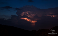
The reason I ask is because about 11:00PM one apparently produced 2 inch hailstones and I found a picture of it at about that time, lit up by lighting looking like it could show features of possible supercell structure. I have attached some videos and the picture I'm talking about.

And also it seems odd in the first video that the smaller cell is producing almost all the lightning and not the bigger one to the right.

All the vids/pics are of the same storm which was seen for miles around.

Video 1:

Video 2:

Picture of the cell close up at about 11:30PM.
1007645746143b51d0f291c39a180bc4.png

Do you think this cell could have the visual indicators of a supercell?
 
When you say "visual indications of a supercell" where are you exactly seeing those indications? Remember that a supercell would show signs of rotation - and to be honest I'm not seeing that.
 
Well in the final picture, I guess it's not the best lighting, but looking at the updraft area the structure seems similar to what I've seen in supercell storm pictures. This pic is from around the time large hail was reported but that doesn't mean it was a supercell of course. In this country only the met office has doppler radar to prove if it was or not but they don't make this publically available.
 
Ah - I see. Could be a good structure, but without seeing rotation (visually or from radar) it's hard to call it a supercell. Still a nice storm and great pics!
 
Apologies for reviving an old thread, but it's largely because until now I hadn't found any more analysis or information about this storm.

However, a week ago while researching the severe storms of July 1st 2015 I came across a technical analysis of the storms of that day, but it is behind a paywall.

http://onlinelibrary.wiley.com/doi/10.1002/wea.2837/abstract

The southern most cell (which is the one visible in the opening post video, shot from the southeast) was indeed a confirmed supercell. The cell was tracked on dual doppler radar due to its history of producing severe hailstorms causing damage, and there are a few radar images of it taken at 22:51, showing a defined hook echo and opposing winds in the south east inflow area directly in the area of the hook echo.

I also found an excellent video (below) recorded by somebody 40 miles south east of the storm showing what I believe is the supercell developing (left in the video) as a daughter cell of a multicell complex (to the right in the video). Between 2:00-5:00 minutes into the video it makes a rapid vertical development, and at 6:45 minutes in the video, corresponds with 22:51BST when the hook echo becomes defined in the radar picture. Unlike the cells before it this one also does not spawn new cells to its rear, but new vertical developments appear to merge into the cell's updraft if you look closely. Unfortunately as it spreads into a large anvil it is hard to see due to the night time conditions.


About 10-15 minutes after this the first large hail reports started to appear. The storm was a very rare occurrence for the UK and the fact it had no clouds obscuring it meant people had a good view of a rare developing supercell storm for miles around. I expect this would be a rather more common sight in the US, of course.
 
Hi Richard from a fellow UK chaser!

I missed this thread first time around. This was very likely a supercell - as you say, it produced some large hail along a fairly long path.

We at TORRO had a watch out for severe weather that evening, which included the risk for large hail from supercell thunderstorms.

So, yes, it was very likely a supercell.
 
Back
Top