Questionable structure

Joined
Jan 18, 2015
Messages
232
Location
Tucson, AZ
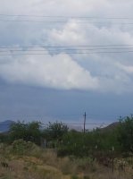
I went on my first legitimate chase Tuesday (06-09-2015), nothing special, just remnants of Blanca. Got some decent "storm" structure, especially considering they weren't much of anything other than some rain, low cloud tops, high bases and microbursts. Not even a bit of lightning.
As I was coming into Oro Valley from the west looking east, I saw an eerie bit of structure about 10 miles to my east on a cell sitting over Mammoth. Hard to tell because of distance and lack of good contrast, and even harder to tell in a picture (taken with my samsung). I'd like to see what other people think about this.

It kind of looks like a wall cloud. You can see a base, and a definite lowering off of it. The thing that makes me question it, other than not being able to verify since being so far away is the way it's tilted because the rain shaft would have been to the left of the image, however it also had the terrain underneath giving it that tilt as you can also see it on the base

Sorry if it's hard to see
I'm interested in seeing what other people's thoughts are on this..thought it'd be a good topic to share =]
 

Attachments

  • wall cloud.jpg
    wall cloud.jpg
    22.5 KB · Views: 204
I went on my first legitimate chase Tuesday (06-09-2015), nothing special, just remnants of Blanca. Got some decent "storm" structure, especially considering they weren't much of anything other than some rain, low cloud tops, high bases and microbursts. Not even a bit of lightning.
As I was coming into Oro Valley from the west looking east, I saw an eerie bit of structure about 10 miles to my east on a cell sitting over Mammoth. Hard to tell because of distance and lack of good contrast, and even harder to tell in a picture (taken with my samsung). I'd like to see what other people think about this.

It kind of looks like a wall cloud. You can see a base, and a definite lowering off of it. The thing that makes me question it, other than not being able to verify since being so far away is the way it's tilted because the rain shaft would have been to the left of the image, however it also had the terrain underneath giving it that tilt as you can also see it on the base

Sorry if it's hard to see
I'm interested in seeing what other people's thoughts are on this..thought it'd be a good topic to share =]

It's hard to tell for sure because of the distance, but it certainly has wall cloud characteristics. Of course, there are plenty of look-alikes. Did you have access to radar? Where was this feature located in relation to the storm? Was it in the southeastern quadrant. etc?
 
It's hard to tell for sure because of the distance, but it certainly has wall cloud characteristics. Of course, there are plenty of look-alikes. Did you have access to radar? Where was this feature located in relation to the storm? Was it in the southeastern quadrant. etc?
Yea there are a lot of look-alikes. Radar showed a weak area of rotation, probably due to channeling of wind with valleys if anything.

In relation to the storm, that brings up anither question actually. The storm I was on in Oro Valley had its updrafts recycling on the southwestern and southern quadrants actually, and I'm assuming that's where this feature was as well, but again distance was really hard to know for sure. It was also persistent looking like this for a good 5 minutes before dissipating...so I'm wondering if since the storms were moving south southeast to the north northwest if being on the southeastern section really matters

Sent from my SCH-I545 using Tapatalk
 
What's a wall cloud and what's a lowering is a grey area.

Oh sorry. That was bad. Seriously, it is though. We often assume a lowering is a wall cloud based on the day's potential or what the radar says. If you have 45 degrees or more of 50kts from 850mb to 500mb and 2000 CAPE, I'd guess a wall cloud, or soon to be one. I guess you can have a wall cloud without rotation, but I like to call em wall clouds WHEN they get rotation. Wikipedia, cited, disagrees with me. Go figure.

Based on the definition that it be rotating? I think sometimes this rotation is assumed, rather than witnessed, when a block lowering is seen at a distance based on doppler.

If close enough, are the scud tags of the lowering rotating, or just a shear motion? That is, is the motion circular, or just southwesterlies with northeasterlies behind it?

So I guess a fuzzy grey area.
 
Kevin, fwiw, I live north of Oro in Tortolita, and have chased this area for decades. For sure, I have seen for-real tornadoes....and plenty of "wall clouds"....and many more funnel-clouds than tornadoes in the basic area you're describing. Although I am confused....Mammoth a wayyyy more east than 10 miles away from anyplace in Oro Valley. But none-the-less....I've chased that area from Oracle Junction west to Apache Junction, and up and down Park Link Drive a zillion times. It's one of my favorite chase areas in southern Arizona. But really....most "wall clouds" here in southern Arizona do not rotate. I've got photos of some dandies, too....but they're not rotating. I've lived in the Oro Valley area since before it was even Oro Valley. I went to CDO high school....getting out in '73...and Oro was borne a town one year later. We got here from Nebraska in '61. In my humble opinion....tornadoes in Arizona can happen any time during the monsoon...and during the winter months too when storms head our way from California. But the real "hot" zone on the calendar is from late monsoon season...usually mid-August thru October. I usually see at minimum on one and usually 2 for-real tornadic storms directly behind our home in the Tortolitas. My wife and I have seen a for-real multi-vortex tornado set down right behind us, and it boiled the ground with vortices for a good 7-8 minutes. I'm a spotter for NWS-Tucson...and I've verified it with them when I feel I see a tornadic storm right behind our home in the Tortolitas. We can often see the funnel extend towards the ground....but usually the base of the storm is in the no-man's land directly north of the Tortolitas.....which would put it maybe 3 to 5 miles west of Oracle Junction. I've driven around those hills after some of those storms and seen big mature saguaros just obliterated.....scattered in rotary fashion. Yes...we do get tornadoes here. But really....if you're looking to match the Midwestern wall-clouds to the ones we have here....they may look similar sometimes....but usually they're just bulges or scud that's gotten in a position to give you the look of a wall cloud. Just my opinion...that's all.
 
Kevin, fwiw, I live north of Oro in Tortolita, and have chased this area for decades. For sure, I have seen for-real tornadoes....and plenty of "wall clouds"....and many more funnel-clouds than tornadoes in the basic area you're describing. Although I am confused....Mammoth a wayyyy more east than 10 miles away from anyplace in Oro Valley. But none-the-less....I've chased that area from Oracle Junction west to Apache Junction, and up and down Park Link Drive a zillion times. It's one of my favorite chase areas in southern Arizona. But really....most "wall clouds" here in southern Arizona do not rotate. I've got photos of some dandies, too....but they're not rotating. I've lived in the Oro Valley area since before it was even Oro Valley. I went to CDO high school....getting out in '73...and Oro was borne a town one year later. We got here from Nebraska in '61. In my humble opinion....tornadoes in Arizona can happen any time during the monsoon...and during the winter months too when storms head our way from California. But the real "hot" zone on the calendar is from late monsoon season...usually mid-August thru October. I usually see at minimum on one and usually 2 for-real tornadic storms directly behind our home in the Tortolitas. My wife and I have seen a for-real multi-vortex tornado set down right behind us, and it boiled the ground with vortices for a good 7-8 minutes. I'm a spotter for NWS-Tucson...and I've verified it with them when I feel I see a tornadic storm right behind our home in the Tortolitas. We can often see the funnel extend towards the ground....but usually the base of the storm is in the no-man's land directly north of the Tortolitas.....which would put it maybe 3 to 5 miles west of Oracle Junction. I've driven around those hills after some of those storms and seen big mature saguaros just obliterated.....scattered in rotary fashion. Yes...we do get tornadoes here. But really....if you're looking to match the Midwestern wall-clouds to the ones we have here....they may look similar sometimes....but usually they're just bulges or scud that's gotten in a position to give you the look of a wall cloud. Just my opinion...that's all.

Thanks for the reply bud =]

I've been chasing all season, noticed quite a few more wall clouds on my chases, only one storm though had visual rising and rotating scud. Another storm showed some mid level couplets, but I was pretty much right under that storm and had no cloud base rotation or ground. Been up Park Link a few more times, and just up there earlier today
 
I suppose it depends on what *you* think should be a wall cloud (by *you* I kind of mean all of us, as individuals). If you take a very standard definition, a wall cloud is simply a lowering under an updraught caused when adjacent moister/cooler air is ingested, causing the LCL to lower. This can happen in 'normal' thunderstorms - it may or may not rotate, and perhaps will morph into more of a shelf cloud as the updraught collapses.

Most of us would probably prefer to think of wall clouds, at least those which are noteworthy, as being beneath mesocyclonic updraughts. In these cases, the wall cloud is likely to be rotating, and is likely to show fairly strong upwards motion.

My view is that a wall cloud per se isn't especially interesting unless other environmental conditions (like the presence of a powerful updraught/supercell, strong inflow, etc, etc) are suggestive of something more interesting.
See, that's how I view wall clouds....being interesting in the way of what it can be a precursor to.

Since chasing the monsoon this year, I've come across a handful of lowering and a few definite wall clouds. And being out here, really any bit of structure on a storm whether it's a shelf cloud, defined base and not elevated, wall clouds is always a win because they just don't happen that often. Most storm here are very elevated and lack any structure and aren't all too well organized

Wish I stayed home Tuesday. Would have had a front row seat to a mini supercell barely north of my house, and then a quick jog to another one 15 minutes away.

96e18b83c8b354b7cf8fef553d2e36e0.jpg

This will hurt for a while...

Sent from my SCH-I545 using Tapatalk
 
Back
Top