I started a
Non-Supercell Tornadoes (Waterspounts/Landspouts) topic subject in the Advanced Weather and Chasing forum back on October 31, 2006. Here is a copy of my
original post:
A
landspout is a form of non-supercell
tornado occurring with a parent
cloud in its growth stage (e.g., towering cumulus) and with its
vorticity originating in the
atmospheric boundary layer.
Waterspouts are another form of non-supercell
tornado and basically form the same way.
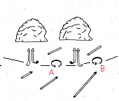
ORGANIZING STAGE
Landspouts/
waterspouts form along convergent, horizontal
wind shear boundaries where
cumuliform clouds are rapidly growing. Small
atmospheric boundary layer vortices called
misocyclones form and propagate along these boundaries (particuarly near boundary intersections).
The "[FONT=Verdana, Arial, Helvetica, sans-serif]
0-3km CAPE (J/kg) and Sfc Vorticity" graphic from the SPC Hourly Mesoanalysis [/FONT]
web page provides perhaps the best weather chart to see this enviroment in real time. This page is generally best because it includes national mesonet surface data (from MesoWest) and RUC model data in its analysis.
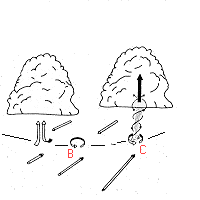
MATURE STAGE
A
landspout/
waterspout may form when a convective updraft becomes co-located with one of these
misocyclones. The
landspout/
waterspout circulation developes from the ground upward as the pre-existing vertical vorticity is streched by the updraft. The horizontal diameter of the
misocyclones decreases which increases the rotational velocity of ciruclation. This is process is analogous to a figure skater which spins faster and faster as she brings her arms in closer to her body. The strongest rotation remains below the cloud base in the
atmospheric boundary layer.
WSR-88D radar loops and 1 km rapid-scan visible satellite loops are necessary for further interrogation and detecting fine scale details in growth and development.
DISSIPATION STAGE
Precipitation induces a downdraft within the
vortex. The
landspout/
waterspout weakens and its vertical exent is reduced as the
cumuliform cloud's updraft weakens.
One of the biggest problems warning forecasters experience is the
landspout/
waterspout has often dissipated when a precipitation echo has reached the surface. However, is one
landspout/
waterspout has developed the mesoscale environment is often primed for more to form.
FORMATION CLUES
Favorable radar indicators for non-supercell (landspout/
waterspout) tornado development include:
- Boundaries exhibiting strong horizontal wind shear
- Collision points of two or more boundaries (example)
- Boundaries possissing wave-like inflections (scalloped appearance) suggesting circulations
- Rapidly developing storms near low-level circulations
- Region along a boundary possessing high radar dBz reflectivity values in clear air return (signature of strong convergence)
- Boundaries with high radar specturm width values (which imply strong wind shear)
RADAR DETECTION PROBLEMS
- Landspouts/
waterspouts may form before any precipitation echo has developed.
- The small horizontal extent of the circulation limits the detectable range.
- The strongest rotation is confined to low levels (the
atmospheric boundary layer).
Thus,
radar horizon problems prevent us from seeing boundaries beyond about 50-60 miles from the radar and misocyclones beyond about 20-30 miles.


